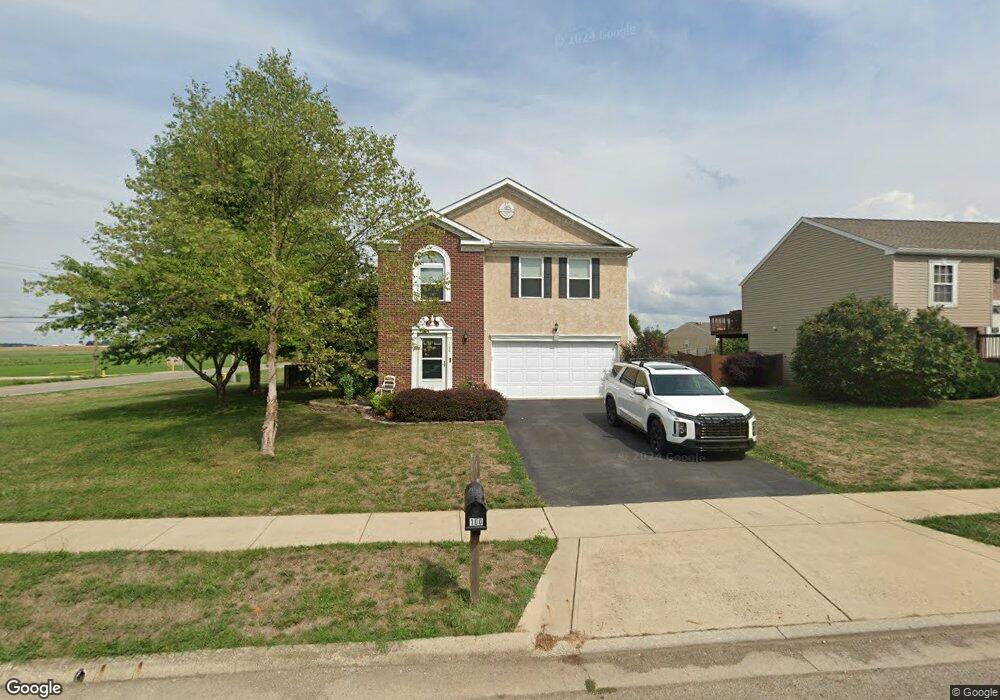
100 Scioto Landing Blvd South Bloomfield, OH 43103
Estimated Value: $316,000 - $358,000
4
Beds
3
Baths
2,096
Sq Ft
$161/Sq Ft
Est. Value
About This Home
This home is located at 100 Scioto Landing Blvd, South Bloomfield, OH 43103 and is currently estimated at $337,939, approximately $161 per square foot. 100 Scioto Landing Blvd is a home located in Pickaway County.
Ownership History
Date
Name
Owned For
Owner Type
Purchase Details
Closed on
Apr 29, 2009
Sold by
Maronda Homes Inc Of Ohio
Bought by
Reed Ryan J and Reed Jamie
Current Estimated Value
Home Financials for this Owner
Home Financials are based on the most recent Mortgage that was taken out on this home.
Original Mortgage
$139,948
Outstanding Balance
$88,422
Interest Rate
4.85%
Mortgage Type
Purchase Money Mortgage
Estimated Equity
$249,517
Purchase Details
Closed on
Jul 29, 2002
Sold by
Landvest Llc
Bought by
Maronda Homes Inc Of Ohio
Create a Home Valuation Report for This Property
The Home Valuation Report is an in-depth analysis detailing your home's value as well as a comparison with similar homes in the area
Home Values in the Area
Average Home Value in this Area
Purchase History
| Date | Buyer | Sale Price | Title Company |
|---|---|---|---|
| Reed Ryan J | $137,200 | Stewart Title | |
| Maronda Homes Inc Of Ohio | $585,000 | -- |
Source: Public Records
Mortgage History
| Date | Status | Borrower | Loan Amount |
|---|---|---|---|
| Open | Reed Ryan J | $139,948 |
Source: Public Records
Tax History Compared to Growth
Tax History
| Year | Tax Paid | Tax Assessment Tax Assessment Total Assessment is a certain percentage of the fair market value that is determined by local assessors to be the total taxable value of land and additions on the property. | Land | Improvement |
|---|---|---|---|---|
| 2024 | -- | $88,380 | $7,130 | $81,250 |
| 2023 | $3,389 | $88,380 | $7,130 | $81,250 |
| 2022 | $2,685 | $64,510 | $5,990 | $58,520 |
| 2021 | $2,542 | $64,510 | $5,990 | $58,520 |
| 2020 | $2,549 | $64,510 | $5,990 | $58,520 |
| 2019 | $2,052 | $54,410 | $5,990 | $48,420 |
| 2018 | $2,243 | $54,410 | $5,990 | $48,420 |
| 2017 | $2,952 | $54,410 | $5,990 | $48,420 |
| 2016 | $1,897 | $44,650 | $5,960 | $38,690 |
| 2015 | $1,898 | $44,650 | $5,960 | $38,690 |
| 2014 | $1,899 | $44,650 | $5,960 | $38,690 |
| 2013 | $2,001 | $45,470 | $5,960 | $39,510 |
Source: Public Records
Map
Nearby Homes
- Beacon Plan at Day Farm - Maple Street Collection
- Greenbriar Plan at Day Farm - Maple Street Collection
- Jensen Plan at Day Farm - Maple Street Collection
- Breckenridge Plan at Day Farm - Maple Street Collection
- Yosemite Plan at Day Farm - Maple Street Collection
- Danville Plan at Day Farm - Maple Street Collection
- Fairfax Plan at Day Farm - Maple Street Collection
- Cumberland Plan at Day Farm - Maple Street Collection
- Wesley Plan at Day Farm - Maple Street Collection
- 5420 Gordon St
- 52 River Bend Dr
- 5332 Karst Cir
- Chestnut Plan at Day Farm
- Cooper Plan at Day Farm
- Bradford Plan at Day Farm
- Ironwood Plan at Day Farm
- Ashton Plan at Day Farm
- Empress Plan at Day Farm
- Norway Plan at Day Farm
- Spruce Plan at Day Farm
- 102 Scioto Landing Blvd
- 104 Scioto Landing Blvd
- 101 Scioto Landing Blvd
- 106 Scioto Landing Blvd
- 103 Scioto Landing Blvd
- 105 Scioto Landing Blvd
- 108 Scioto Landing Blvd
- 346 Karst Cir
- 41 River Ct
- 344 Karst Cir
- 110 Scioto Landing Blvd
- 343 Karst Cir
- 341 Karst Cir
- 342 Karst Cir
- 43 River Ct
- 112 Scioto Landing Blvd
- 340 Karst Cir
- 42 River Ct
- 42 River Ct
- 5022 Farmhouse Rd Unit 36658583