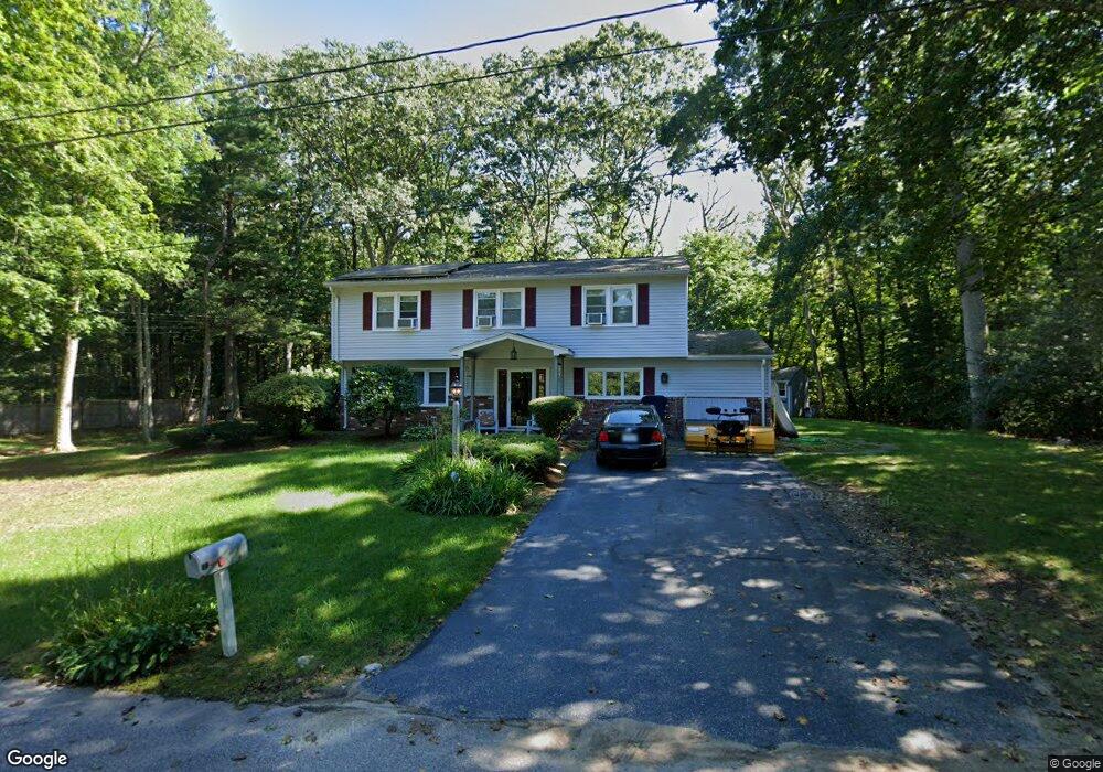
100 Travis Rd Holliston, MA 01746
Estimated Value: $723,171 - $803,000
4
Beds
3
Baths
2,556
Sq Ft
$294/Sq Ft
Est. Value
About This Home
This home is located at 100 Travis Rd, Holliston, MA 01746 and is currently estimated at $752,293, approximately $294 per square foot. 100 Travis Rd is a home located in Middlesex County with nearby schools including Placentino Elementary School, Miller Elementary School, and Robert H. Adams Middle School.
Ownership History
Date
Name
Owned For
Owner Type
Purchase Details
Closed on
Jun 29, 2016
Sold by
Mckenna Joseph W and Mckenna Elizabeth A
Bought by
Mckenna Elizabeth A
Current Estimated Value
Purchase Details
Closed on
May 3, 2016
Sold by
Mckenna Elizabeth A and Mckenna Joseph W
Bought by
Mckenna Elizabeth A and Mckenna Joseph W
Purchase Details
Closed on
Jul 30, 2013
Sold by
Mckenna Josph W and Mckenna Elizabeth A
Bought by
Mckenna Elizabeth A
Purchase Details
Closed on
Dec 6, 2004
Sold by
Ferrioli Bernice V and Mckenna Elizabeth Anne
Bought by
Oak St Prop Mgmt Llc
Create a Home Valuation Report for This Property
The Home Valuation Report is an in-depth analysis detailing your home's value as well as a comparison with similar homes in the area
Home Values in the Area
Average Home Value in this Area
Purchase History
| Date | Buyer | Sale Price | Title Company |
|---|---|---|---|
| Mckenna Elizabeth A | -- | -- | |
| Mckenna Elizabeth A | -- | -- | |
| Mckenna Elizabeth A | -- | -- | |
| Mckenna Elizabeth A | -- | -- | |
| Mckenna Elizabeth A | -- | -- | |
| Mckenna Elizabeth A | -- | -- | |
| Oak St Prop Mgmt Llc | $360,000 | -- | |
| Oak St Prop Mgmt Llc | $360,000 | -- |
Source: Public Records
Mortgage History
| Date | Status | Borrower | Loan Amount |
|---|---|---|---|
| Previous Owner | Oak St Prop Mgmt Llc | $33,500 | |
| Previous Owner | Oak St Prop Mgmt Llc | $126,000 |
Source: Public Records
Tax History Compared to Growth
Tax History
| Year | Tax Paid | Tax Assessment Tax Assessment Total Assessment is a certain percentage of the fair market value that is determined by local assessors to be the total taxable value of land and additions on the property. | Land | Improvement |
|---|---|---|---|---|
| 2025 | $9,398 | $641,500 | $269,000 | $372,500 |
| 2024 | $8,696 | $577,400 | $269,000 | $308,400 |
| 2023 | $8,690 | $564,300 | $269,000 | $295,300 |
| 2022 | $8,509 | $489,600 | $269,000 | $220,600 |
| 2021 | $8,341 | $467,300 | $246,700 | $220,600 |
| 2020 | $8,224 | $436,300 | $243,900 | $192,400 |
| 2019 | $7,617 | $404,500 | $212,100 | $192,400 |
| 2018 | $7,552 | $404,500 | $212,100 | $192,400 |
| 2017 | $7,397 | $399,400 | $204,100 | $195,300 |
| 2016 | $6,984 | $371,700 | $178,200 | $193,500 |
| 2015 | $5,580 | $287,900 | $159,400 | $128,500 |
Source: Public Records
Map
Nearby Homes
- 11 Wingate Rd
- 3 Danforth Dr
- 1 Danforth Dr
- 152 Turner Rd Unit 13
- 152 Turner Rd Unit 43
- 147 Turner Rd Unit 80
- 33 Garett Way Unit 33
- 37 Garett Way Unit 37
- 151 Mohawk Path
- 74 Meeting House Path
- 8 Raymond Way
- 26 Meeting House Path Unit 26
- 277 Meeting House Path
- 1366 Washington St
- 306 Trailside Way
- 63 Trailside Way Unit 63
- 67 Spyglass Hill Dr
- 1037 Washington St
- 373 Eliot St
- 2 Adams Rd Unit 2