Estimated Value: $140,672 - $184,000
3
Beds
2
Baths
1,227
Sq Ft
$133/Sq Ft
Est. Value
About This Home
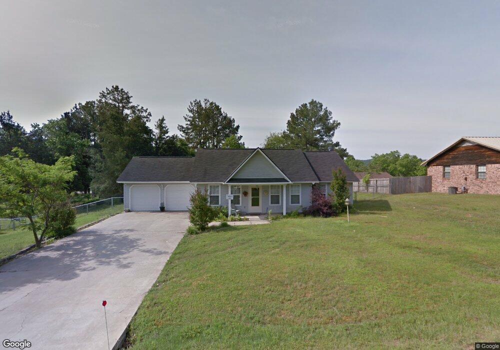
This home is located at 100 W Highview St, Dover, AR 72837 and is currently estimated at $163,668, approximately $133 per square foot. 100 W Highview St is a home located in Pope County with nearby schools including Dover Intermediate School, Dover Elementary School, and Dover Middle School.
Ownership History
Date
Name
Owned For
Owner Type
Purchase Details
Closed on
Sep 23, 2024
Sold by
Hoenig Mary Elizabeth
Bought by
Scienze Georgia Hoenig
Current Estimated Value
Purchase Details
Closed on
Sep 29, 2008
Sold by
Sykes Jason D and Sykes Tanna L
Bought by
Hoenig Robert M
Home Financials for this Owner
Home Financials are based on the most recent Mortgage that was taken out on this home.
Original Mortgage
$80,000
Interest Rate
6.52%
Purchase Details
Closed on
Sep 19, 2008
Sold by
Not Provided
Bought by
Hoenig Robert M
Home Financials for this Owner
Home Financials are based on the most recent Mortgage that was taken out on this home.
Original Mortgage
$80,000
Interest Rate
6.52%
Create a Home Valuation Report for This Property
The Home Valuation Report is an in-depth analysis detailing your home's value as well as a comparison with similar homes in the area
Purchase History
| Date | Buyer | Sale Price | Title Company |
|---|---|---|---|
| Scienze Georgia Hoenig | -- | None Listed On Document | |
| Hoenig Robert M | -- | -- | |
| Hoenig Robert M | $108,000 | -- |
Source: Public Records
Mortgage History
| Date | Status | Borrower | Loan Amount |
|---|---|---|---|
| Previous Owner | Hoenig Robert M | $76,005 | |
| Previous Owner | Hoenig Robert M | $80,000 |
Source: Public Records
Tax History
| Year | Tax Paid | Tax Assessment Tax Assessment Total Assessment is a certain percentage of the fair market value that is determined by local assessors to be the total taxable value of land and additions on the property. | Land | Improvement |
|---|---|---|---|---|
| 2025 | $1,103 | $22,980 | $1,600 | $21,380 |
| 2024 | $1,103 | $22,980 | $1,600 | $21,380 |
| 2023 | $1,066 | $22,980 | $1,600 | $21,380 |
| 2022 | $985 | $22,980 | $1,600 | $21,380 |
| 2021 | $902 | $22,980 | $1,600 | $21,380 |
| 2020 | $820 | $17,080 | $1,600 | $15,480 |
| 2019 | $820 | $17,080 | $1,600 | $15,480 |
| 2018 | $820 | $17,080 | $1,600 | $15,480 |
| 2017 | $820 | $17,080 | $1,600 | $15,480 |
| 2016 | $820 | $17,080 | $1,600 | $15,480 |
| 2015 | $793 | $17,380 | $1,600 | $15,780 |
| 2014 | $779 | $17,380 | $1,600 | $15,780 |
Source: Public Records
Map
Nearby Homes
- 124 Hillcrest St
- 66 W Walker Dr
- 266 Arkansas 164
- 9566 Market St
- 295 E Camp St
- 958 Arkansas 164
- 0 Ln Unit 1331991
- Lot 6 Melvin Ln
- 178 Grandview Dr
- 21 S Elizabeth St
- 188 W Water St
- 43 Autumn Ct
- 636 Sr 164 E
- 0 Market St Unit 1332944
- 13956 Highway 7
- 400 Owen Wait Rd
- 30 Ashdown Ln
- 1375 Pine Hill Rd
- 2619 Arkansas 164
- 3515 Linker Mountain Rd
- 86 W Highview St
- 120 W Highview St
- 268 Meadow Ln
- 234 Meadow Ln
- 131 W Highview St
- 20 W Highview St
- 247 Meadow Ln
- 126 E Walker Dr
- 155 Hillcrest St
- 18 W Highview St
- 133 Hillcrest St
- 166 E Walker Dr
- 11 W Walker Dr
- 187 Hillcrest St
- 111 Hillcrest St
- 54 E Walker Dr
- 88 E Walker Dr
- 21 W Highview St
- 174 E Walker Dr
Your Personal Tour Guide
Ask me questions while you tour the home.