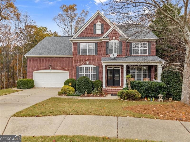
1000 Island Bluff Ln Unit 1 Buford, GA 30518
Estimated payment $3,401/month
Highlights
- Clubhouse
- Deck
- Traditional Architecture
- White Oak Elementary School Rated A
- Private Lot
- Wood Flooring
About This Home
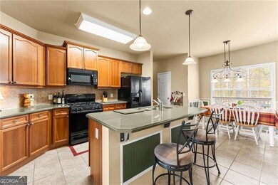
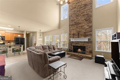
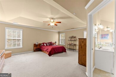
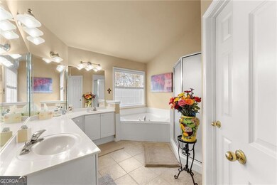
Discover the perfect blend of lake-life convenience, neighborhood charm, and timeless architectural details in this beautifully situated brick-front home on a quiet cul-de-sac in the River Falls community near Lake Lanier. A welcoming covered front porch sets the tone, inviting you into a warm and thoughtfully designed interior. Crafted with both comfort and functionality in mind, the main level features elegant crown molding throughout and an open-concept layout that flows effortlessly from the bright kitchen into the grand two-story family room. Here, a stunning stack-stone fireplace climbs all the way to the ceiling, creating a striking focal point for gatherings. A spacious dining room with tray ceilings offers the perfect setting for hosting family dinners or holidays. The large master suite continues the theme of comfort, showcasing tray ceilings and a generous master bathroom complete with double vanity sinks, a separate shower, and a relaxing soaking tub. Outdoor enthusiasts will love the extra-deep double garage-large enough to securely store a 21-foot trailered boat in a temperature-controlled, weatherproof environment. Load and unload your gear with ease, then enjoy a quick 10-minute drive to the public boat ramp. After a day on the water, simply back into the garage and leave everything in place, ready for your next adventure. There's still plenty of room for your vehicle and additional storage. Even more recreation awaits just a 15-minute bike ride away at Lake Lanier Beach Park and Fishing Pier, a beautiful Army Corps of Engineers park featuring deep, clear water near Buford Dam, marked swimming areas, restrooms, and picnic spaces. The finished basement expands your living and entertaining possibilities with a stylish bar area, additional living space, and abundant storage options. Step outside to a private backyard retreat featuring an upper deck and a covered lower patio-perfect for peaceful mornings, grilling, or relaxing with friends while enjoying wooded privacy. Located in a quiet, established 130-home neighborhood with a single entrance, River Falls offers exceptional privacy, security, and enduring community charm. Neighborhood highlights include a five-lane swimming pool (resurfaced in Fall 2025), two lighted tennis courts with pickleball striping, a welcoming cabana with fireplace and bathrooms, professional landscaping of all common areas, and a well-managed POA that protects property values and upholds high community standards. Its ideal location between GA-400 and I-985 ensures easy commuting and quick access to shopping, dining, and schools. Enjoy the best of lake living, outdoor recreation, generous indoor and outdoor spaces, and top-tier neighborhood amenities-all right at your doorstep.
Open House Schedule
-
Sunday, December 14, 202512:00 to 2:00 pm12/14/2025 12:00:00 PM +00:0012/14/2025 2:00:00 PM +00:00Add to Calendar
Home Details
Home Type
- Single Family
Est. Annual Taxes
- $5,922
Year Built
- Built in 2002
Lot Details
- 0.34 Acre Lot
- Cul-De-Sac
- Private Lot
- Sloped Lot
HOA Fees
- $67 Monthly HOA Fees
Home Design
- Traditional Architecture
- Composition Roof
- Brick Front
Interior Spaces
- 3,356 Sq Ft Home
- 2-Story Property
- Rear Stairs
- Tray Ceiling
- Ceiling Fan
- Gas Log Fireplace
- Double Pane Windows
- Entrance Foyer
- Family Room
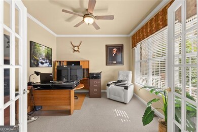
- Home Office
Kitchen
- Walk-In Pantry
- Oven or Range
- Microwave
- Dishwasher
- Disposal
Flooring
- Wood
- Carpet
- Tile
Bedrooms and Bathrooms
- 4 Bedrooms
- Walk-In Closet
- Bathtub Includes Tile Surround
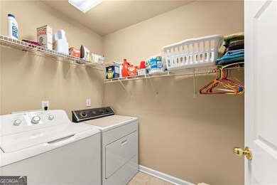
Laundry
- Laundry Room
- Laundry on upper level
- Dryer
- Washer
Basement
- Partial Basement
- Exterior Basement Entry
- Finished Basement Bathroom
- Natural lighting in basement
Home Security
- Carbon Monoxide Detectors
- Fire and Smoke Detector
Parking
- 2 Car Garage
- Garage Door Opener
Schools
- White Oak Elementary School
- Lanier Middle School
- Lanier High School
Utilities
- Central Air
- Heat Pump System
- Underground Utilities
- Gas Water Heater
- High Speed Internet
- Phone Available
- Satellite Dish
- Cable TV Available
Additional Features
- Energy-Efficient Thermostat
- Deck
- Property is near schools
Listing and Financial Details
- Tax Block A
Community Details
Overview
- $800 Initiation Fee
- Association fees include ground maintenance, pest control, swimming, tennis
- River Falls Subdivision
Amenities
- Clubhouse
Recreation
- Tennis Courts
- Community Playground
- Community Pool
Map
Home Values in the Area
Average Home Value in this Area
Tax History
| Year | Tax Paid | Tax Assessment Tax Assessment Total Assessment is a certain percentage of the fair market value that is determined by local assessors to be the total taxable value of land and additions on the property. | Land | Improvement |
|---|---|---|---|---|
| 2025 | -- | $242,480 | $50,000 | $192,480 |
| 2024 | $5,922 | $204,760 | $39,600 | $165,160 |
| 2023 | $5,922 | $204,760 | $39,600 | $165,160 |
| 2022 | $5,383 | $180,080 | $24,800 | $155,280 |
| 2021 | $4,613 | $139,160 | $24,800 | $114,360 |
| 2020 | $4,645 | $139,160 | $24,800 | $114,360 |
| 2019 | $4,233 | $126,440 | $24,800 | $101,640 |
| 2018 | $4,131 | $121,400 | $22,000 | $99,400 |
| 2016 | $3,683 | $101,840 | $19,360 | $82,480 |
| 2015 | $3,724 | $101,840 | $19,360 | $82,480 |
| 2014 | -- | $101,840 | $19,360 | $82,480 |
Property History
| Date | Event | Price | List to Sale | Price per Sq Ft |
|---|---|---|---|---|
| 12/01/2025 12/01/25 | Price Changed | $540,000 | -1.8% | $161 / Sq Ft |
| 11/12/2025 11/12/25 | For Sale | $550,000 | -- | $164 / Sq Ft |
Purchase History
| Date | Type | Sale Price | Title Company |
|---|---|---|---|
| Deed | $276,700 | -- |
Mortgage History
| Date | Status | Loan Amount | Loan Type |
|---|---|---|---|
| Open | $215,000 | New Conventional | |
| Closed | $30,000 | Stand Alone Refi Refinance Of Original Loan |
Source: Georgia MLS
MLS Number: 10642622
APN: 7-364-218
Disclaimer: Certain information contained herein is derived from information provided by parties other than Homes.com. All information provided is deemed reliable, but is not guaranteed to be accurate and should be independently verified.
![]() The data relating to real estate for sale on this web site comes in part from the Broker Reciprocity Program of Georgia MLS. Real estate listings held by brokerage firms other than Redfin are marked with the Broker Reciprocity logo and detailed information about them includes the name of the listing brokers. Information deemed reliable but not guaranteed. Copyright 2025 Georgia MLS. All rights reserved.
The data relating to real estate for sale on this web site comes in part from the Broker Reciprocity Program of Georgia MLS. Real estate listings held by brokerage firms other than Redfin are marked with the Broker Reciprocity logo and detailed information about them includes the name of the listing brokers. Information deemed reliable but not guaranteed. Copyright 2025 Georgia MLS. All rights reserved.
- 6597 River Island Dr
- 6945 Melody Ridge Rd
- 1038 Island View Ct Unit 2
- 6944 Melody Ridge Rd
- 6935 Melody Ridge Rd
- The Danbury C Plan at Melody Lakeside Estates
- The Hampton B Plan at Melody Lakeside Estates
- The Hickory B Plan at Melody Lakeside Estates
- 6670 Island Pointe Dr
- 852 van Briggle Path
- 6479 Mobilis Ct
- 6385 Grand Magnolia Dr
- 1114 Blue Water Ct
- 6330 Weller Trail
- 6427 Blue Water Dr
- 6437 Blue Water Dr
- 932 Homepark Cir
- 942 Homepark Cir
- 972 Homepark Cir
- 6858 Pierless Ave
- 1201 Bavarian Wood Close
- 1093 Sparkling Cove Dr
- 1243 Sparkling Cove Dr
- 6066 Barker Landing NE Unit ID1254400P
- 6036 Barker Landing NE Unit ID1254415P
- 6046 Barker Landing NE Unit ID1254396P
- 5986 Trail Hikes Dr Unit ID1254386P
- 775 Riverside Walk Crossing NE
- 6009 Mock Ives Ct NE Unit ID1341828P
- 921 Upland Ives Dr
- 5960 River Ridge Ln
- 738 Austin Creek Dr
- 816 Dodd Trail
- 816 Dodd Trail
- 5868 Valine Way
- 800 Johnson Mill Terrace
- 6180 Misty Hill Ln
- 888 Saddlebred Way
- 5108 City Walk Dr
- 5495 Sugar Crossing Dr
