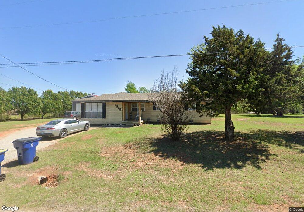
1000 Kent Dr Choctaw, OK 73020
Estimated Value: $158,000 - $271,000
2
Beds
1
Bath
1,416
Sq Ft
$150/Sq Ft
Est. Value
About This Home
This home is located at 1000 Kent Dr, Choctaw, OK 73020 and is currently estimated at $212,433, approximately $150 per square foot. 1000 Kent Dr is a home located in Oklahoma County with nearby schools including Choctaw Elementary School, Choctaw Middle School, and Choctaw High School.
Ownership History
Date
Name
Owned For
Owner Type
Purchase Details
Closed on
Jun 26, 2009
Sold by
Daggs Deloris Jean Young and Daggs Felix L
Bought by
Young Brian K and Young Paula M
Current Estimated Value
Purchase Details
Closed on
Apr 19, 1999
Sold by
Goforth Dale A and Goforth Barbara A
Bought by
Hobbs Christopher S and Hobbs Leslie Ann
Home Financials for this Owner
Home Financials are based on the most recent Mortgage that was taken out on this home.
Original Mortgage
$152,000
Interest Rate
7.06%
Mortgage Type
Construction
Create a Home Valuation Report for This Property
The Home Valuation Report is an in-depth analysis detailing your home's value as well as a comparison with similar homes in the area
Home Values in the Area
Average Home Value in this Area
Purchase History
| Date | Buyer | Sale Price | Title Company |
|---|---|---|---|
| Young Brian K | $54,000 | First American Title | |
| Hobbs Christopher S | $40,000 | First Amer Title & Trust Co |
Source: Public Records
Mortgage History
| Date | Status | Borrower | Loan Amount |
|---|---|---|---|
| Previous Owner | Hobbs Christopher S | $152,000 |
Source: Public Records
Tax History Compared to Growth
Tax History
| Year | Tax Paid | Tax Assessment Tax Assessment Total Assessment is a certain percentage of the fair market value that is determined by local assessors to be the total taxable value of land and additions on the property. | Land | Improvement |
|---|---|---|---|---|
| 2024 | $953 | $9,341 | $1,826 | $7,515 |
| 2023 | $953 | $9,069 | $742 | $8,327 |
| 2022 | $906 | $8,804 | $757 | $8,047 |
| 2021 | $877 | $8,548 | $796 | $7,752 |
| 2020 | $747 | $7,392 | $701 | $6,691 |
| 2019 | $722 | $7,176 | $680 | $6,496 |
| 2018 | $700 | $6,968 | $0 | $0 |
| 2017 | $674 | $6,764 | $1,627 | $5,137 |
| 2016 | $678 | $6,764 | $1,627 | $5,137 |
| 2015 | $764 | $7,489 | $1,627 | $5,862 |
| 2014 | $855 | $8,184 | $1,627 | $6,557 |
Source: Public Records
Map
Nearby Homes
- 1312 Lighthorsemen Way
- 1306 Lighthorsemen Way
- 1315 Pushmataha Blvd
- 1308 Pushmataha Blvd
- 1306 Pushmataha Blvd
- 1300 Lighthorsemen Way
- 1316 Lighthorsemen Way
- 1311 Pushmataha Blvd
- 1309 Lighthorsemen Way
- 1313 Lighthorsemen Way
- 1304 Lighthorsemen Way
- 900 N Choctaw Rd
- 0 NE Rd Unit 1145972
- 0 Morningside Dr
- 769 Silver Chase Dr
- 818 Silver Tree Dr
- 680 Silver Tree Dr
- 1721 Cherokee Trail
- 1917 Overland Trail
- 1006 Oak Park Dr
- 15510 NE 10th St
- 1024 Kent Dr
- 15505 NE 10th St
- 15501 NE 10th St
- 1020 Kent Dr
- 996 Kent Dr
- 15652 NE 10th St
- 900 Kent Dr
- 15732 NE 10th St
- 1304 Way
- 1313 Lighthorseman Way
- 1300 Lighthorseman Way
- 15736 NE 10th St
- 891 Kent Dr
- 15738 NE 10th St
- 15659 Kent Dr
- 700 Kent Dr
- 15733 NE 10th St
- 15675 Kent Dr
- 15201 NE 10th St