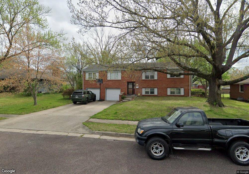
1000 Westport Dr Columbia, MO 65203
Estimated Value: $312,000 - $327,000
4
Beds
3
Baths
2,493
Sq Ft
$128/Sq Ft
Est. Value
About This Home
This home is located at 1000 Westport Dr, Columbia, MO 65203 and is currently estimated at $319,737, approximately $128 per square foot. 1000 Westport Dr is a home located in Boone County with nearby schools including Fairview Elementary School, West Middle School, and David H. Hickman High School.
Ownership History
Date
Name
Owned For
Owner Type
Purchase Details
Closed on
Mar 4, 2024
Sold by
Deering Julie Beth
Bought by
Martin Jeffrey Alan
Current Estimated Value
Purchase Details
Closed on
Dec 15, 2005
Sold by
Linch Wanda K and Linch Kenneth V
Bought by
Martin Jeffry A and Martin Tammy J
Home Financials for this Owner
Home Financials are based on the most recent Mortgage that was taken out on this home.
Original Mortgage
$152,250
Interest Rate
6.29%
Mortgage Type
New Conventional
Create a Home Valuation Report for This Property
The Home Valuation Report is an in-depth analysis detailing your home's value as well as a comparison with similar homes in the area
Home Values in the Area
Average Home Value in this Area
Purchase History
| Date | Buyer | Sale Price | Title Company |
|---|---|---|---|
| Martin Jeffrey Alan | -- | None Listed On Document | |
| Martin Jeffry A | -- | None Available |
Source: Public Records
Mortgage History
| Date | Status | Borrower | Loan Amount |
|---|---|---|---|
| Previous Owner | Martin Jeffry A | $152,250 |
Source: Public Records
Tax History Compared to Growth
Tax History
| Year | Tax Paid | Tax Assessment Tax Assessment Total Assessment is a certain percentage of the fair market value that is determined by local assessors to be the total taxable value of land and additions on the property. | Land | Improvement |
|---|---|---|---|---|
| 2025 | $2,098 | $35,606 | $4,655 | $30,951 |
| 2024 | $2,098 | $31,103 | $4,655 | $26,448 |
| 2023 | $2,081 | $31,103 | $4,655 | $26,448 |
| 2022 | $1,925 | $28,804 | $4,655 | $24,149 |
| 2021 | $1,929 | $28,804 | $4,655 | $24,149 |
| 2020 | $1,901 | $26,676 | $4,655 | $22,021 |
| 2019 | $1,901 | $26,676 | $4,655 | $22,021 |
| 2018 | $1,773 | $0 | $0 | $0 |
| 2017 | $1,751 | $24,700 | $4,655 | $20,045 |
| 2016 | $1,797 | $24,700 | $4,655 | $20,045 |
| 2015 | $1,658 | $24,700 | $4,655 | $20,045 |
| 2014 | $1,667 | $24,700 | $4,655 | $20,045 |
Source: Public Records
Map
Nearby Homes
- 811 Cambridge Dr
- 3005 W Rollins Rd
- 908 S Fairview Rd
- 804 S Fairview Rd Unit B7
- 503 Himalayas Dr
- 502 Carpathian Dr
- 1300 Longwell Dr
- 1305 Jake Ln
- 401 Hulen Dr
- 1416 Subella Dr
- 3817 Bray Ct
- 3211 Kohler Cir
- 3808 Faurot Dr
- 504 Loch Ln
- 2304 Braemore Rd
- 2505 Highland Dr
- 2802 W Broadway
- 2708 W Broadway
- 2306 Woodridge Rd
- 108 Defoe Ct
- 1004 Westport Dr
- 908 Westport Dr
- 1001 Plymouth Dr
- 1005 Plymouth Dr
- 911 Plymouth Dr
- 1008 Westport Dr
- 906 Westport Dr
- 1001 Westport Dr
- 1005 Westport Dr
- 1009 Plymouth Dr
- 909 Westport Dr
- 1009 Westport Dr
- 1012 Westport Dr
- 905 Westport Dr
- 3108 Yorktown Dr
- 3104 Yorktown Dr
- 1013 Plymouth Dr
- 1013 Westport Dr
- 3100 Yorktown Dr
- 1014 Westport Dr