Estimated Value: $526,000 - $559,000
4
Beds
3
Baths
2,764
Sq Ft
$197/Sq Ft
Est. Value
About This Home
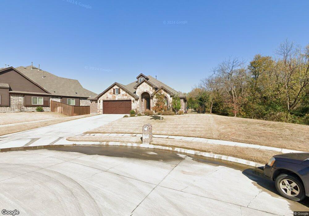
This home is located at 1001 Cambridge Ct, Wylie, TX 75098 and is currently estimated at $543,244, approximately $196 per square foot. 1001 Cambridge Ct is a home located in Collin County with nearby schools including P M Akin Elementary School, AB Harrison Intermediate School, and Grady Burnett J High School.
Ownership History
Date
Name
Owned For
Owner Type
Purchase Details
Closed on
Apr 24, 2015
Sold by
Bloomfield Homes Lp
Bought by
Nay Robert D and Nay Melissa E
Current Estimated Value
Home Financials for this Owner
Home Financials are based on the most recent Mortgage that was taken out on this home.
Original Mortgage
$335,071
Outstanding Balance
$259,343
Interest Rate
3.89%
Mortgage Type
VA
Estimated Equity
$283,901
Create a Home Valuation Report for This Property
The Home Valuation Report is an in-depth analysis detailing your home's value as well as a comparison with similar homes in the area
Home Values in the Area
Average Home Value in this Area
Purchase History
| Date | Buyer | Sale Price | Title Company |
|---|---|---|---|
| Nay Robert D | -- | Fatco |
Source: Public Records
Mortgage History
| Date | Status | Borrower | Loan Amount |
|---|---|---|---|
| Open | Nay Robert D | $335,071 |
Source: Public Records
Tax History Compared to Growth
Tax History
| Year | Tax Paid | Tax Assessment Tax Assessment Total Assessment is a certain percentage of the fair market value that is determined by local assessors to be the total taxable value of land and additions on the property. | Land | Improvement |
|---|---|---|---|---|
| 2025 | $8,595 | $550,350 | $136,500 | $413,850 |
| 2024 | $8,595 | $503,118 | $136,500 | $418,664 |
| 2023 | $8,595 | $457,380 | $115,500 | $428,179 |
| 2022 | $9,122 | $415,800 | $115,500 | $372,995 |
| 2021 | $8,894 | $378,000 | $84,000 | $294,000 |
| 2020 | $8,981 | $361,690 | $84,000 | $277,690 |
| 2019 | $9,926 | $377,710 | $84,000 | $293,710 |
| 2018 | $9,982 | $370,659 | $84,000 | $286,659 |
| 2017 | $9,771 | $362,812 | $84,000 | $278,812 |
| 2016 | $9,629 | $346,548 | $84,000 | $262,548 |
| 2015 | -- | $50,400 | $50,400 | $0 |
Source: Public Records
Map
Nearby Homes
- 213 N West A Allen Blvd
- 1056 Fairview Dr
- 304 Hawthorn Dr
- 310 Hawthorn Dr
- 1209 Surrey Cir
- 107 Windy Knoll Ln
- 409 Cedar Ridge Dr
- 306 Foxwood Ct
- 216 Cedar Ridge St
- 114 Liberty Dr
- 825 Foxwood Ln
- 312 Maltese Cir
- 820 Foxwood Ln
- 104 Rushcreek Dr
- 1115 Nighthawk Dr
- 207 Spence Dr
- 825 Forest Edge Ln
- 811 Forest Edge Ln
- 1201 E Stone Rd
- 1308 London Dr
- 1003 Cambridge Ct
- 1005 Cambridge Ct
- 1002 Cambridge Ct
- 1007 Cambridge Ct
- 1000 Cambridge Ct
- 1004 Cambridge Ct
- 1006 Cambridge Ct
- 106 Queensgate Dr
- 106 Queensgate Dr
- 104 Queensgate Dr
- 1008 Cambridge Ct
- 201 Lyndhurst Dr
- 201 Lyndhurst Dr
- 1005 Stanbridge Dr
- 1007 Stanbridge Dr
- 102 Queensgate Dr
- 1009 Stanbridge Dr
- 1010 Cambridge Ct
- 1010 Cambridge Ct
- 111 Queensgate Dr