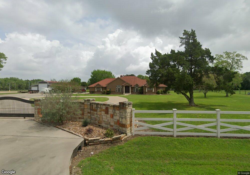
1001 Nichols Ave Bay City, TX 77414
Estimated Value: $480,000 - $831,000
--
Bed
--
Bath
4,083
Sq Ft
$156/Sq Ft
Est. Value
About This Home
This home is located at 1001 Nichols Ave, Bay City, TX 77414 and is currently estimated at $636,925, approximately $155 per square foot. 1001 Nichols Ave is a home located in Matagorda County with nearby schools including John H. Cherry Elementary School, Bay City Junior High School, and Bay City High School.
Ownership History
Date
Name
Owned For
Owner Type
Purchase Details
Closed on
Jul 30, 2013
Sold by
Allison James Grant and Maloney James Vincent
Bought by
Pescado Rojo Properties Llc
Current Estimated Value
Home Financials for this Owner
Home Financials are based on the most recent Mortgage that was taken out on this home.
Original Mortgage
$198,000
Outstanding Balance
$144,500
Interest Rate
3.93%
Estimated Equity
$492,425
Create a Home Valuation Report for This Property
The Home Valuation Report is an in-depth analysis detailing your home's value as well as a comparison with similar homes in the area
Home Values in the Area
Average Home Value in this Area
Purchase History
| Date | Buyer | Sale Price | Title Company |
|---|---|---|---|
| Pescado Rojo Properties Llc | -- | None Available |
Source: Public Records
Mortgage History
| Date | Status | Borrower | Loan Amount |
|---|---|---|---|
| Open | Pescado Rojo Properties Llc | $198,000 |
Source: Public Records
Tax History Compared to Growth
Tax History
| Year | Tax Paid | Tax Assessment Tax Assessment Total Assessment is a certain percentage of the fair market value that is determined by local assessors to be the total taxable value of land and additions on the property. | Land | Improvement |
|---|---|---|---|---|
| 2024 | $116 | $751,530 | $86,790 | $664,740 |
| 2023 | $10,534 | $673,900 | $86,790 | $587,110 |
| 2022 | $12,310 | $604,820 | $40,410 | $564,410 |
| 2021 | $10,927 | $478,620 | $40,410 | $438,210 |
| 2020 | $11,898 | $495,500 | $40,410 | $455,090 |
| 2019 | $15,388 | $641,320 | $40,410 | $600,910 |
| 2018 | $13,674 | $596,860 | $40,410 | $556,450 |
| 2017 | $13,171 | $601,450 | $40,410 | $561,040 |
| 2016 | $12,716 | $580,670 | $40,410 | $540,260 |
| 2015 | -- | $564,140 | $40,410 | $523,730 |
| 2014 | -- | $581,160 | $40,410 | $540,750 |
Source: Public Records
Map
Nearby Homes
- 3102 La Vista Ave
- 1500 Andrea Dr
- 5013 Freedom Ln
- 5000 Freedom Ln
- 5020 Freedom Ln
- 2801 Del Monte Ave
- 3108 La Vista Ave
- 5044 Freedom Ln
- 5028 Freedom Ln
- 5036 Freedom Ln
- 1005 Valiant Dr
- Pinehollow Plan at Valor Park
- Whitetail Plan at Valor Park
- 5001 Freedom Ln
- Idlewood Plan at Valor Park
- Kitson Plan at Valor Park
- 1003 Valiant Dr
- 1007 Valiant Dr
- 3233 12th St
- BRISTOL Plan at Valor Park
- 1639 Canal
- 1101-1 Nichols
- 1101 Nichols Ave Unit 1103
- 1105 Nichols Ave
- 1107 Nichols Ave
- 1109 Nichols Ave Unit 1111
- 920 Nichols Ave
- 1113 Nichols Ave
- 880 Nichols Ave
- 1117 Nichols Ave
- 1203 Nichols Ave
- 3101 Skelly Rd
- 1207 Nichols Ave
- 1211 Nichols Ave
- 3401 County Road 106
- 820 Nichols Ave
- 1215 Nichols Ave
- 815 Nichols Ave
- 818 Nichols Ave
- 3402 Cr 106 (Skelly Road)