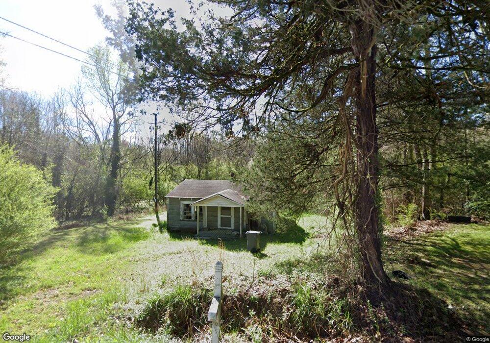
1001 Old Union Point Rd Greensboro, GA 30642
Estimated Value: $63,000 - $153,000
1
Bed
2
Baths
546
Sq Ft
$182/Sq Ft
Est. Value
About This Home
This home is located at 1001 Old Union Point Rd, Greensboro, GA 30642 and is currently estimated at $99,431, approximately $182 per square foot. 1001 Old Union Point Rd is a home located in Greene County with nearby schools including Greene County High School.
Ownership History
Date
Name
Owned For
Owner Type
Purchase Details
Closed on
May 31, 2013
Sold by
Brooks Charlotte
Bought by
Mapp David
Current Estimated Value
Purchase Details
Closed on
Jul 5, 2010
Sold by
Mapp William H
Bought by
Brooks Charlotte A
Purchase Details
Closed on
Feb 12, 2009
Sold by
Mapp William H and Mapp Josephine
Bought by
Mapp William H
Purchase Details
Closed on
Jan 1, 1982
Sold by
Williams Ulysses
Bought by
Mapp Wm Henry and Mapp Josephine
Purchase Details
Closed on
Jan 1, 1960
Bought by
Williams Ulysses
Create a Home Valuation Report for This Property
The Home Valuation Report is an in-depth analysis detailing your home's value as well as a comparison with similar homes in the area
Home Values in the Area
Average Home Value in this Area
Purchase History
| Date | Buyer | Sale Price | Title Company |
|---|---|---|---|
| Mapp David | -- | -- | |
| Brooks Charlotte A | $10,556 | -- | |
| Mapp William H | -- | -- | |
| Mapp Wm Henry | -- | -- | |
| Williams Ulysses | -- | -- |
Source: Public Records
Tax History Compared to Growth
Tax History
| Year | Tax Paid | Tax Assessment Tax Assessment Total Assessment is a certain percentage of the fair market value that is determined by local assessors to be the total taxable value of land and additions on the property. | Land | Improvement |
|---|---|---|---|---|
| 2024 | $479 | $11,160 | $9,440 | $1,720 |
| 2023 | $407 | $11,000 | $9,440 | $1,560 |
| 2022 | $300 | $7,080 | $5,720 | $1,360 |
| 2021 | $266 | $5,200 | $3,960 | $1,240 |
| 2020 | $201 | $1,680 | $760 | $920 |
| 2019 | $201 | $1,680 | $760 | $920 |
| 2018 | $178 | $1,680 | $760 | $920 |
| 2017 | $176 | $1,702 | $765 | $937 |
| 2016 | $176 | $1,702 | $765 | $937 |
| 2015 | $149 | $1,702 | $765 | $937 |
| 2014 | $150 | $1,687 | $765 | $922 |
Source: Public Records
Map
Nearby Homes
- LOT 1 Penfield
- 1131 Planing Mill Rd
- 1141 Planing Mill Rd
- 0 Railroad St Unit 218854
- 0 Railroad St Unit 10578007
- 0 Railroad St Unit 531919
- 1531 E Broad St
- 1020 Horton Dr
- 301 N East St
- 1060 Twin Pines Cir
- 15 South St Unit Siloam Road
- 504 Martin Luther King Junior Dr
- 0 Canaan St
- 314 W South St
- 0 Maple Cir
- 109 Reynolds Dr
- 0 Union Point Hwy Unit 69532
- 0 Union Point Hwy Unit 7607786
- 0 Union Point Hwy Unit 10555176
- 105 Wilson St
- 1281 Old Union Point Rd
- 1721 N East St
- 1031 Old Union Point Rd
- 1051 Old Union Point Rd
- 1661 N East St
- 1670 N East St
- 1240 Pool Rd
- 1781 Penfield Rd
- 0 Pool Rd
- 1121 Pool Rd
- 1111 Pool Rd
- 1021 Webb Lake Dr
- 1051 Webb Lake Dr
- 1071 Webb Lake Dr
- 1091 Webb Lake Dr
- 1830 Penfield Rd
- 1101 Pool Rd
- 1111 Webb Lake Dr
- 1131 Webb Lake Dr
- 1030 Webb Lake Dr