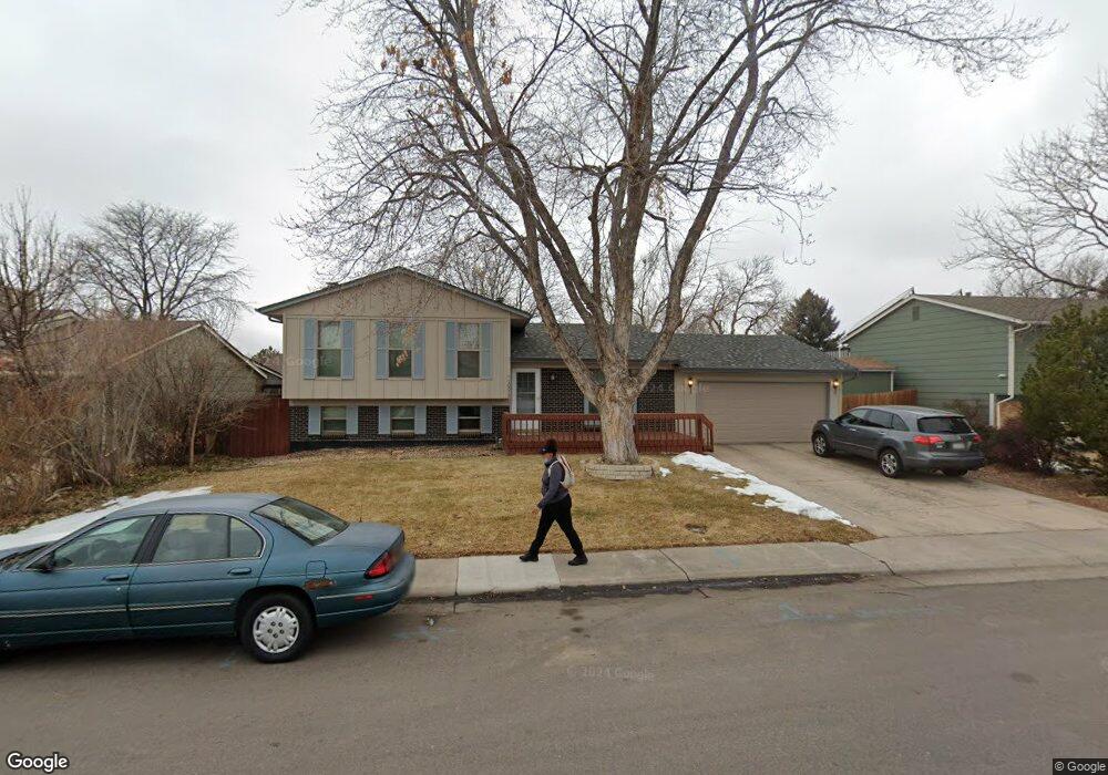
10015 Clay St Denver, CO 80260
Estimated Value: $504,880 - $524,000
4
Beds
3
Baths
1,700
Sq Ft
$304/Sq Ft
Est. Value
About This Home
This home is located at 10015 Clay St, Denver, CO 80260 and is currently estimated at $516,220, approximately $303 per square foot. 10015 Clay St is a home located in Adams County with nearby schools including Hillcrest Elementary School, Silver Hills Middle School, and Northglenn High School.
Ownership History
Date
Name
Owned For
Owner Type
Purchase Details
Closed on
Oct 7, 2013
Sold by
Clary Bonnie G and Kuriger Janie L
Bought by
Clary John K and Clary Bonnie G
Current Estimated Value
Home Financials for this Owner
Home Financials are based on the most recent Mortgage that was taken out on this home.
Original Mortgage
$99,112
Outstanding Balance
$76,586
Interest Rate
5.25%
Mortgage Type
New Conventional
Estimated Equity
$439,634
Purchase Details
Closed on
Jun 3, 2013
Sold by
Foreit Alois J
Bought by
Clary Bonnie G and Kuriger Janie L
Create a Home Valuation Report for This Property
The Home Valuation Report is an in-depth analysis detailing your home's value as well as a comparison with similar homes in the area
Home Values in the Area
Average Home Value in this Area
Purchase History
| Date | Buyer | Sale Price | Title Company |
|---|---|---|---|
| Clary John K | -- | None Available | |
| Clary Bonnie G | -- | None Available |
Source: Public Records
Mortgage History
| Date | Status | Borrower | Loan Amount |
|---|---|---|---|
| Open | Clary John K | $99,112 |
Source: Public Records
Tax History Compared to Growth
Tax History
| Year | Tax Paid | Tax Assessment Tax Assessment Total Assessment is a certain percentage of the fair market value that is determined by local assessors to be the total taxable value of land and additions on the property. | Land | Improvement |
|---|---|---|---|---|
| 2024 | $3,065 | $29,130 | $5,880 | $23,250 |
| 2023 | $3,032 | $34,630 | $5,610 | $29,020 |
| 2022 | $2,599 | $24,580 | $5,770 | $18,810 |
| 2021 | $2,686 | $24,580 | $5,770 | $18,810 |
| 2020 | $2,368 | $22,100 | $5,930 | $16,170 |
| 2019 | $2,373 | $22,100 | $5,930 | $16,170 |
| 2018 | $2,165 | $19,510 | $6,340 | $13,170 |
| 2017 | $1,954 | $19,510 | $6,340 | $13,170 |
| 2016 | $1,616 | $15,640 | $2,950 | $12,690 |
| 2015 | $1,613 | $15,640 | $2,950 | $12,690 |
| 2014 | -- | $13,800 | $2,630 | $11,170 |
Source: Public Records
Map
Nearby Homes
- 10014 Clay St
- 10038 Alcott St
- 9850 N Federal Blvd Unit 59
- 10072 Wyandott Cir S
- 10211 Ura Ln Unit 4-107
- 10211 Ura Ln Unit 5-206
- 10211 Ura Ln Unit 6-307
- 10211 Ura Ln Unit 7-108
- 10211 Ura Ln Unit 104
- 10211 Ura Ln Unit 101
- 10211 Ura Ln Unit 7-204
- 10211 Ura Ln Unit 8-207
- 9934 Grove St Unit D
- 9874 Grove St Unit B
- 10058 Grove Ct Unit E
- 2925 Hawk St Unit 88
- 2123 W 101st Cir
- 2940 Hawk St Unit 78
- 9877 Grove St Unit C
- 2012 W 101st Ave
- 10017 Clay St
- 10013 Clay St
- 2706 W 100th Dr
- 2708 W 100th Dr
- 2704 W 100th Dr
- 2612 W 100th Place
- 10019 Clay St
- 2613 W 100th Place
- 2710 W 100th Dr
- 2702 W 100th Dr
- 2610 W 100th Place
- 2701 W 100th Ave
- 10021 Clay St
- 10012 Clay St
- 2611 W 100th Place
- 10024 Eliot Cir
- 10024 Eliott Cir
- 2700 W 100th Dr
- 2612 W 101st Place
- 2712 W 100th Dr