Estimated Value: $85,000 - $248,000
3
Beds
2
Baths
1,950
Sq Ft
$97/Sq Ft
Est. Value
About This Home
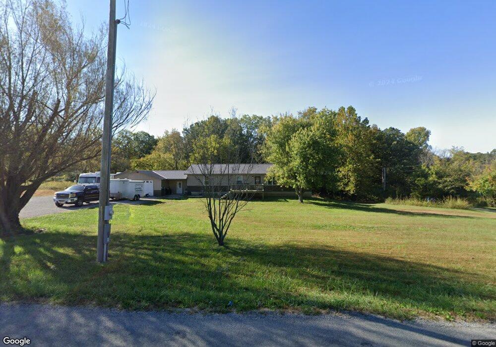
This home is located at 1002 Sharp Rock Rd, Ava, IL 62907 and is currently estimated at $189,321, approximately $97 per square foot. 1002 Sharp Rock Rd is a home located in Jackson County with nearby schools including Trico Elementary School.
Ownership History
Date
Name
Owned For
Owner Type
Purchase Details
Closed on
Jul 28, 2025
Sold by
Thompson Brian and Thompson Carissa
Bought by
Obryan Ivan S
Current Estimated Value
Home Financials for this Owner
Home Financials are based on the most recent Mortgage that was taken out on this home.
Original Mortgage
$228,000
Outstanding Balance
$227,806
Interest Rate
6.81%
Mortgage Type
New Conventional
Estimated Equity
-$38,485
Purchase Details
Closed on
Jun 15, 2009
Sold by
Newton Rena M
Bought by
Thompson Brian and Gordon Carissa
Home Financials for this Owner
Home Financials are based on the most recent Mortgage that was taken out on this home.
Original Mortgage
$35,954
Interest Rate
4.85%
Mortgage Type
Future Advance Clause Open End Mortgage
Create a Home Valuation Report for This Property
The Home Valuation Report is an in-depth analysis detailing your home's value as well as a comparison with similar homes in the area
Purchase History
| Date | Buyer | Sale Price | Title Company |
|---|---|---|---|
| Obryan Ivan S | -- | None Listed On Document | |
| Thompson Brian | $28,500 | None Available |
Source: Public Records
Mortgage History
| Date | Status | Borrower | Loan Amount |
|---|---|---|---|
| Open | Obryan Ivan S | $228,000 | |
| Previous Owner | Thompson Brian | $35,954 |
Source: Public Records
Tax History
| Year | Tax Paid | Tax Assessment Tax Assessment Total Assessment is a certain percentage of the fair market value that is determined by local assessors to be the total taxable value of land and additions on the property. | Land | Improvement |
|---|---|---|---|---|
| 2024 | $3,386 | $52,828 | $3,640 | $49,188 |
| 2023 | $2,919 | $46,994 | $3,238 | $43,756 |
| 2022 | $2,730 | $42,594 | $2,935 | $39,659 |
| 2021 | $2,688 | $40,944 | $2,821 | $38,123 |
| 2020 | $2,817 | $43,663 | $2,871 | $40,792 |
| 2019 | $2,720 | $42,904 | $2,821 | $40,083 |
| 2018 | $2,800 | $42,904 | $2,821 | $40,083 |
| 2017 | $2,530 | $42,904 | $2,821 | $40,083 |
| 2016 | $2,180 | $37,088 | $2,821 | $34,267 |
| 2015 | -- | $7,709 | $2,821 | $4,888 |
| 2014 | -- | $7,709 | $2,821 | $4,888 |
| 2012 | -- | $7,786 | $2,821 | $4,965 |
Source: Public Records
Map
Nearby Homes
- 1100 Sharp Rock Rd
- 101 E Knauer St
- 0000 Forest Rd
- 4801 Beaucoup Rd
- 71 Ehlers Rd
- 115 Mount Joy Rd
- 156 Hanover Ln
- 564 Stave Mill Rd
- 465 Main St
- 676 Swan Pond Rd
- 541 Dallas Rd
- 233 Cochran Rd
- 8 Buena Vista Dr
- 205 Jefferson St
- 37 Westwood Ln
- 2202 Illinois Ave Unit 3 & 4
- 936 N 22nd St
- 37 Janet Ln
- 306 Washington St
- 2372 Logan St
- 1056 Sharp Rock Rd
- 1014 Sharp Rock Rd
- 920 Sharp Rock Rd
- 46 Albino Rd
- 830 Sharp Rock Rd
- 0 Albino Rd
- 1267 Campground Rd
- 57 Albino Rd
- 1180 Sharp Rock Rd
- 1214 Sharp Rock Rd Unit ROCK
- 1214 Sharp Rock Rd
- 681 Sharp Rock Rd
- 1161 Campground Rd
- 734 Sharp Rock Rd
- 126 Albino Rd
- 1255 Sharp Rock Rd
- 1255 Sharp Rock Rd
- 1264 Sharp Rock Rd
- 135 Albino Rd
- 710 Sharp Rock Rd
Your Personal Tour Guide
Ask me questions while you tour the home.