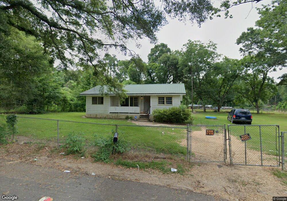
1002 Starnes Rd McComb, MS 39648
Estimated Value: $70,000 - $125,000
Studio
--
Bath
1,099
Sq Ft
$83/Sq Ft
Est. Value
About This Home
This home is located at 1002 Starnes Rd, McComb, MS 39648 and is currently estimated at $91,491, approximately $83 per square foot. 1002 Starnes Rd is a home with nearby schools including North Pike Elementary School, North Pike Middle School, and North Pike Senior High School.
Ownership History
Date
Name
Owned For
Owner Type
Purchase Details
Closed on
Sep 19, 2025
Sold by
Mcdaniel Hilton
Bought by
Beeson Theresa M
Current Estimated Value
Purchase Details
Closed on
Sep 12, 2018
Sold by
Pike National Bank
Bought by
Mcdaniel Hilton and Mcdaniel Mary
Purchase Details
Closed on
Mar 26, 2010
Sold by
Dillon Ouida Arickson and Reid Arickson Erma Lee
Bought by
Berberette Jennifer C and Curter Paul
Home Financials for this Owner
Home Financials are based on the most recent Mortgage that was taken out on this home.
Original Mortgage
$33,676
Interest Rate
4.93%
Mortgage Type
Purchase Money Mortgage
Create a Home Valuation Report for This Property
The Home Valuation Report is an in-depth analysis detailing your home's value as well as a comparison with similar homes in the area
Purchase History
| Date | Buyer | Sale Price | Title Company |
|---|---|---|---|
| Beeson Theresa M | -- | None Listed On Document | |
| Mcdaniel Hilton | -- | None Available | |
| Berberette Jennifer C | -- | None Available |
Source: Public Records
Mortgage History
| Date | Status | Borrower | Loan Amount |
|---|---|---|---|
| Previous Owner | Berberette Jennifer C | $33,676 |
Source: Public Records
Tax History
| Year | Tax Paid | Tax Assessment Tax Assessment Total Assessment is a certain percentage of the fair market value that is determined by local assessors to be the total taxable value of land and additions on the property. | Land | Improvement |
|---|---|---|---|---|
| 2025 | $596 | $4,400 | $0 | $0 |
| 2024 | $530 | $3,859 | $0 | $0 |
| 2023 | $519 | $3,859 | $0 | $0 |
| 2022 | $511 | $3,859 | $0 | $0 |
| 2021 | $510 | $3,859 | $0 | $0 |
| 2020 | $548 | $4,126 | $0 | $0 |
| 2019 | $534 | $4,126 | $0 | $0 |
| 2018 | $251 | $2,884 | $0 | $0 |
| 2017 | $243 | $2,884 | $0 | $0 |
| 2016 | $201 | $2,884 | $0 | $0 |
| 2015 | -- | $2,890 | $0 | $0 |
| 2014 | -- | $2,890 | $0 | $0 |
| 2013 | -- | $2,805 | $0 | $0 |
Source: Public Records
Map
Nearby Homes
- 0 Old 24 Hwy
- 1047 Lenoir Sellers Rd
- 730 Vogel St
- XXX US Highway 98
- 7153 US Highway 98
- 00 US Highway 98
- 1002 Pershing St
- X Wild Estate
- 823 Edgar St
- ... Berkshire Ln
- 505 S Magnolia St
- 425 S Broadway St
- 115 Scott St
- 429 21st St
- TBD Integrity Rd Lot #3
- 1208 Harper St
- 522 2nd St
- 0 Morgantown Rd Unit 4125975
- 707 Earl St
- 318 S Cherry St
- 1006 Starnes Rd
- 1005 Starnes Rd
- 2061 Berthadale Rd
- 2052 Berthadale Rd
- 2063 Berthadale Rd
- 1013 Starnes Rd
- 2057 Berthadale Rd
- 2055 Berthadale Rd
- 1015 Starnes Rd
- 1014 Starnes Rd
- 1018 Starnes Rd
- 2069 Berthadale Rd
- 00 Starnes Rd
- 1024 Starnes Rd
- 1025 Starnes Rd
- 1021 Starnes Rd
- 2074 Berthadale Rd
- 2059 Berthadale Rd
- 1026 Starnes Rd
- 1031 Starnes Rd
Your Personal Tour Guide
Ask me questions while you tour the home.