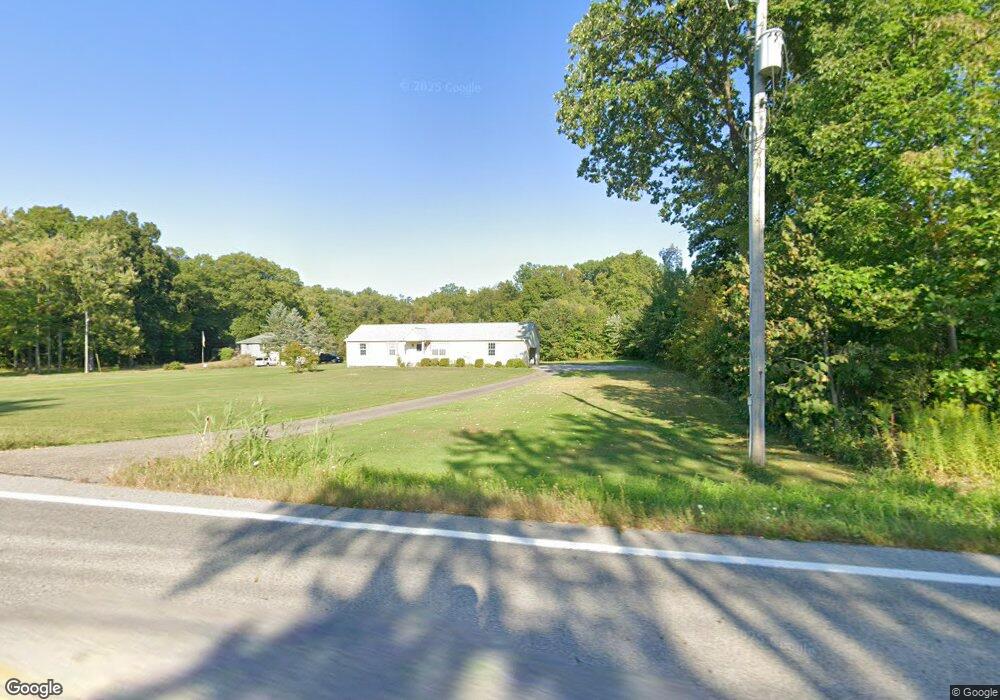
10026 State Route 700 Mantua, OH 44255
Estimated Value: $253,000 - $284,881
2
Beds
2
Baths
1,248
Sq Ft
$211/Sq Ft
Est. Value
About This Home
This home is located at 10026 State Route 700, Mantua, OH 44255 and is currently estimated at $263,220, approximately $210 per square foot. 10026 State Route 700 is a home located in Portage County with nearby schools including James A. Garfield Elementary School, James A. Garfield Middle School, and James A. Garfield High School.
Ownership History
Date
Name
Owned For
Owner Type
Purchase Details
Closed on
Aug 5, 2019
Sold by
Estate Of Sallie Hubeny
Bought by
Emslie Laura and Stewart Bradley
Current Estimated Value
Purchase Details
Closed on
May 3, 2005
Sold by
Phh Mortgage Corp
Bought by
Cortnik Carl L and Cortnik Paulette K
Purchase Details
Closed on
Feb 22, 2005
Sold by
King Gary
Bought by
Cendant Mortgage Corp
Create a Home Valuation Report for This Property
The Home Valuation Report is an in-depth analysis detailing your home's value as well as a comparison with similar homes in the area
Home Values in the Area
Average Home Value in this Area
Purchase History
| Date | Buyer | Sale Price | Title Company |
|---|---|---|---|
| Emslie Laura | -- | None Available | |
| Cortnik Carl L | -- | Accutitle Agency Inc | |
| Cendant Mortgage Corp | $23,334 | Accutitle Agency Inc |
Source: Public Records
Mortgage History
| Date | Status | Borrower | Loan Amount |
|---|---|---|---|
| Previous Owner | Cortnik Carl L | $35,000 |
Source: Public Records
Tax History Compared to Growth
Tax History
| Year | Tax Paid | Tax Assessment Tax Assessment Total Assessment is a certain percentage of the fair market value that is determined by local assessors to be the total taxable value of land and additions on the property. | Land | Improvement |
|---|---|---|---|---|
| 2024 | $2,923 | $86,460 | $13,410 | $73,050 |
| 2023 | $2,575 | $67,240 | $10,710 | $56,530 |
| 2022 | $2,578 | $67,240 | $10,710 | $56,530 |
| 2021 | $2,490 | $67,240 | $10,710 | $56,530 |
| 2020 | $2,177 | $57,690 | $10,190 | $47,500 |
| 2019 | $2,182 | $57,690 | $10,190 | $47,500 |
| 2018 | $2,246 | $51,040 | $10,190 | $40,850 |
| 2017 | $2,246 | $51,040 | $10,190 | $40,850 |
| 2016 | $2,170 | $51,040 | $10,190 | $40,850 |
| 2015 | $2,183 | $51,040 | $10,190 | $40,850 |
| 2014 | $2,219 | $51,040 | $10,190 | $40,850 |
| 2013 | $2,309 | $51,040 | $10,190 | $40,850 |
Source: Public Records
Map
Nearby Homes
- 6994 Hankee Rd
- 10018 Nichols Rd
- 6847 State Route 303
- 7000 Village Way Dr
- 7050 Village Way Dr
- 7076 Village Way Dr
- 10685 Limeridge Rd
- 10729 Forest St
- 7761 Ohio 303
- 7795 Ohio 303
- 11383 Rolling Meadows Dr
- 8026 Elm St
- V/L State St
- 10977 Fox Hollow Dr
- VL Ohio 82
- 0 Ohio 82
- Lot 7 Wheeler Rd
- Lot 14 Wheeler Rd
- 6846 Wakefield Rd
- SR 82 Ohio 82
- 10040 State Route 700
- 9979 State Route 700
- 9966 State Route 700
- 9967 Ohio 700
- 9967 State Route 700
- 10039 Ohio 700 Unit 125
- 10039 Ohio 700 Unit 112
- 10039 Ohio 700 Unit 119
- 10039 State Route 700 Unit 22
- 10039 State Route 700 Unit 109
- 10039 State Route 700 Unit 30
- 10039 State Route 700 Unit 97
- 10039 State Route 700 Unit 36
- 10039 State Route 700
- 10039 State Route 700 Unit Lot 118
- 10039 State Route 700 Unit Lot 12
- 10039 State Route 700 Unit Lot 114
- 10039 State Route 700 Unit 44
- 9992 State Route 700
- 10039 St Rt 700 Lot#111