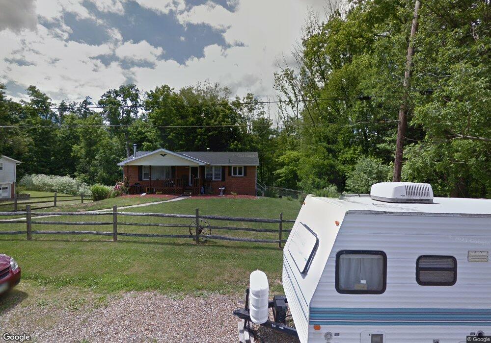
1004 Marianna Dr Mansfield, OH 44903
Estimated Value: $187,000 - $229,000
3
Beds
1
Bath
1,232
Sq Ft
$162/Sq Ft
Est. Value
About This Home
This home is located at 1004 Marianna Dr, Mansfield, OH 44903 and is currently estimated at $199,250, approximately $161 per square foot. 1004 Marianna Dr is a home located in Richland County.
Ownership History
Date
Name
Owned For
Owner Type
Purchase Details
Closed on
Jul 22, 2016
Sold by
Boyd Amelia B
Bought by
Marchak Sara A
Current Estimated Value
Home Financials for this Owner
Home Financials are based on the most recent Mortgage that was taken out on this home.
Original Mortgage
$81,000
Outstanding Balance
$53,616
Interest Rate
3.54%
Mortgage Type
Unknown
Estimated Equity
$145,634
Purchase Details
Closed on
Dec 7, 2012
Sold by
Cornell Cody W
Bought by
Boyd Amelia B
Home Financials for this Owner
Home Financials are based on the most recent Mortgage that was taken out on this home.
Original Mortgage
$61,600
Interest Rate
3.38%
Mortgage Type
Future Advance Clause Open End Mortgage
Purchase Details
Closed on
Oct 26, 2010
Sold by
Ward Richard E and Ward Linda M
Bought by
Cornell Cody W
Home Financials for this Owner
Home Financials are based on the most recent Mortgage that was taken out on this home.
Original Mortgage
$68,507
Interest Rate
5.5%
Mortgage Type
FHA
Create a Home Valuation Report for This Property
The Home Valuation Report is an in-depth analysis detailing your home's value as well as a comparison with similar homes in the area
Home Values in the Area
Average Home Value in this Area
Purchase History
| Date | Buyer | Sale Price | Title Company |
|---|---|---|---|
| Marchak Sara A | $90,000 | Southern Title | |
| Boyd Amelia B | $68,500 | Chicago Title | |
| Cornell Cody W | $69,500 | Barrister |
Source: Public Records
Mortgage History
| Date | Status | Borrower | Loan Amount |
|---|---|---|---|
| Open | Marchak Sara A | $81,000 | |
| Previous Owner | Boyd Amelia B | $61,600 | |
| Previous Owner | Cornell Cody W | $68,507 |
Source: Public Records
Tax History Compared to Growth
Tax History
| Year | Tax Paid | Tax Assessment Tax Assessment Total Assessment is a certain percentage of the fair market value that is determined by local assessors to be the total taxable value of land and additions on the property. | Land | Improvement |
|---|---|---|---|---|
| 2024 | $1,996 | $41,170 | $7,270 | $33,900 |
| 2023 | $1,996 | $41,170 | $7,270 | $33,900 |
| 2022 | $1,895 | $34,710 | $6,500 | $28,210 |
| 2021 | $1,894 | $34,710 | $6,500 | $28,210 |
| 2020 | $1,909 | $34,710 | $6,500 | $28,210 |
| 2019 | $1,820 | $29,420 | $5,510 | $23,910 |
| 2018 | $1,701 | $29,420 | $5,510 | $23,910 |
| 2017 | $1,666 | $29,420 | $5,510 | $23,910 |
| 2016 | $1,418 | $24,200 | $5,040 | $19,160 |
| 2015 | $1,418 | $24,200 | $5,040 | $19,160 |
| 2014 | $1,347 | $24,200 | $5,040 | $19,160 |
| 2012 | $669 | $25,440 | $5,270 | $20,170 |
Source: Public Records
Map
Nearby Homes
- 929 Antionette Dr
- 0 State Route 39 & I-71 Southeast Quadrant
- 0 State Route 39 & I-71 Northeast Quadrant
- 1875 Mansfield Lucas Rd
- 1679 Pulver Rd
- 794 Mansfield Washington Rd
- 716 Mansfield Washington Rd
- 0 Woodville Rd Unit Lot 14952, 14953
- 0 Woodville Rd Unit Lot 14954, 14955
- 0 Woodville Rd Unit Lot 14956, 14957,
- 36 Ridge Rd S
- 369 Davidson St
- 2061 Washington North Rd
- 0 Mcelroy Rd
- 419 Pearl Ave
- 405 Plainview Ave
- 953 Park Ave E
- 62 Bahl Ave
- 155 Ford Rd N Unit Lot 30
- 155 Ford Rd N
- 1012 Marianna Dr
- 1020 Marianna Dr
- 1005 Marianna Dr
- 1070 Marianna Dr
- 1026 Marianna Dr
- 1021 Marianna Dr
- 1030 Marianna Dr
- 1031 Marianna Dr
- 1040 Marianna Dr
- 1051 Marianna Dr
- 940 Moritz Ln
- 1052 Marianna Dr
- 1065 Marianna Dr
- 1066 Marianna Dr
- 1075 Marianna Dr
- 980 Moritz Ln
- 1076 Marianna Dr
- 1085 Marianna Dr Unit 1087
- 1087 Marianna Dr
- 1088 Marianna Dr