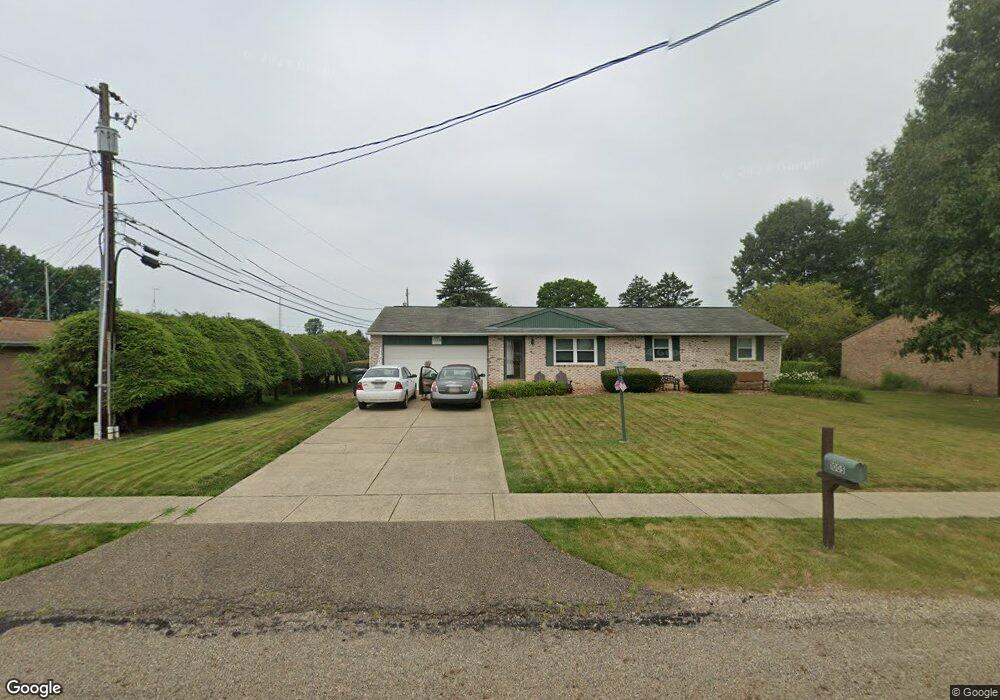
1005 Hazel Ave Louisville, OH 44641
Estimated Value: $221,400 - $259,000
3
Beds
3
Baths
1,144
Sq Ft
$210/Sq Ft
Est. Value
About This Home
This home is located at 1005 Hazel Ave, Louisville, OH 44641 and is currently estimated at $240,100, approximately $209 per square foot. 1005 Hazel Ave is a home located in Stark County with nearby schools including Louisville High School and St. Thomas Aquinas High School & Middle School.
Ownership History
Date
Name
Owned For
Owner Type
Purchase Details
Closed on
Aug 13, 2008
Sold by
Kuehn Jeffrey W and Kuehn Lisa J
Bought by
Anderson Alice M
Current Estimated Value
Home Financials for this Owner
Home Financials are based on the most recent Mortgage that was taken out on this home.
Original Mortgage
$40,050
Outstanding Balance
$9,429
Interest Rate
6.39%
Mortgage Type
Purchase Money Mortgage
Estimated Equity
$230,671
Purchase Details
Closed on
Oct 18, 2000
Sold by
Wolf Robert P
Bought by
Kuehn Jeffery W and Cargill Lisa J
Create a Home Valuation Report for This Property
The Home Valuation Report is an in-depth analysis detailing your home's value as well as a comparison with similar homes in the area
Home Values in the Area
Average Home Value in this Area
Purchase History
| Date | Buyer | Sale Price | Title Company |
|---|---|---|---|
| Anderson Alice M | $144,900 | Real Living Title Agency Ltd | |
| Kuehn Jeffery W | $117,000 | -- |
Source: Public Records
Mortgage History
| Date | Status | Borrower | Loan Amount |
|---|---|---|---|
| Open | Anderson Alice M | $40,050 |
Source: Public Records
Tax History Compared to Growth
Tax History
| Year | Tax Paid | Tax Assessment Tax Assessment Total Assessment is a certain percentage of the fair market value that is determined by local assessors to be the total taxable value of land and additions on the property. | Land | Improvement |
|---|---|---|---|---|
| 2025 | -- | $59,440 | $15,020 | $44,420 |
| 2024 | -- | $59,440 | $15,020 | $44,420 |
| 2023 | $1,985 | $55,340 | $14,140 | $41,200 |
| 2022 | $2,008 | $55,340 | $14,140 | $41,200 |
| 2021 | $2,014 | $55,340 | $14,140 | $41,200 |
| 2020 | $1,629 | $49,670 | $12,740 | $36,930 |
| 2019 | $1,636 | $49,670 | $12,740 | $36,930 |
| 2018 | $1,629 | $49,670 | $12,740 | $36,930 |
| 2017 | $1,459 | $44,100 | $11,200 | $32,900 |
| 2016 | $1,489 | $44,100 | $11,200 | $32,900 |
| 2015 | $1,493 | $44,100 | $11,200 | $32,900 |
| 2014 | $1,335 | $38,120 | $9,700 | $28,420 |
| 2013 | $671 | $38,120 | $9,700 | $28,420 |
Source: Public Records
Map
Nearby Homes
- 1715 High St
- 1812 E Broad St
- 641 S Nickelplate St
- 2110 Edmar St
- 520 S Silver St
- 308 Superior St
- 728 E Broad St
- 908 Sand Lot Cir
- 0 Michigan Blvd
- 510 S Bauman Ct
- 204 E Broad St
- 2015 E Main St
- 107 E Broad St
- 3390 Meese Rd NE
- 325 Lincoln Ave
- 1702 View Pointe Ave
- 1639 Horizon Dr
- 1170 Winding Ridge Ave
- 8225 Georgetown St
- 910 Crosswyck Cir