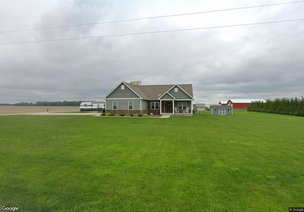
1005 Leonard Rd Covington, OH 45318
Estimated Value: $455,000 - $593,000
3
Beds
3
Baths
2,498
Sq Ft
$200/Sq Ft
Est. Value
About This Home
This home is located at 1005 Leonard Rd, Covington, OH 45318 and is currently estimated at $500,778, approximately $200 per square foot. 1005 Leonard Rd is a home located in Miami County with nearby schools including Newton Elementary School and Newton High School.
Ownership History
Date
Name
Owned For
Owner Type
Purchase Details
Closed on
Oct 9, 2017
Sold by
Summit Builders Llc
Bought by
Dick John M and Dick Melissa J
Current Estimated Value
Home Financials for this Owner
Home Financials are based on the most recent Mortgage that was taken out on this home.
Original Mortgage
$248,200
Outstanding Balance
$204,572
Interest Rate
3.78%
Mortgage Type
New Conventional
Estimated Equity
$296,206
Purchase Details
Closed on
Jul 13, 2016
Sold by
Miller Pamela J
Bought by
Summit Builders Llc
Purchase Details
Closed on
Apr 6, 2006
Sold by
Miller Randy L
Bought by
Miller Pamela
Purchase Details
Closed on
Aug 5, 2004
Sold by
Deeter Christopher N
Bought by
Chase Manhattan Mortgage Corp
Purchase Details
Closed on
May 21, 2004
Sold by
Deeter Christopher
Bought by
Hud
Purchase Details
Closed on
Jan 1, 1990
Bought by
Deeter Opal Ellen
Create a Home Valuation Report for This Property
The Home Valuation Report is an in-depth analysis detailing your home's value as well as a comparison with similar homes in the area
Purchase History
| Date | Buyer | Sale Price | Title Company |
|---|---|---|---|
| Dick John M | $25,000 | -- | |
| Summit Builders Llc | $20,000 | First Title | |
| Miller Pamela | -- | -- | |
| Chase Manhattan Mortgage Corp | $62,000 | -- | |
| Hud | -- | -- | |
| Deeter Opal Ellen | -- | -- |
Source: Public Records
Mortgage History
| Date | Status | Borrower | Loan Amount |
|---|---|---|---|
| Open | Dick John M | $248,200 |
Source: Public Records
Tax History
| Year | Tax Paid | Tax Assessment Tax Assessment Total Assessment is a certain percentage of the fair market value that is determined by local assessors to be the total taxable value of land and additions on the property. | Land | Improvement |
|---|---|---|---|---|
| 2025 | $5,723 | $163,600 | $11,940 | $151,660 |
| 2024 | $5,723 | $113,860 | $8,680 | $105,180 |
| 2023 | $4,169 | $113,860 | $8,680 | $105,180 |
| 2022 | $4,235 | $113,860 | $8,680 | $105,180 |
| 2021 | $3,772 | $94,890 | $7,250 | $87,640 |
| 2020 | $3,782 | $94,890 | $7,250 | $87,640 |
| 2019 | $3,480 | $93,420 | $7,250 | $86,170 |
| 2018 | $2,377 | $62,200 | $7,180 | $55,020 |
| 2017 | $189 | $4,900 | $4,900 | $0 |
| 2016 | $187 | $4,900 | $4,900 | $0 |
| 2015 | $96 | $2,280 | $2,280 | $0 |
| 2014 | $96 | $2,280 | $2,280 | $0 |
| 2013 | $97 | $2,280 | $2,280 | $0 |
Source: Public Records
Map
Nearby Homes
- 1005 N Leonard Rd
- 1045 Leonard Rd
- 9693 W State Route 718
- 9710 W State Route 718
- 9637 W State Route 718
- 1091 Leonard Rd
- 9835 W State Route 718
- 9500 W State Route 718
- 9590 W State Route 718
- 9740 W State Route 718
- 9820 W State Route 718
- 9980 W State Route 718
- 1192 Leonard Rd
- 9980 St Rt 718 W
- 1000 N Rangeline Rd
- 1122 N Rangeline Rd
- 930 N Rangeline Rd
- 1095 N Rangeline Rd
- 910 N Rangeline Rd
- 10121 W State Route 718
Your Personal Tour Guide
Ask me questions while you tour the home.