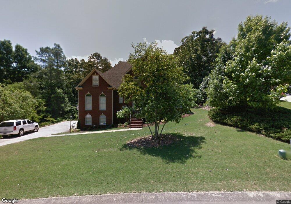
1005 Molay Cir Birmingham, AL 35242
Estimated Value: $557,000 - $624,000
Studio
3
Baths
3,418
Sq Ft
$172/Sq Ft
Est. Value
About This Home
This home is located at 1005 Molay Cir, Birmingham, AL 35242 and is currently estimated at $589,014, approximately $172 per square foot. 1005 Molay Cir is a home located in Shelby County with nearby schools including Inverness Elementary School, Oak Mountain Intermediate School, and Oak Mt. Middle School.
Ownership History
Date
Name
Owned For
Owner Type
Purchase Details
Closed on
Jan 11, 2013
Sold by
Kiousis Barbara Anne
Bought by
Dimick Daniel B and Dimick Mary Jean
Current Estimated Value
Home Financials for this Owner
Home Financials are based on the most recent Mortgage that was taken out on this home.
Original Mortgage
$272,000
Outstanding Balance
$188,945
Interest Rate
3.35%
Mortgage Type
New Conventional
Estimated Equity
$400,069
Purchase Details
Closed on
Feb 2, 2006
Sold by
Kiousis Michael N
Bought by
Kiousis Barbara Anne
Purchase Details
Closed on
Oct 30, 1998
Sold by
Conklin Donald J and Conklin Theresa A
Bought by
Kiousis Michael N and Kiousis Barbara Anne
Home Financials for this Owner
Home Financials are based on the most recent Mortgage that was taken out on this home.
Original Mortgage
$254,600
Interest Rate
6.25%
Create a Home Valuation Report for This Property
The Home Valuation Report is an in-depth analysis detailing your home's value as well as a comparison with similar homes in the area
Home Values in the Area
Average Home Value in this Area
Purchase History
| Date | Buyer | Sale Price | Title Company |
|---|---|---|---|
| Dimick Daniel B | $340,000 | None Available | |
| Kiousis Barbara Anne | -- | None Available | |
| Kiousis Michael N | $268,000 | -- |
Source: Public Records
Mortgage History
| Date | Status | Borrower | Loan Amount |
|---|---|---|---|
| Open | Dimick Daniel B | $272,000 | |
| Previous Owner | Kiousis Michael N | $254,600 |
Source: Public Records
Tax History
| Year | Tax Paid | Tax Assessment Tax Assessment Total Assessment is a certain percentage of the fair market value that is determined by local assessors to be the total taxable value of land and additions on the property. | Land | Improvement |
|---|---|---|---|---|
| 2024 | $2,117 | $48,120 | $0 | $0 |
| 2023 | $1,907 | $44,280 | $0 | $0 |
| 2022 | $1,811 | $42,080 | $0 | $0 |
| 2021 | $1,651 | $38,460 | $0 | $0 |
| 2020 | $1,679 | $39,100 | $0 | $0 |
| 2019 | $1,678 | $39,060 | $0 | $0 |
| 2017 | $1,619 | $37,720 | $0 | $0 |
| 2015 | $1,540 | $35,940 | $0 | $0 |
| 2014 | $1,502 | $35,060 | $0 | $0 |
Source: Public Records
Map
Nearby Homes
- 5211 Post House Ln
- 5206 Post House Ln
- 4917 Keith Dr
- 4905 Keith Dr
- 5113 S Broken Bow Dr
- 3113 Bradford Place
- 2712 Drennen Cir
- 4826 Keith Dr
- 5621 Double Tree Cir
- 5104 Meadow Brook Rd
- 557 Thorn Berry Ln
- 4914 Valleydale Rd
- 132 Thorn Berry Dr
- 1014 Windsor Dr
- 5243 Harvest Ridge Ln
- 129 Biltmore Dr
- 3020 Brookhill Dr
- 5204 Harvest Ridge Ln
- 2905 Macalpine Cir
- 2909 Macalpine Cir
- 1001 Molay Cir
- 2098 Forest Meadows Cir
- 5453 Sunrise Dr
- 5449 Sunrise Dr
- 1008 Molay Cir
- 3012 Forest Meadows Cir
- 5457 Sunrise Dr
- 1015 Molay Cir
- 5445 Sunrise Dr
- 1012 Molay Cir
- 2094 Forest Meadows Cir
- 5461 Sunrise Dr
- 3009 Forest Meadows Cir
- 3003 Forest Meadows Cir
- 2099 Forest Meadows Cir
- 5441 Sunrise Dr
- 3018 Forest Meadows Cir
- 1008 Forest Meadows Dr
- 2095 Forest Meadows Cir
- 1004 Forest Meadows Dr
Your Personal Tour Guide
Ask me questions while you tour the home.