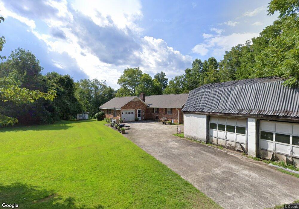
1005 Sammie Ln Lenoir, NC 28645
Estimated Value: $264,000 - $348,000
3
Beds
2
Baths
1,740
Sq Ft
$177/Sq Ft
Est. Value
About This Home
This home is located at 1005 Sammie Ln, Lenoir, NC 28645 and is currently estimated at $308,029, approximately $177 per square foot. 1005 Sammie Ln is a home located in Caldwell County with nearby schools including Oak Hill Elementary, Dudley Shoals Elementary School, and William Lenoir Middle School.
Ownership History
Date
Name
Owned For
Owner Type
Purchase Details
Closed on
Jul 27, 2011
Sold by
Greene David Timothy and Greene Brandy H
Bought by
Greene David Timothy and Greene Brandy H
Current Estimated Value
Home Financials for this Owner
Home Financials are based on the most recent Mortgage that was taken out on this home.
Original Mortgage
$40,000
Interest Rate
4.53%
Mortgage Type
New Conventional
Create a Home Valuation Report for This Property
The Home Valuation Report is an in-depth analysis detailing your home's value as well as a comparison with similar homes in the area
Home Values in the Area
Average Home Value in this Area
Purchase History
| Date | Buyer | Sale Price | Title Company |
|---|---|---|---|
| Greene David Timothy | -- | None Available |
Source: Public Records
Mortgage History
| Date | Status | Borrower | Loan Amount |
|---|---|---|---|
| Closed | Greene David Timothy | $40,000 |
Source: Public Records
Tax History Compared to Growth
Tax History
| Year | Tax Paid | Tax Assessment Tax Assessment Total Assessment is a certain percentage of the fair market value that is determined by local assessors to be the total taxable value of land and additions on the property. | Land | Improvement |
|---|---|---|---|---|
| 2025 | $1,368 | $270,700 | $33,300 | $237,400 |
| 2024 | $1,368 | $170,300 | $28,200 | $142,100 |
| 2023 | $1,317 | $170,300 | $28,200 | $142,100 |
| 2022 | $1,292 | $170,300 | $28,200 | $142,100 |
| 2021 | $1,292 | $170,300 | $28,200 | $142,100 |
| 2020 | $1,190 | $153,100 | $27,300 | $125,800 |
| 2019 | $1,145 | $153,100 | $27,300 | $125,800 |
| 2018 | $1,175 | $153,100 | $0 | $0 |
| 2017 | $1,175 | $153,100 | $0 | $0 |
| 2016 | $1,173 | $153,100 | $0 | $0 |
| 2015 | $1,097 | $153,100 | $0 | $0 |
| 2014 | $1,097 | $153,100 | $0 | $0 |
Source: Public Records
Map
Nearby Homes
- 0000 Sheriffs Rd
- 000 Union Baptist Rd
- Sheriff's Rd
- 0 Union Baptist Rd Unit 2 CAR4293069
- 0 Union Baptist Rd Unit 1 CAR4291121
- 2660 Taylorsville Rd
- 3086 Taylorsville Rd
- 1277 Brush Mountain Rd
- 2910 Taylorsville Rd
- 4375 Fox Rd
- 1154 Woodrow Place
- 0 Scout Rd
- 3750 Rabbits Run Place
- 7227 & 7229 N Carolina 90
- Lot 1 McRary Creek Rd
- 3325 Eagle Heights Cir
- 0 McRary Creek Rd Unit 1 CAR4301960
- 2482 Holman Ridge Ct
- 1533 McCrary Creek Rd
- 1533 McRary Creek Rd
- 5471 Sheriffs Rd
- 5470 Sheriffs Rd
- 5438 Sheriffs Rd
- 5481 Sheriffs Rd
- 5411 Sheriffs Rd
- 5434 Sheriffs Rd
- 5485 Sheriffs Rd
- 1024 Sammie Ln
- 5412 Sheriffs Rd
- 5497 Sheriffs Rd
- 5399 Sheriffs Rd
- 5430 Sheriffs Rd
- 5499 Sheriffs Rd
- 5390 Sheriffs Rd
- 5512 Sheriffs Rd
- 5530 Sheriffs Rd
- 5535 Sheriffs Rd
- 5496 Sheriffs Rd
- 5541 Sheriffs Rd
- 5357 Sheriffs Rd