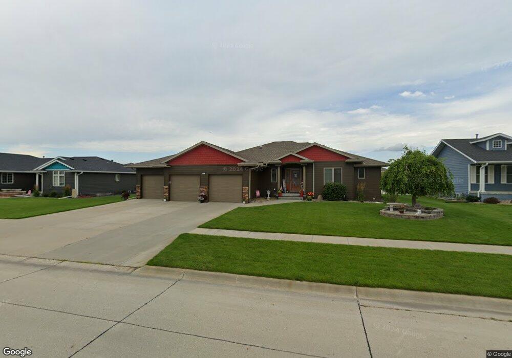
1005 Westbrook Dr Norfolk, NE 68701
Estimated Value: $432,626 - $480,000
3
Beds
5
Baths
1,810
Sq Ft
$249/Sq Ft
Est. Value
About This Home
This home is located at 1005 Westbrook Dr, Norfolk, NE 68701 and is currently estimated at $450,157, approximately $248 per square foot. 1005 Westbrook Dr is a home located in Madison County with nearby schools including Norfolk Senior High School, Keystone Christian Academy, and Park Avenue Christian School.
Ownership History
Date
Name
Owned For
Owner Type
Purchase Details
Closed on
Jan 6, 2009
Sold by
Walters Wayne L
Bought by
Korth Mark W and Korth Kathleen M
Current Estimated Value
Home Financials for this Owner
Home Financials are based on the most recent Mortgage that was taken out on this home.
Original Mortgage
$175,000
Outstanding Balance
$85,950
Interest Rate
5.48%
Mortgage Type
New Conventional
Estimated Equity
$364,207
Create a Home Valuation Report for This Property
The Home Valuation Report is an in-depth analysis detailing your home's value as well as a comparison with similar homes in the area
Home Values in the Area
Average Home Value in this Area
Purchase History
| Date | Buyer | Sale Price | Title Company |
|---|---|---|---|
| Korth Mark W | $225,000 | -- | |
| Korth Mark W | $225,000 | None Available |
Source: Public Records
Mortgage History
| Date | Status | Borrower | Loan Amount |
|---|---|---|---|
| Open | Korth Mark W | $175,000 |
Source: Public Records
Tax History Compared to Growth
Tax History
| Year | Tax Paid | Tax Assessment Tax Assessment Total Assessment is a certain percentage of the fair market value that is determined by local assessors to be the total taxable value of land and additions on the property. | Land | Improvement |
|---|---|---|---|---|
| 2024 | $4,378 | $350,933 | $32,799 | $318,134 |
| 2023 | $5,848 | $316,299 | $21,319 | $294,980 |
| 2022 | $5,458 | $294,449 | $21,319 | $273,130 |
| 2021 | $5,117 | $276,581 | $21,319 | $255,262 |
| 2020 | $5,101 | $276,581 | $21,319 | $255,262 |
| 2019 | $4,922 | $257,673 | $21,319 | $236,354 |
| 2018 | $4,636 | $246,808 | $21,319 | $225,489 |
| 2017 | $4,335 | $230,508 | $21,319 | $209,189 |
| 2016 | $4,190 | $222,358 | $21,319 | $201,039 |
| 2015 | $4,191 | $222,358 | $21,319 | $201,039 |
| 2014 | $4,316 | $222,358 | $21,319 | $201,039 |
| 2013 | $4,456 | $222,358 | $21,319 | $201,039 |
Source: Public Records
Map
Nearby Homes
- 1003 Westbrook Dr
- 1007 Westbrook Dr
- 1714 E Sycamore Ave
- 1712 E Sycamore Ave
- 1004 Westbrook Dr
- 1710 E Sycamore Ave
- 1002 Westbrook Dr
- 1001 Westbrook Dr
- 1006 Westbrook Dr
- 1000 Westbrook Dr
- 1715 E Sycamore Ave
- 1100 Westbrook Dr
- 1708 E Sycamore Ave
- 1008 Westbrook Dr
- 1713 E Sycamore Ave
- 909 Westbrook Dr
- 1717 E Sycamore Ave
- 1102 Westbrook Dr
- 1711 E Sycamore Ave
- 906 Westbrook Dr