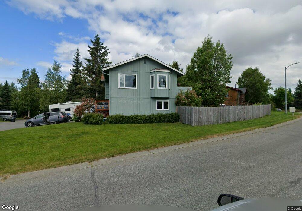
10053 Nantucket Cir Anchorage, AK 99507
Abbott Loop NeighborhoodEstimated Value: $410,693 - $586,000
3
Beds
2
Baths
1,538
Sq Ft
$309/Sq Ft
Est. Value
About This Home
This home is located at 10053 Nantucket Cir, Anchorage, AK 99507 and is currently estimated at $475,423, approximately $309 per square foot. 10053 Nantucket Cir is a home located in Anchorage Municipality with nearby schools including Spring Hill Elementary School, Hanshew Middle School, and Service High School.
Ownership History
Date
Name
Owned For
Owner Type
Purchase Details
Closed on
Jan 8, 2009
Sold by
Summerville Jeffrey C and Summerville Maryjane
Bought by
Knight Kevin and Knight Melissa
Current Estimated Value
Home Financials for this Owner
Home Financials are based on the most recent Mortgage that was taken out on this home.
Original Mortgage
$251,750
Outstanding Balance
$165,717
Interest Rate
5.97%
Mortgage Type
Purchase Money Mortgage
Estimated Equity
$309,706
Create a Home Valuation Report for This Property
The Home Valuation Report is an in-depth analysis detailing your home's value as well as a comparison with similar homes in the area
Home Values in the Area
Average Home Value in this Area
Purchase History
| Date | Buyer | Sale Price | Title Company |
|---|---|---|---|
| Knight Kevin | -- | Pnt |
Source: Public Records
Mortgage History
| Date | Status | Borrower | Loan Amount |
|---|---|---|---|
| Open | Knight Kevin | $251,750 |
Source: Public Records
Tax History Compared to Growth
Tax History
| Year | Tax Paid | Tax Assessment Tax Assessment Total Assessment is a certain percentage of the fair market value that is determined by local assessors to be the total taxable value of land and additions on the property. | Land | Improvement |
|---|---|---|---|---|
| 2025 | $4,739 | $395,200 | $99,400 | $295,800 |
| 2024 | $4,739 | $368,500 | $99,400 | $269,100 |
| 2023 | $5,795 | $340,300 | $99,400 | $240,900 |
| 2022 | $4,606 | $323,500 | $99,400 | $224,100 |
| 2021 | $5,323 | $295,400 | $99,400 | $196,000 |
| 2020 | $4,233 | $299,300 | $99,400 | $199,900 |
| 2019 | $3,971 | $292,700 | $99,400 | $193,300 |
| 2018 | $3,826 | $283,300 | $95,400 | $187,900 |
| 2017 | $4,319 | $295,800 | $95,400 | $200,400 |
| 2016 | $3,639 | $284,300 | $91,800 | $192,500 |
| 2015 | $3,639 | $275,500 | $91,800 | $183,700 |
| 2014 | $3,639 | $271,200 | $91,800 | $179,400 |
Source: Public Records
Map
Nearby Homes
- 2060 Sturbridge Cir
- 8000 Independence Park Dr
- 10359 Valley Park Dr
- 1914 Sturbridge Ct Unit 3
- 10260 Jamestown Dr Unit A8
- 1900-1941 Marthas Vineyard Cir
- 1917 Colony Place Unit 33
- 9730 Vanguard Dr Unit 12
- 9710 Vanguard Dr Unit 80
- 9700 Vanguard Dr Unit 70
- 10261 Arborvitae Dr
- 10285 Arborvitae Dr
- 1611 Betula Cir
- 9599 Brayton Dr Unit 422
- 1510 Elcadore Dr Unit 134
- 1540 Elcadore Dr Unit 125
- 267 Loop Unit 267
- 9130 Golovin St
- 10009 Thimble Berry Dr
- 10412 Thimble Berry Dr
- 10047 Nantucket Cir
- 2330 Colony Loop
- 10043 Nantucket Cir
- 10101 Nantucket Loop
- 2310 Yorktown Cir
- 10052 Nantucket Cir
- 10048 Nantucket Cir
- 2320 Colony Loop
- 10105 Nantucket Loop
- 10031 Nantucket Cir
- 10042 Nantucket Cir
- 10037 Nantucket Cir
- 2320 Yorktown Cir
- 2311 Yorktown Cir
- 10100 Nantucket Loop
- 10111 Nantucket Loop
- 2310 Colony Loop
- 10025 Nantucket Cir
- 10026 Nantucket Cir
- 10036 Nantucket Cir