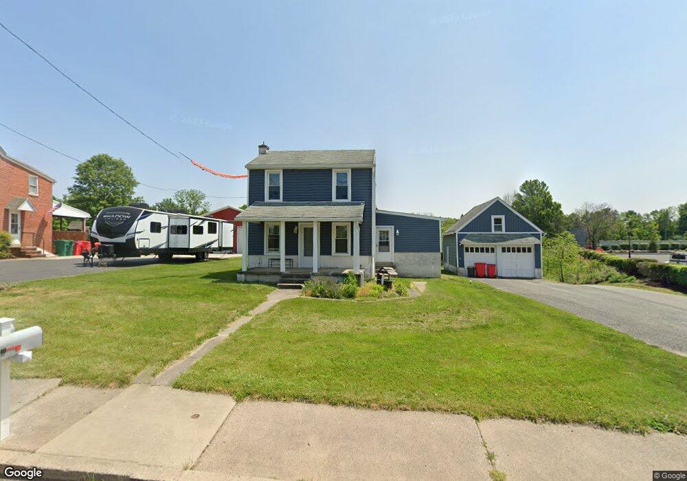
1008 Grosstown Rd Pottstown, PA 19464
Estimated Value: $275,000 - $314,000
3
Beds
1
Bath
1,368
Sq Ft
$215/Sq Ft
Est. Value
About This Home
This home is located at 1008 Grosstown Rd, Pottstown, PA 19464 and is currently estimated at $294,581, approximately $215 per square foot. 1008 Grosstown Rd is a home located in Montgomery County with nearby schools including Lower Pottsgrove Elementary School, Pottsgrove Middle School, and Pottsgrove Senior High School.
Ownership History
Date
Name
Owned For
Owner Type
Purchase Details
Closed on
Oct 28, 2005
Sold by
Freese Michael E and Freese Mandi M
Bought by
Petrikis Stanley and Petrikis Jill
Current Estimated Value
Home Financials for this Owner
Home Financials are based on the most recent Mortgage that was taken out on this home.
Original Mortgage
$131,920
Outstanding Balance
$71,795
Interest Rate
5.93%
Estimated Equity
$222,786
Purchase Details
Closed on
Dec 2, 2004
Sold by
Hennessey Joseph G and Hennessey Angela S
Bought by
Freese Michael E and Freese Mandi M
Home Financials for this Owner
Home Financials are based on the most recent Mortgage that was taken out on this home.
Original Mortgage
$100,000
Interest Rate
5.68%
Purchase Details
Closed on
May 27, 1999
Sold by
Dicarlo David R and Dicarlo Anita J Gambino
Bought by
Hennessey Joseph G and Freese Angela S
Create a Home Valuation Report for This Property
The Home Valuation Report is an in-depth analysis detailing your home's value as well as a comparison with similar homes in the area
Home Values in the Area
Average Home Value in this Area
Purchase History
| Date | Buyer | Sale Price | Title Company |
|---|---|---|---|
| Petrikis Stanley | $164,900 | -- | |
| Freese Michael E | -- | -- | |
| Hennessey Joseph G | $75,000 | -- |
Source: Public Records
Mortgage History
| Date | Status | Borrower | Loan Amount |
|---|---|---|---|
| Open | Petrikis Stanley | $131,920 | |
| Previous Owner | Freese Michael E | $100,000 |
Source: Public Records
Tax History Compared to Growth
Tax History
| Year | Tax Paid | Tax Assessment Tax Assessment Total Assessment is a certain percentage of the fair market value that is determined by local assessors to be the total taxable value of land and additions on the property. | Land | Improvement |
|---|---|---|---|---|
| 2025 | $3,789 | $78,860 | $34,710 | $44,150 |
| 2024 | $3,789 | $78,860 | $34,710 | $44,150 |
| 2023 | $3,669 | $78,860 | $34,710 | $44,150 |
| 2022 | $3,611 | $78,860 | $34,710 | $44,150 |
| 2021 | $3,558 | $78,860 | $34,710 | $44,150 |
| 2020 | $3,505 | $78,860 | $34,710 | $44,150 |
| 2019 | $3,487 | $78,860 | $34,710 | $44,150 |
| 2018 | $3,487 | $78,860 | $34,710 | $44,150 |
| 2017 | $3,475 | $78,860 | $34,710 | $44,150 |
| 2016 | $3,444 | $78,860 | $34,710 | $44,150 |
| 2015 | $3,325 | $78,860 | $34,710 | $44,150 |
| 2014 | $3,325 | $78,860 | $34,710 | $44,150 |
Source: Public Records
Map
Nearby Homes
- 1209 Grosstown Rd
- 104 Pulaski St
- 160 Linden St Unit 69
- 377 Circle of Progress Dr
- 530 E Howard St
- 703 Holly Dr
- 501 and 507 E Race St
- 8 Ryan St
- 1405 Old Glasgow St
- 129 Rattlesnake Hill Rd
- 356 W Beech St Unit 160
- 666 Manatawny St
- 601 W High St
- 443 Manatawny St
- 551 Upland St
- 536 & 538 W Vine St
- 94 Random Rd
- 25 Random Rd
- 60 W 3rd St
- 559 Belmont St
- 1016 Grosstown Rd
- 1012 Grosstown Rd
- 1005 Grosstown Rd
- 1018 Grosstown Rd
- 1011 Grosstown Rd
- 1020 Grosstown Rd
- 974 Grosstown Rd
- 977 Grosstown Rd
- 969 Grosstown Rd
- 968 Grosstown Rd
- 1025 Grosstown Rd
- 1032 Grosstown Rd
- 1000 Grosstown Rd
- 635 Morello Dr
- 963 Grosstown Rd
- 1052 Acorn Way
- 1033 Grosstown Rd
- 962 Grosstown Rd
- 28A Candelora Dr
- 1040 Grosstown Rd