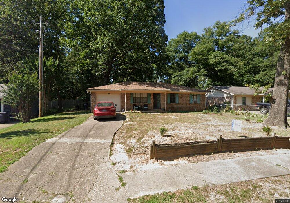
1008 Liberty Dr Jacksonville, AR 72076
Estimated Value: $117,755 - $129,000
3
Beds
2
Baths
1,121
Sq Ft
$110/Sq Ft
Est. Value
About This Home
This home is located at 1008 Liberty Dr, Jacksonville, AR 72076 and is currently estimated at $123,689, approximately $110 per square foot. 1008 Liberty Dr is a home located in Pulaski County with nearby schools including Murrell Taylor Elementary School, Jacksonville Middle School, and Jacksonville High School.
Ownership History
Date
Name
Owned For
Owner Type
Purchase Details
Closed on
Jun 12, 2003
Sold by
Johnson George Olin
Bought by
Clark David T
Current Estimated Value
Home Financials for this Owner
Home Financials are based on the most recent Mortgage that was taken out on this home.
Original Mortgage
$68,918
Outstanding Balance
$29,707
Interest Rate
5.56%
Mortgage Type
FHA
Estimated Equity
$93,982
Create a Home Valuation Report for This Property
The Home Valuation Report is an in-depth analysis detailing your home's value as well as a comparison with similar homes in the area
Home Values in the Area
Average Home Value in this Area
Purchase History
| Date | Buyer | Sale Price | Title Company |
|---|---|---|---|
| Clark David T | $70,000 | American Abstract & Title Co |
Source: Public Records
Mortgage History
| Date | Status | Borrower | Loan Amount |
|---|---|---|---|
| Open | Clark David T | $68,918 |
Source: Public Records
Tax History Compared to Growth
Tax History
| Year | Tax Paid | Tax Assessment Tax Assessment Total Assessment is a certain percentage of the fair market value that is determined by local assessors to be the total taxable value of land and additions on the property. | Land | Improvement |
|---|---|---|---|---|
| 2025 | $1,096 | $17,851 | $1,200 | $16,651 |
| 2024 | $725 | $17,851 | $1,200 | $16,651 |
| 2023 | $725 | $17,851 | $1,200 | $16,651 |
| 2022 | $790 | $17,851 | $1,200 | $16,651 |
| 2021 | $753 | $12,260 | $740 | $11,520 |
| 2020 | $378 | $12,260 | $740 | $11,520 |
| 2019 | $378 | $12,260 | $740 | $11,520 |
| 2018 | $403 | $12,260 | $740 | $11,520 |
| 2017 | $403 | $12,260 | $740 | $11,520 |
| 2016 | $515 | $14,080 | $2,600 | $11,480 |
| 2015 | $758 | $14,080 | $2,600 | $11,480 |
| 2014 | $758 | $14,080 | $2,600 | $11,480 |
Source: Public Records
Map
Nearby Homes
- 1010 Liberty Dr
- 1004 Liberty Dr
- 1007 Oneal St
- 1000 Liberty Dr
- 1014 Liberty Dr
- 1134 Casey St
- 1 Nathan Hale St
- 40 Woodbriar Dr
- 1013 O'Neal St
- 1013 Oneal St
- 2 Woodbriar Ct
- 2 Nathan Hale St
- 1008 Oneal St
- 1006 Oneal St
- 1 Woodbriar Ct
- 1128 Casey St
- 1002 Oneal St
- 4 Woodbriar Ct
- 36 Woodbriar Dr
- 0 O'Neal St Unit 20029331