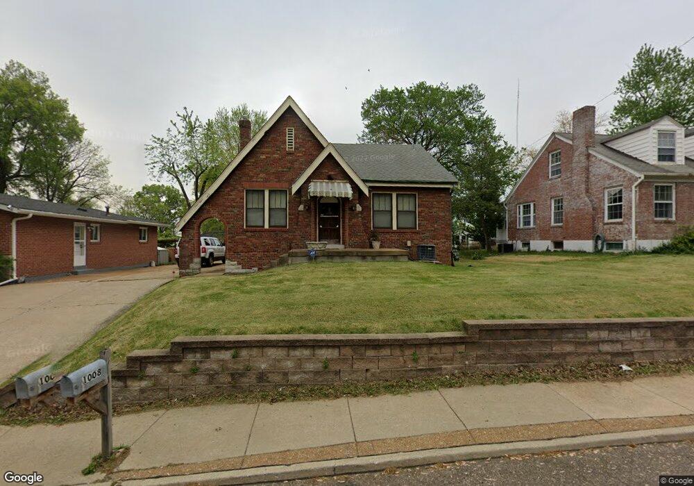
1008 S Laclede Station Rd S Saint Louis, MO 63119
Estimated Value: $188,000 - $290,000
2
Beds
1
Bath
1,067
Sq Ft
$227/Sq Ft
Est. Value
About This Home
This home is located at 1008 S Laclede Station Rd S, Saint Louis, MO 63119 and is currently estimated at $241,724, approximately $226 per square foot. 1008 S Laclede Station Rd S is a home located in St. Louis County with nearby schools including Mesnier Primary School, Gotsch Intermediate School, and Rogers Middle School.
Ownership History
Date
Name
Owned For
Owner Type
Purchase Details
Closed on
Jul 24, 2019
Sold by
Property Dynamics Llc
Bought by
1008 S Laclede Llc
Current Estimated Value
Purchase Details
Closed on
Nov 26, 2012
Sold by
New Melle Properties Llc
Bought by
Property Dynamics Llc
Purchase Details
Closed on
Dec 14, 2007
Sold by
Hollander Ruth
Bought by
New Melle Properties Llc
Create a Home Valuation Report for This Property
The Home Valuation Report is an in-depth analysis detailing your home's value as well as a comparison with similar homes in the area
Home Values in the Area
Average Home Value in this Area
Purchase History
| Date | Buyer | Sale Price | Title Company |
|---|---|---|---|
| 1008 S Laclede Llc | $90,000 | Us Title Main | |
| Property Dynamics Llc | -- | None Available | |
| New Melle Properties Llc | -- | None Available |
Source: Public Records
Tax History Compared to Growth
Tax History
| Year | Tax Paid | Tax Assessment Tax Assessment Total Assessment is a certain percentage of the fair market value that is determined by local assessors to be the total taxable value of land and additions on the property. | Land | Improvement |
|---|---|---|---|---|
| 2025 | $2,189 | $34,140 | $13,320 | $20,820 |
| 2024 | $2,189 | $26,600 | $8,870 | $17,730 |
| 2023 | $2,117 | $26,600 | $8,870 | $17,730 |
| 2022 | $2,416 | $27,710 | $9,770 | $17,940 |
| 2021 | $2,361 | $27,710 | $9,770 | $17,940 |
| 2020 | $2,085 | $22,800 | $8,720 | $14,080 |
| 2019 | $2,067 | $22,800 | $8,720 | $14,080 |
| 2018 | $1,986 | $19,360 | $6,080 | $13,280 |
| 2017 | $1,974 | $19,360 | $6,080 | $13,280 |
| 2016 | $1,324 | $13,690 | $5,230 | $8,460 |
| 2015 | $1,327 | $13,690 | $5,230 | $8,460 |
| 2014 | $1,333 | $13,680 | $5,170 | $8,510 |
Source: Public Records
Map
Nearby Homes
- 739 Hurstgreen Rd
- 1118 S Laclede Station Rd
- 7936 Radnor Dr
- 907 Edgar Rd
- 1405 Culverhill Dr
- 726 Landscape Ave
- 435 S Old Orchard Ave
- 725 Brookridge Dr
- 7101 Fernbrook Dr
- 5477 Kenrick Parke Dr Unit 1
- 737 Landscape Ave
- 6804 Snowy Owl Ln
- 431 Landscape Ct
- 423 S Old Orchard Ave
- 430 Cannonbury Dr
- 6738 Snowy Owl Ln
- 6 Girard Dr
- 7452 Rockwood Dr
- 6843 Preservation Pkwy
- 7243 General Sherman Ln
- 1006 S Laclede Station Rd S
- 1012 S Laclede Station Rd S
- 1109 Pembroke Dr
- 1113 Pembroke Dr
- 1002 S Laclede Station Rd S
- 1121 Pembroke Dr
- 1105 Pembroke Dr
- 1127 Pembroke Dr
- 751 Hurstgreen Rd
- 1101 Pembroke Dr
- 1137 Pembroke Dr
- 745 Hurstgreen Rd
- 7880 Chatwell Dr
- 7880 Chatwell Dr
- 1108 Pembroke Dr
- 1110 Pembroke Dr
- 1141 Pembroke Dr
- 1126 Pembroke Dr
- 1106 Pembroke Dr
- 1130 Pembroke Dr