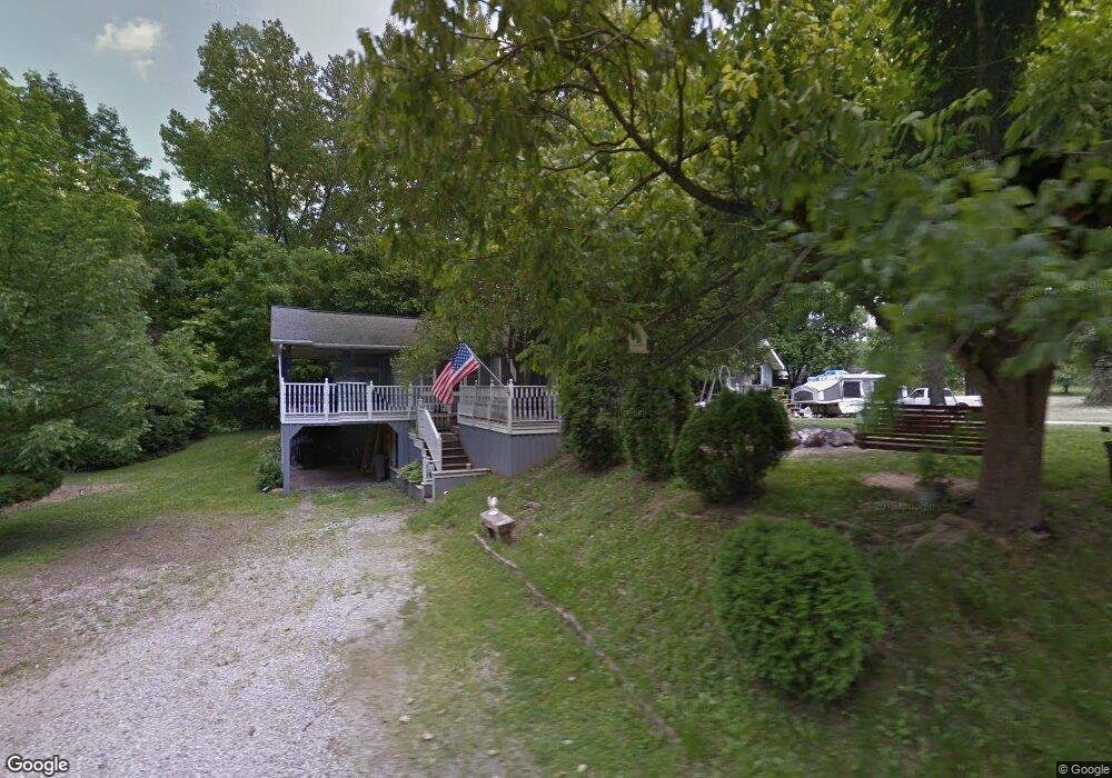
10080 Cattail Rd NE Pleasantville, OH 43148
Estimated Value: $284,000 - $384,000
3
Beds
2
Baths
1,419
Sq Ft
$237/Sq Ft
Est. Value
About This Home
This home is located at 10080 Cattail Rd NE, Pleasantville, OH 43148 and is currently estimated at $336,720, approximately $237 per square foot. 10080 Cattail Rd NE is a home located in Fairfield County with nearby schools including Millersport Elementary School and Millersport Jr/Sr High School.
Ownership History
Date
Name
Owned For
Owner Type
Purchase Details
Closed on
Dec 6, 1999
Sold by
Roley Dorothea
Bought by
Carr Polly D and Carr Michael P
Current Estimated Value
Home Financials for this Owner
Home Financials are based on the most recent Mortgage that was taken out on this home.
Original Mortgage
$103,500
Outstanding Balance
$32,669
Interest Rate
7.97%
Mortgage Type
New Conventional
Estimated Equity
$304,051
Create a Home Valuation Report for This Property
The Home Valuation Report is an in-depth analysis detailing your home's value as well as a comparison with similar homes in the area
Home Values in the Area
Average Home Value in this Area
Purchase History
| Date | Buyer | Sale Price | Title Company |
|---|---|---|---|
| Carr Polly D | $115,000 | -- |
Source: Public Records
Mortgage History
| Date | Status | Borrower | Loan Amount |
|---|---|---|---|
| Open | Carr Polly D | $103,500 |
Source: Public Records
Tax History Compared to Growth
Tax History
| Year | Tax Paid | Tax Assessment Tax Assessment Total Assessment is a certain percentage of the fair market value that is determined by local assessors to be the total taxable value of land and additions on the property. | Land | Improvement |
|---|---|---|---|---|
| 2024 | $4,300 | $71,540 | $14,630 | $56,910 |
| 2023 | $2,866 | $70,990 | $14,630 | $56,360 |
| 2022 | $2,881 | $70,990 | $14,630 | $56,360 |
| 2021 | $2,360 | $52,350 | $13,300 | $39,050 |
| 2020 | $2,368 | $52,350 | $13,300 | $39,050 |
| 2019 | $2,369 | $52,350 | $13,300 | $39,050 |
| 2018 | $2,048 | $38,370 | $12,250 | $26,120 |
| 2017 | $2,049 | $40,960 | $12,250 | $28,710 |
| 2016 | $1,890 | $40,960 | $12,250 | $28,710 |
| 2015 | $1,807 | $38,510 | $12,250 | $26,260 |
| 2014 | $1,466 | $38,510 | $12,250 | $26,260 |
| 2013 | $1,466 | $38,510 | $12,250 | $26,260 |
Source: Public Records
Map
Nearby Homes
- 0 Lake Rd NE
- 10159 Lake Rd NE
- 5831 Canal Rd NE
- 10121 Ohio 188
- 11655 New Salem Rd NE
- 11095 High Point Rd
- 3520 Baltimore Somerset Rd NE
- 3427 S Bank Rd NE
- 3333 S Bank Rd NE
- 3317 S Bank Rd NE
- 11248 Shell Beach Rd NE
- 3621 S Bank Rd NE
- 11355 Ohio 204
- 12126 State Route 188
- 12317 State Route 188
- 11253 Millersport Rd
- 12055 7th Ave
- 5170 Fairfield Beach Rd NE
- 13061 Dogwood Rd NE
- 10472 Township Road 80
- 10065 Cattail Rd NE
- 10060 Cattail Rd NE
- 10003 Cattail Rd NE
- 10177 Cattail Rd NE
- 9965 Cattail Rd NE
- 9835 Cattail Rd NE
- 5025 Geiger Rd NE
- 9705 Cattail Rd NE
- 5173 Geiger Rd NE
- 0 Cattail Rd NE Unit 9911716
- 0 Cattail Rd NE Unit 9911714
- 00 Cattail Rd
- 0 Cattail Rd NE Unit 9914993
- 0 Cattail Rd NE Unit 9917469
- 0 Cattail Rd NE Unit 9917464
- 0 Cattail Rd NE Unit 2441603
- 0 Cattail Rd NE Unit 210032226
- 0 Cattail Rd NE Unit 210032242
- 0 Cattail Rd NE Unit 212030020
- 0 Cattail Rd NE Unit 212030031