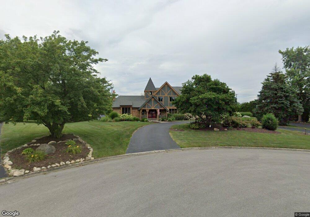
1009 Joey Ct New Lenox, IL 60451
Estimated Value: $645,001 - $678,000
--
Bed
--
Bath
--
Sq Ft
1.53
Acres
About This Home
This home is located at 1009 Joey Ct, New Lenox, IL 60451 and is currently estimated at $667,000. 1009 Joey Ct is a home located in Will County with nearby schools including Spencer Trail, Spencer Pointe, and Spencer Crossing Intermediate School.
Ownership History
Date
Name
Owned For
Owner Type
Purchase Details
Closed on
Jun 22, 2001
Sold by
Myers Thomas C and Myers Michelle M
Bought by
Sargent John and Sargent Michelle M
Current Estimated Value
Home Financials for this Owner
Home Financials are based on the most recent Mortgage that was taken out on this home.
Original Mortgage
$254,400
Outstanding Balance
$96,694
Interest Rate
7.11%
Estimated Equity
$570,306
Purchase Details
Closed on
Apr 8, 1994
Sold by
Langland James V and Langland Ruth E
Bought by
Myers Thomas C and Myers Michelle M
Home Financials for this Owner
Home Financials are based on the most recent Mortgage that was taken out on this home.
Original Mortgage
$243,200
Interest Rate
5.62%
Create a Home Valuation Report for This Property
The Home Valuation Report is an in-depth analysis detailing your home's value as well as a comparison with similar homes in the area
Home Values in the Area
Average Home Value in this Area
Purchase History
| Date | Buyer | Sale Price | Title Company |
|---|---|---|---|
| Sargent John | $318,000 | Chicago Title Insurance Co | |
| Myers Thomas C | $283,000 | -- |
Source: Public Records
Mortgage History
| Date | Status | Borrower | Loan Amount |
|---|---|---|---|
| Open | Sargent John | $254,400 | |
| Previous Owner | Myers Thomas C | $243,200 |
Source: Public Records
Tax History Compared to Growth
Tax History
| Year | Tax Paid | Tax Assessment Tax Assessment Total Assessment is a certain percentage of the fair market value that is determined by local assessors to be the total taxable value of land and additions on the property. | Land | Improvement |
|---|---|---|---|---|
| 2024 | $14,838 | $196,474 | $36,839 | $159,635 |
| 2023 | $14,838 | $179,102 | $33,582 | $145,520 |
| 2022 | $14,303 | $164,995 | $30,937 | $134,058 |
| 2021 | $12,718 | $155,172 | $29,095 | $126,077 |
| 2020 | $12,364 | $149,636 | $28,057 | $121,579 |
| 2019 | $11,835 | $144,996 | $27,187 | $117,809 |
| 2018 | $11,565 | $139,998 | $26,250 | $113,748 |
| 2017 | $10,983 | $135,973 | $25,495 | $110,478 |
| 2016 | $10,671 | $132,334 | $24,813 | $107,521 |
| 2015 | $10,340 | $128,169 | $24,032 | $104,137 |
| 2014 | $10,340 | $126,586 | $23,735 | $102,851 |
| 2013 | $10,340 | $128,292 | $24,055 | $104,237 |
Source: Public Records
Map
Nearby Homes
- 12118 Sarkis Dr
- 2609 Walter Dr
- 12415 Foxborough Dr
- 12417 Lajunta Ct
- 19411 Baron Rd
- 19909 Foxborough Dr
- 19418 Boulder Ridge Dr
- 501 Bryan Trail
- 11966 Duchess Ave
- 12526 Surrey Ct
- 19502 115th Ave Unit A
- 11525 Edgewood Dr
- 12752 Berkshire Dr
- 11420 Kluth Dr
- 11323 1st St
- 11325 1st St
- 19429 114th Ave
- Willowcrest Lot 2 Willowcrest
- 1920 Tessington Ct
- 1931 Tessington Ct
- 1005 Joey Ct
- 1004 Joey Ct
- 1001 Joey Ct
- 1000 Joey Ct
- 1008 Donald Ct
- 1004 Donald Ct
- 1012 Donald Ct
- 12047 Sarkis Dr
- 12061 Sarkis Dr
- 12033 Sarkis Dr
- 1000 Donald Ct
- 12075 Sarkis Dr
- 12019 Sarkis Dr
- 12005 Sarkis Dr
- 1100 Donald Ct
- 19924 S Townline Rd
- 12089 Sarkis Dr
- 12103 Sarkis Dr
- 1104 Donald Ct
- 12070 Sarkis Dr