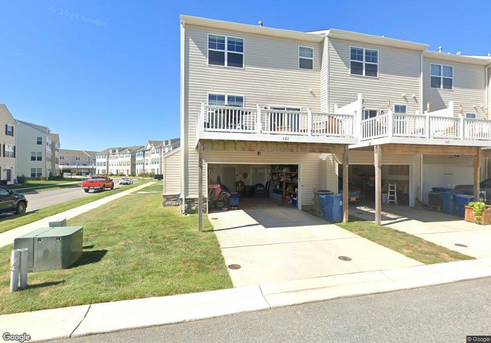
101 Anthony Ln Unit E-21 Stevensville, MD 21666
Estimated Value: $484,156 - $536,000
3
Beds
4
Baths
2,300
Sq Ft
$218/Sq Ft
Est. Value
About This Home
This home is located at 101 Anthony Ln Unit E-21, Stevensville, MD 21666 and is currently estimated at $502,539, approximately $218 per square foot. 101 Anthony Ln Unit E-21 is a home located in Queen Anne's County with nearby schools including Kent Island Elementary School, Bayside Elementary School, and Matapeake Middle School.
Ownership History
Date
Name
Owned For
Owner Type
Purchase Details
Closed on
Apr 21, 2016
Sold by
Ellendale Townhomes By Lacrosse Llc
Bought by
Rott Carrie and Marshall Rickert W
Current Estimated Value
Home Financials for this Owner
Home Financials are based on the most recent Mortgage that was taken out on this home.
Original Mortgage
$250,000
Outstanding Balance
$198,805
Interest Rate
3.71%
Mortgage Type
New Conventional
Estimated Equity
$303,734
Create a Home Valuation Report for This Property
The Home Valuation Report is an in-depth analysis detailing your home's value as well as a comparison with similar homes in the area
Home Values in the Area
Average Home Value in this Area
Purchase History
| Date | Buyer | Sale Price | Title Company |
|---|---|---|---|
| Rott Carrie | $370,000 | Attorney |
Source: Public Records
Mortgage History
| Date | Status | Borrower | Loan Amount |
|---|---|---|---|
| Open | Rott Carrie | $250,000 | |
| Closed | Rott Carrie | $250,000 |
Source: Public Records
Tax History Compared to Growth
Tax History
| Year | Tax Paid | Tax Assessment Tax Assessment Total Assessment is a certain percentage of the fair market value that is determined by local assessors to be the total taxable value of land and additions on the property. | Land | Improvement |
|---|---|---|---|---|
| 2025 | $3,693 | $408,733 | $0 | $0 |
| 2024 | $3,509 | $381,167 | $0 | $0 |
| 2023 | $3,331 | $353,600 | $125,000 | $228,600 |
| 2022 | $3,331 | $353,600 | $125,000 | $228,600 |
| 2021 | $3,505 | $353,600 | $125,000 | $228,600 |
| 2020 | $3,505 | $365,400 | $125,000 | $240,400 |
| 2019 | $3,501 | $365,067 | $0 | $0 |
| 2018 | $3,498 | $364,733 | $0 | $0 |
| 2017 | $3,495 | $364,400 | $0 | $0 |
| 2016 | -- | $364,400 | $0 | $0 |
Source: Public Records
Map
Nearby Homes
- 241 Jessica Lyn Ave
- 111 Keenan Way
- 119 Keenan Way
- 858 Moorings Cir Unit 11
- 298 Moorings Cir
- 736 Moorings Cir Unit 35
- 349 Topside Dr
- 312 Topside Dr Unit 223
- 122 E Main St
- 1 UNIT 2 Compass Cir
- 103 Irene Way
- 0 Sunset Wharf Lot D-1 Unit MDQA2010276
- 306 Irene Way
- 0 Sunset Wharf Lot D-3 Unit MDQA2010280
- 526 Victoria Dr
- 515 Love Point Rd
- 102 Bobbitt Ct
- 619 Love Point Rd
- 802 Broadcreek Dr
- 312 William Way
- 101 Anthony Ln
- 105 Anthony Ln Unit E-20
- 105 Anthony Ln
- 109 Anthony Ln Unit E-19
- 109 Anthony Ln
- 115 Anthony Ln Unit E-18
- 115 Anthony Ln
- 119 Anthony Ln Unit E-17
- 119 Anthony Ln
- 112 Sophie Ln
- 102 Sophie Ln
- 106 Anthony Ln Unit E-23
- 106 Anthony Ln
- 102 Anthony Ln Unit E-22
- 102 Anthony Ln
- 106 Sophie Ln
- 201 Mikes Way Unit D-20
- 201 Mikes Way
- 110 Anthony Ln Unit E-24
- 110 Anthony Ln