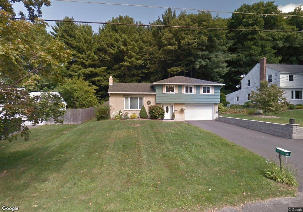
101 Asci Dr Pittsfield, MA 01201
Estimated Value: $375,000 - $452,000
3
Beds
3
Baths
1,800
Sq Ft
$223/Sq Ft
Est. Value
About This Home
This home is located at 101 Asci Dr, Pittsfield, MA 01201 and is currently estimated at $401,301, approximately $222 per square foot. 101 Asci Dr is a home located in Berkshire County with nearby schools including Allendale Elementary School, John T. Reid Middle School, and Pittsfield High School.
Ownership History
Date
Name
Owned For
Owner Type
Purchase Details
Closed on
Nov 10, 2011
Sold by
Anderson Jerome J and Anderson Karen M
Bought by
Conant Kelly L
Current Estimated Value
Purchase Details
Closed on
Aug 1, 2001
Sold by
Asci Patricia A
Bought by
Anderson Jerome J and Anderson Karen M
Purchase Details
Closed on
Jul 1, 1996
Sold by
Murdock Kevin P and Murdock Doreen A
Bought by
Belanger Patricia A
Purchase Details
Closed on
Nov 17, 1994
Sold by
Goldenberg Philip H and Goldenberg Susan E
Bought by
Murdock Kevin P and Murdock Doreen
Create a Home Valuation Report for This Property
The Home Valuation Report is an in-depth analysis detailing your home's value as well as a comparison with similar homes in the area
Home Values in the Area
Average Home Value in this Area
Purchase History
| Date | Buyer | Sale Price | Title Company |
|---|---|---|---|
| Conant Kelly L | $230,000 | -- | |
| Conant Kelly L | $230,000 | -- | |
| Conant Kelly L | $230,000 | -- | |
| Anderson Jerome J | $180,000 | -- | |
| Anderson Jerome J | $180,000 | -- | |
| Belanger Patricia A | $148,000 | -- | |
| Belanger Patricia A | $148,000 | -- | |
| Murdock Kevin P | $131,000 | -- | |
| Murdock Kevin P | $131,000 | -- |
Source: Public Records
Mortgage History
| Date | Status | Borrower | Loan Amount |
|---|---|---|---|
| Previous Owner | Murdock Kevin P | $654,000 | |
| Previous Owner | Murdock Kevin P | $404,000 |
Source: Public Records
Tax History Compared to Growth
Tax History
| Year | Tax Paid | Tax Assessment Tax Assessment Total Assessment is a certain percentage of the fair market value that is determined by local assessors to be the total taxable value of land and additions on the property. | Land | Improvement |
|---|---|---|---|---|
| 2025 | $6,634 | $369,800 | $70,600 | $299,200 |
| 2024 | $6,029 | $326,800 | $70,600 | $256,200 |
| 2023 | $5,633 | $307,500 | $70,600 | $236,900 |
| 2022 | $5,121 | $275,900 | $70,600 | $205,300 |
| 2021 | $4,732 | $245,800 | $70,600 | $175,200 |
| 2020 | $4,535 | $230,100 | $60,600 | $169,500 |
| 2019 | $4,329 | $222,900 | $58,600 | $164,300 |
| 2018 | $4,484 | $224,100 | $58,600 | $165,500 |
| 2017 | $4,228 | $215,400 | $55,600 | $159,800 |
| 2016 | $4,000 | $213,200 | $55,600 | $157,600 |
| 2015 | $3,850 | $213,200 | $55,600 | $157,600 |
Source: Public Records
Map
Nearby Homes
- 17 Kittredge Rd
- 144 Kittredge Rd
- 82 Williamsburg Terrace
- 0 Cheshire Rd
- 72 Meadowview Dr
- 45 Patricia Ave
- 98 Oak Hill Rd
- 127 Oak Hill Rd
- 215 Partridge Rd
- 67 Gulf Rd
- 0 Crane Ave
- 9 Crane Ave
- 330 Connecticut Ave
- 196 Park Ave
- 41 Oak St
- 25 Kensington Ave
- 38 Allengate Ave
- 29 John St
- 326 Dalton Ave
- 321 High St