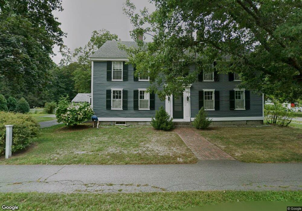
101 Boston Post Rd Amherst, NH 03031
Estimated Value: $770,000 - $986,000
4
Beds
3
Baths
3,484
Sq Ft
$257/Sq Ft
Est. Value
About This Home
This home is located at 101 Boston Post Rd, Amherst, NH 03031 and is currently estimated at $894,862, approximately $256 per square foot. 101 Boston Post Rd is a home with nearby schools including Wilkins Elementary School, Amherst Middle School, and Souhegan Cooperative High School.
Ownership History
Date
Name
Owned For
Owner Type
Purchase Details
Closed on
Mar 15, 1996
Sold by
Bolnick Ralph and Bolnick Lois A
Bought by
Ahearn John S and Ahearn Susan G
Current Estimated Value
Home Financials for this Owner
Home Financials are based on the most recent Mortgage that was taken out on this home.
Original Mortgage
$135,000
Interest Rate
6.97%
Create a Home Valuation Report for This Property
The Home Valuation Report is an in-depth analysis detailing your home's value as well as a comparison with similar homes in the area
Home Values in the Area
Average Home Value in this Area
Purchase History
We collect this data history from publicly available records. To have your information removed, we recommend requesting removal directly through your county’s website.
| Date | Buyer | Sale Price | Title Company |
|---|---|---|---|
| Ahearn John S | $225,000 | -- |
Source: Public Records
Mortgage History
We collect this data history from publicly available records. To have your information removed, we recommend requesting removal directly through your county’s website.
| Date | Status | Borrower | Loan Amount |
|---|---|---|---|
| Open | Ahearn John S | $350,000 | |
| Closed | Ahearn John S | $135,000 |
Source: Public Records
Tax History
| Year | Tax Paid | Tax Assessment Tax Assessment Total Assessment is a certain percentage of the fair market value that is determined by local assessors to be the total taxable value of land and additions on the property. | Land | Improvement |
|---|---|---|---|---|
| 2025 | $15,587 | $650,000 | $193,900 | $456,100 |
| 2024 | $14,905 | $650,000 | $193,900 | $456,100 |
| 2023 | $14,222 | $650,000 | $193,900 | $456,100 |
| 2022 | $13,735 | $650,000 | $193,900 | $456,100 |
| 2021 | $13,852 | $650,000 | $193,900 | $456,100 |
| 2020 | $13,531 | $475,100 | $150,400 | $324,700 |
| 2019 | $12,809 | $475,100 | $150,400 | $324,700 |
| 2018 | $233 | $475,100 | $150,400 | $324,700 |
| 2017 | $12,357 | $475,100 | $150,400 | $324,700 |
| 2016 | $11,925 | $475,100 | $150,400 | $324,700 |
| 2015 | $12,146 | $458,700 | $172,600 | $286,100 |
| 2014 | $12,229 | $458,700 | $172,600 | $286,100 |
| 2013 | $12,133 | $458,700 | $172,600 | $286,100 |
Source: Public Records
Map
Nearby Homes
- 117 Boston Post Rd
- 2 MacK Hill Rd
- 166 Amherst St
- 19 Old Milford Rd
- 19 Baboosic Lake Rd
- 3 Debbie Ln
- 2A Renee Dr
- 19 Mulberry Ln
- 3 Renee Dr
- 1 Renee Dr
- 7 Village Woods Dr
- 5 N Meadow Rd
- 28 Spring Rd
- 5 Old Manchester Rd
- 7 Corduroy Rd Unit 10
- 7 Corduroy Rd Unit 24
- 12 Candlewood Dr
- 9 Tarleton Ln
- 1 Tarleton Ln
- 15 Martingale Rd
Your Personal Tour Guide
Ask me questions while you tour the home.