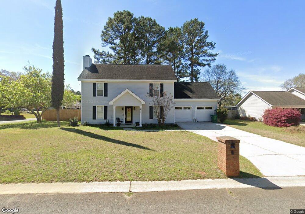
101 Brian Dr Warner Robins, GA 31088
Estimated Value: $231,914 - $254,000
3
Beds
2
Baths
1,628
Sq Ft
$148/Sq Ft
Est. Value
About This Home
This home is located at 101 Brian Dr, Warner Robins, GA 31088 and is currently estimated at $240,229, approximately $147 per square foot. 101 Brian Dr is a home located in Houston County with nearby schools including Quail Run Elementary School, Thomson Middle School, and Northside High School.
Ownership History
Date
Name
Owned For
Owner Type
Purchase Details
Closed on
Sep 30, 1996
Sold by
Thames Rev L E
Bought by
Bledsoe Lesley A
Current Estimated Value
Purchase Details
Closed on
Aug 23, 1996
Sold by
Marr Mahlon L and Marr Elaine B
Bought by
Thames Rev L E
Purchase Details
Closed on
May 1, 1992
Sold by
Dent Sammy E
Bought by
Marr Mahlon L and Marr Elaine B
Purchase Details
Closed on
Jul 5, 1989
Sold by
Herndon Thomas
Bought by
Dent Sammy E
Purchase Details
Closed on
Jan 12, 1989
Sold by
Bowen Bowen L and Bowen Rubinell C
Bought by
Herndon Thomas
Create a Home Valuation Report for This Property
The Home Valuation Report is an in-depth analysis detailing your home's value as well as a comparison with similar homes in the area
Home Values in the Area
Average Home Value in this Area
Purchase History
| Date | Buyer | Sale Price | Title Company |
|---|---|---|---|
| Bledsoe Lesley A | $102,500 | -- | |
| Thames Rev L E | $100,000 | -- | |
| Marr Mahlon L | $84,500 | -- | |
| Dent Sammy E | -- | -- | |
| Herndon Thomas | -- | -- |
Source: Public Records
Tax History Compared to Growth
Tax History
| Year | Tax Paid | Tax Assessment Tax Assessment Total Assessment is a certain percentage of the fair market value that is determined by local assessors to be the total taxable value of land and additions on the property. | Land | Improvement |
|---|---|---|---|---|
| 2024 | $1,604 | $67,040 | $8,000 | $59,040 |
| 2023 | $1,468 | $60,720 | $6,800 | $53,920 |
| 2022 | $1,404 | $58,080 | $6,800 | $51,280 |
| 2021 | $1,301 | $53,560 | $6,800 | $46,760 |
| 2020 | $1,162 | $47,600 | $6,800 | $40,800 |
| 2019 | $1,162 | $47,600 | $6,800 | $40,800 |
| 2018 | $1,162 | $47,600 | $6,800 | $40,800 |
| 2017 | $1,163 | $47,600 | $6,800 | $40,800 |
| 2016 | $1,165 | $47,600 | $6,800 | $40,800 |
| 2015 | $1,167 | $47,600 | $6,800 | $40,800 |
| 2014 | -- | $47,600 | $6,800 | $40,800 |
| 2013 | -- | $47,600 | $6,800 | $40,800 |
Source: Public Records
Map
Nearby Homes
- Maple Plan at
- Belmont Plan at
- Oakwood Plan at
- Cannaberra Plan at
- Jackson Plan at
- Hawthorn Plan at
- Camden Plan at
- Delilah Plan at
- Aspen Plan at
- Dogwood Plan at
- Cypress Plan at
- Harrison Plan at
- 205 Bowen Dr
- 307 Pheasant Ridge Dr
- 108 Covey Run Dr
- 322 Pheasant Ridge Dr
- 208 Antler Trail
- 203 Morning Dove Ln
- 314 Briarmoor Dr
- 801 Osigian Blvd
- 103 Brian Dr
- 202 Bowen Dr
- 201 Bowen Dr
- 203 Bowen Dr
- 118 Bowen Dr
- 105 Brian Dr
- 204 Bowen Dr
- 204 Bowen Dr
- 121 Bowen Dr
- 1010 S Houston Lake Rd Unit 38728198
- 1010 S Houston Lake Rd
- 1010 S Houston Lake Rd
- 102 Brian Dr
- 107 Angel Ct
- 107 Angel Ct
- 105 Angel Ct
- 105 Angel Ct
- 104 Brian Dr
- 119 Bowen Dr
- 107 Brian Dr