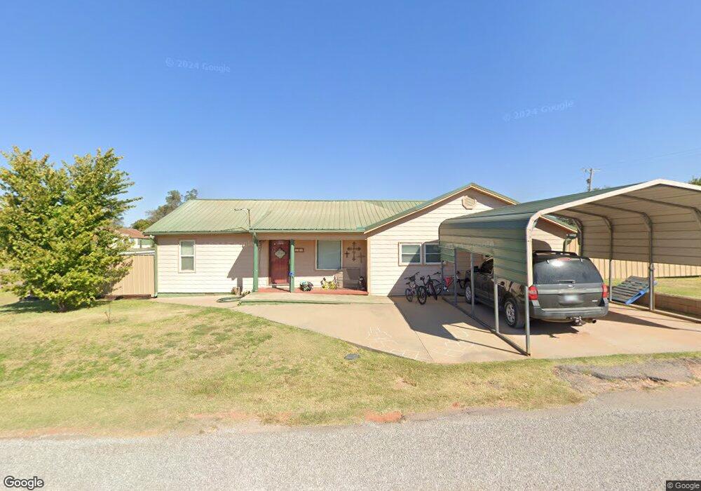
101 E Second St Leedey, OK 73654
Estimated Value: $104,000 - $190,000
2
Beds
1
Bath
1,580
Sq Ft
$84/Sq Ft
Est. Value
About This Home
This home is located at 101 E Second St, Leedey, OK 73654 and is currently estimated at $132,795, approximately $84 per square foot. 101 E Second St is a home with nearby schools including Leedey Elementary School and Leedey High School.
Ownership History
Date
Name
Owned For
Owner Type
Purchase Details
Closed on
Nov 7, 2014
Sold by
Leedey Church Of Christ
Bought by
Boren Travis B and Boren Jennife
Current Estimated Value
Purchase Details
Closed on
May 14, 2013
Sold by
Nixon Raymond and Nixon Gertrude
Bought by
Boren Travis B and Boren Jennife
Purchase Details
Closed on
Aug 13, 2008
Sold by
Great Plains National Ban
Bought by
Nixon Raymond E and Nixon Gertr
Purchase Details
Closed on
May 1, 2008
Sold by
Debruin John and Debruin Jami
Bought by
Great Plains Nat'L Bank
Purchase Details
Closed on
Oct 19, 1999
Sold by
Kauk
Bought by
Debruin
Purchase Details
Closed on
May 3, 1996
Sold by
Andrews
Bought by
Kauk
Purchase Details
Closed on
Nov 23, 1993
Sold by
Jones
Bought by
Andrews
Create a Home Valuation Report for This Property
The Home Valuation Report is an in-depth analysis detailing your home's value as well as a comparison with similar homes in the area
Purchase History
| Date | Buyer | Sale Price | Title Company |
|---|---|---|---|
| Boren Travis B | $500 | -- | |
| Boren Travis B | $94,000 | -- | |
| Nixon Raymond E | $10,000 | -- | |
| Great Plains Nat'L Bank | $32,000 | -- | |
| Debruin | $15,000 | -- | |
| Kauk | $10,500 | -- | |
| Andrews | $7,000 | -- |
Source: Public Records
Tax History
| Year | Tax Paid | Tax Assessment Tax Assessment Total Assessment is a certain percentage of the fair market value that is determined by local assessors to be the total taxable value of land and additions on the property. | Land | Improvement |
|---|---|---|---|---|
| 2025 | $298 | $5,231 | $780 | $4,451 |
| 2024 | $3 | $5,078 | $757 | $4,321 |
| 2023 | $295 | $5,078 | $758 | $4,320 |
| 2022 | $290 | $4,786 | $748 | $4,038 |
| 2021 | $283 | $4,647 | $748 | $3,899 |
| 2020 | $258 | $4,512 | $748 | $3,764 |
| 2019 | $273 | $4,790 | $748 | $4,042 |
| 2018 | $291 | $5,023 | $449 | $4,574 |
| 2017 | $301 | $5,117 | $449 | $4,668 |
| 2016 | $334 | $5,574 | $449 | $5,125 |
| 2015 | $363 | $5,997 | $234 | $5,763 |
| 2014 | $632 | $10,339 | $206 | $10,133 |
Source: Public Records
Map
Nearby Homes
- 101 N Main St
- 0 E 1st St
- 305 E Seventh St
- 406 E 10th St
- 514 E 10th St
- 1601 S Hobson Ave
- 19112 Oklahoma 47
- 207711 E 780 Rd
- 77878 N 2080 Rd
- 000 N 2080 Rd 800 Acres
- N 2080 Rd
- 208297 Donley St
- 0000 N County Rd 2110
- 0 E 910 Rd
- 9448 N 2020 Rd
- 0000 N 2210 Rd
- 302 N 8th St
- 000 S County Rd 195
- 1005 Conley St
- 000 E 980 Rd
- 201 S Main St
- 131 S Main St
- 134 S Phillips Ave
- 119 N Main Ave
- 140 S Phillips Ave
- 130 S Phillips Ave
- 124 S Phillips Ave
- 108 S Main St
- 202 S Phillips Ave
- 114 S Phillips Ave
- 117 W Second St
- 107 E 3rd St
- 101 E 3rd St
- 115 E Third St
- 112 S Main St
- 109 N Main St
- 123 E Third St
- 117 S Hobson Ave
- 101 S Main St
- 139 S Phillips Ave