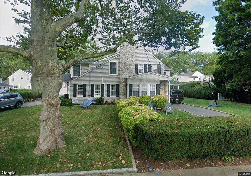
101 Elton Rd Garden City, NY 11530
Estimated Value: $864,000 - $878,775
4
Beds
2
Baths
2,060
Sq Ft
$423/Sq Ft
Est. Value
About This Home
This home is located at 101 Elton Rd, Garden City, NY 11530 and is currently estimated at $871,388, approximately $423 per square foot. 101 Elton Rd is a home located in Nassau County with nearby schools including St Anne's School.
Ownership History
Date
Name
Owned For
Owner Type
Purchase Details
Closed on
Apr 29, 2021
Sold by
Rudolph James W
Bought by
Mccarthy Michael and Mccarthy Erica
Current Estimated Value
Home Financials for this Owner
Home Financials are based on the most recent Mortgage that was taken out on this home.
Original Mortgage
$559,200
Outstanding Balance
$503,794
Interest Rate
3%
Mortgage Type
New Conventional
Estimated Equity
$367,594
Create a Home Valuation Report for This Property
The Home Valuation Report is an in-depth analysis detailing your home's value as well as a comparison with similar homes in the area
Home Values in the Area
Average Home Value in this Area
Purchase History
| Date | Buyer | Sale Price | Title Company |
|---|---|---|---|
| Mccarthy Michael | $699,000 | Titlevest Agency Llc | |
| Mccarthy Michael | $699,000 | Titlevest Agency Llc | |
| Mccarthy Michael | $699,000 | Titlevest Agency Llc |
Source: Public Records
Mortgage History
| Date | Status | Borrower | Loan Amount |
|---|---|---|---|
| Open | Mccarthy Michael | $559,200 | |
| Closed | Mccarthy Michael | $559,200 |
Source: Public Records
Tax History Compared to Growth
Tax History
| Year | Tax Paid | Tax Assessment Tax Assessment Total Assessment is a certain percentage of the fair market value that is determined by local assessors to be the total taxable value of land and additions on the property. | Land | Improvement |
|---|---|---|---|---|
| 2025 | $10,828 | $512 | $213 | $299 |
| 2024 | $2,164 | $568 | $236 | $332 |
| 2023 | $13,957 | $662 | $288 | $374 |
| 2022 | $13,957 | $625 | $260 | $365 |
| 2021 | $11,701 | $637 | $265 | $372 |
| 2020 | $8,242 | $801 | $800 | $1 |
| 2019 | $1,736 | $801 | $800 | $1 |
| 2018 | $6,616 | $801 | $0 | $0 |
| 2017 | $6,487 | $851 | $664 | $187 |
| 2016 | $8,169 | $901 | $703 | $198 |
| 2015 | $2,084 | $1,081 | $844 | $237 |
| 2014 | $2,084 | $1,081 | $844 | $237 |
| 2013 | $1,942 | $1,081 | $844 | $237 |
Source: Public Records
Map
Nearby Homes
- 67 Fernwood Terrace
- 71 Chester Ave
- 31 Chester Ave
- 112 Bromleigh Rd
- 143 Bromleigh Rd
- 217 Elton Rd
- 7 Yale St
- 501 Tulip Ave Unit A
- 15 Stewart Ave
- 261 Fernwood Terrace
- 911 Covert Ave
- 645 S 10th St
- 700 Tulip Ave
- 636 S 13th St
- 72 Harrison St
- 700 Covert Ave
- 908 6th Ave
- 1045 Cathedral Ave
- 1306 6th Ave
- 515 S 10th St