Estimated Value: $51,004 - $74,000
3
Beds
2
Baths
960
Sq Ft
$67/Sq Ft
Est. Value
About This Home
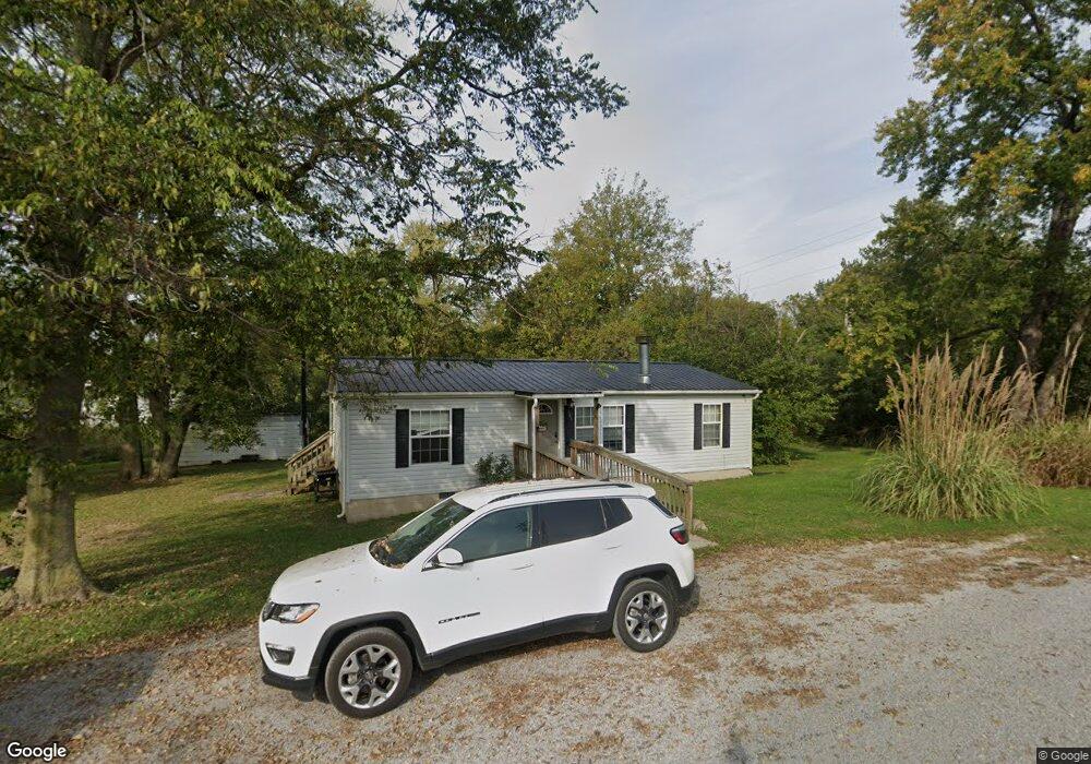
This home is located at 101 First St, Percy, IL 62272 and is currently estimated at $64,251, approximately $66 per square foot. 101 First St is a home located in Randolph County with nearby schools including Trico Elementary School and St. Mark's Lutheran School.
Ownership History
Date
Name
Owned For
Owner Type
Purchase Details
Closed on
Dec 8, 2020
Sold by
Hall David and Gendron Brandy J
Bought by
Hall Trust
Current Estimated Value
Purchase Details
Closed on
Jul 19, 2018
Sold by
Ashby Lila
Bought by
Hall David and Gendron Brandy J
Home Financials for this Owner
Home Financials are based on the most recent Mortgage that was taken out on this home.
Original Mortgage
$44,973
Interest Rate
4.5%
Mortgage Type
New Conventional
Purchase Details
Closed on
Nov 29, 2006
Sold by
Seymour James A and Seymour Carol Ann
Bought by
Ashby Jerry Lee
Create a Home Valuation Report for This Property
The Home Valuation Report is an in-depth analysis detailing your home's value as well as a comparison with similar homes in the area
Purchase History
| Date | Buyer | Sale Price | Title Company |
|---|---|---|---|
| Hall Trust | -- | None Available | |
| Hall David | $32,000 | None Available | |
| Ashby Jerry Lee | -- | None Available |
Source: Public Records
Mortgage History
| Date | Status | Borrower | Loan Amount |
|---|---|---|---|
| Previous Owner | Hall David | $44,973 |
Source: Public Records
Tax History
| Year | Tax Paid | Tax Assessment Tax Assessment Total Assessment is a certain percentage of the fair market value that is determined by local assessors to be the total taxable value of land and additions on the property. | Land | Improvement |
|---|---|---|---|---|
| 2024 | $684 | $9,180 | $2,960 | $6,220 |
| 2022 | $643 | $8,575 | $2,765 | $5,810 |
| 2021 | $550 | $7,385 | $1,695 | $5,690 |
| 2020 | $524 | $7,024 | $1,610 | $5,414 |
| 2019 | $541 | $6,285 | $1,440 | $4,845 |
| 2018 | $282 | $3,793 | $1,588 | $2,205 |
| 2017 | $109 | $1,425 | $1,425 | $0 |
| 2016 | $108 | $1,505 | $1,505 | $0 |
| 2015 | $107 | $1,430 | $1,430 | $0 |
| 2014 | $107 | $1,495 | $1,495 | $0 |
| 2013 | $109 | $1,440 | $1,440 | $0 |
Source: Public Records
Map
Nearby Homes
- 306 W Plum St
- 201 S Park Ct
- 310 E Almond St
- 405 S 3rd St
- 507 E Pine St
- 603 N Maple St
- 708 E Walnut St
- 607 E Hancock St
- 307 E Jenkins St
- 203 E Jenkins St
- 404 E Massachusetts St
- 803 N Sparta St
- 610 S Ridge Ave
- 701 S Ridge Ave
- 510 S Charles St
- 304 Crestview Dr
- 1117 Puxico Rd
- 402 W Hetherington St
- 807 Broadway St
- 402 W Pine St
Your Personal Tour Guide
Ask me questions while you tour the home.