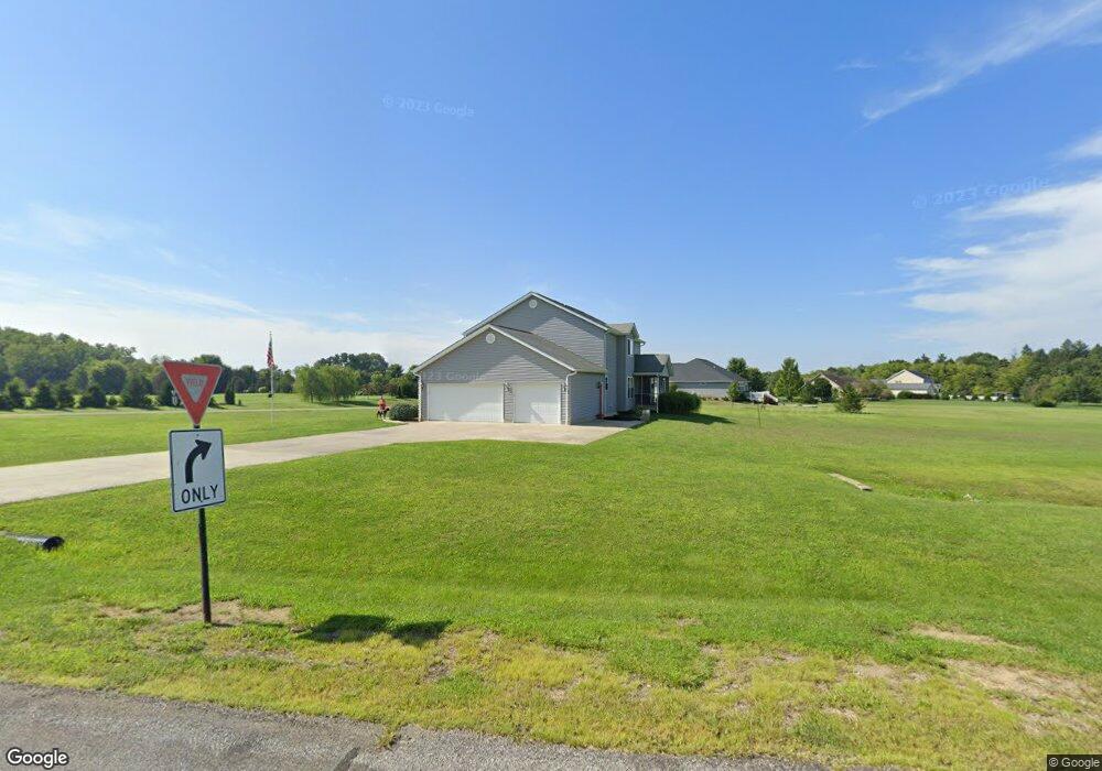
101 Foxridge Way Hebron, OH 43025
Union NeighborhoodEstimated Value: $626,000 - $709,000
4
Beds
3
Baths
3,086
Sq Ft
$214/Sq Ft
Est. Value
About This Home
This home is located at 101 Foxridge Way, Hebron, OH 43025 and is currently estimated at $659,787, approximately $213 per square foot. 101 Foxridge Way is a home located in Licking County with nearby schools including Jackson Intermediate School, Lakewood Middle School, and Lakewood High School.
Ownership History
Date
Name
Owned For
Owner Type
Purchase Details
Closed on
Jun 17, 2004
Sold by
Auld Ridge Development Llc
Bought by
Mcwilliams Robert W and Mcwilliams Paula S
Current Estimated Value
Create a Home Valuation Report for This Property
The Home Valuation Report is an in-depth analysis detailing your home's value as well as a comparison with similar homes in the area
Home Values in the Area
Average Home Value in this Area
Purchase History
| Date | Buyer | Sale Price | Title Company |
|---|---|---|---|
| Mcwilliams Robert W | $66,100 | -- |
Source: Public Records
Tax History Compared to Growth
Tax History
| Year | Tax Paid | Tax Assessment Tax Assessment Total Assessment is a certain percentage of the fair market value that is determined by local assessors to be the total taxable value of land and additions on the property. | Land | Improvement |
|---|---|---|---|---|
| 2024 | $6,778 | $168,950 | $38,990 | $129,960 |
| 2023 | $11,535 | $168,950 | $38,990 | $129,960 |
| 2022 | $5,240 | $122,750 | $34,620 | $88,130 |
| 2021 | $5,408 | $122,750 | $34,620 | $88,130 |
| 2020 | $5,603 | $122,750 | $34,620 | $88,130 |
| 2019 | $5,567 | $114,770 | $26,640 | $88,130 |
| 2018 | $5,546 | $0 | $0 | $0 |
| 2017 | $5,608 | $0 | $0 | $0 |
| 2016 | $4,544 | $0 | $0 | $0 |
| 2015 | $2,257 | $0 | $0 | $0 |
| 2014 | $2,255 | $0 | $0 | $0 |
| 2013 | $2,257 | $0 | $0 | $0 |
Source: Public Records
Map
Nearby Homes
- 6651 Lancaster Rd
- 332 Waters Edge
- 59 Squire Ln
- 0 Hayes Rd
- 3343 Hayes Rd
- 1906 Seminary Rd
- 1400 Hayes Rd
- 2241 Seminary Rd SE
- 1283 Union Station Rd
- 219 Sycamore Rd
- 7667 Gale Rd SW
- 0 Refugee Rd SE Unit 225031623
- 7740 Gale Rd SW
- 104 Cumberland Meadows Cir
- 814 W Main St
- 799 Old James Rd
- 106 Newark St
- 140 Hamilton Ave
- 5020 Deeds Rd SW
- 5038 Deeds Rd SW
- 112 Fox Ridge Way Unit Lt 13
- 116 Fox Ridge Way Unit Lt 14
- 0 Fox Ridge Way Unit Lt 12 2341025
- 0 Fox Ridge Way Unit Lt 14 2341028
- 0 Fox Ridge Way Unit Lt 11 2341024
- 0 Fox Ridge Way Unit Lt 13 2341026
- 0 Fox Ridge Way Unit Lt 10
- 118 Auld Ridge Way Unit Lt 16
- 118 Auld Ridge Way
- 126 Auld Ridge
- 100 Fox Ridge Way Unit Lt 10
- 101 Whitetail Ridge Way Unit Lt 3
- 101 Whitetail Ridge Way Unit Lot 3
- 101 Whitetail Ridge Way
- 104 Fox Ridge Way Unit Lt 11
- 104 Fox Ridge Way Unit Lot 9
- 104 Fox Ridge Way Unit Lot 11
- 104 Fox Ridge Way
- 110 Auld Ridge Way
- 110 Auld Ridge Way Unit Lt 17