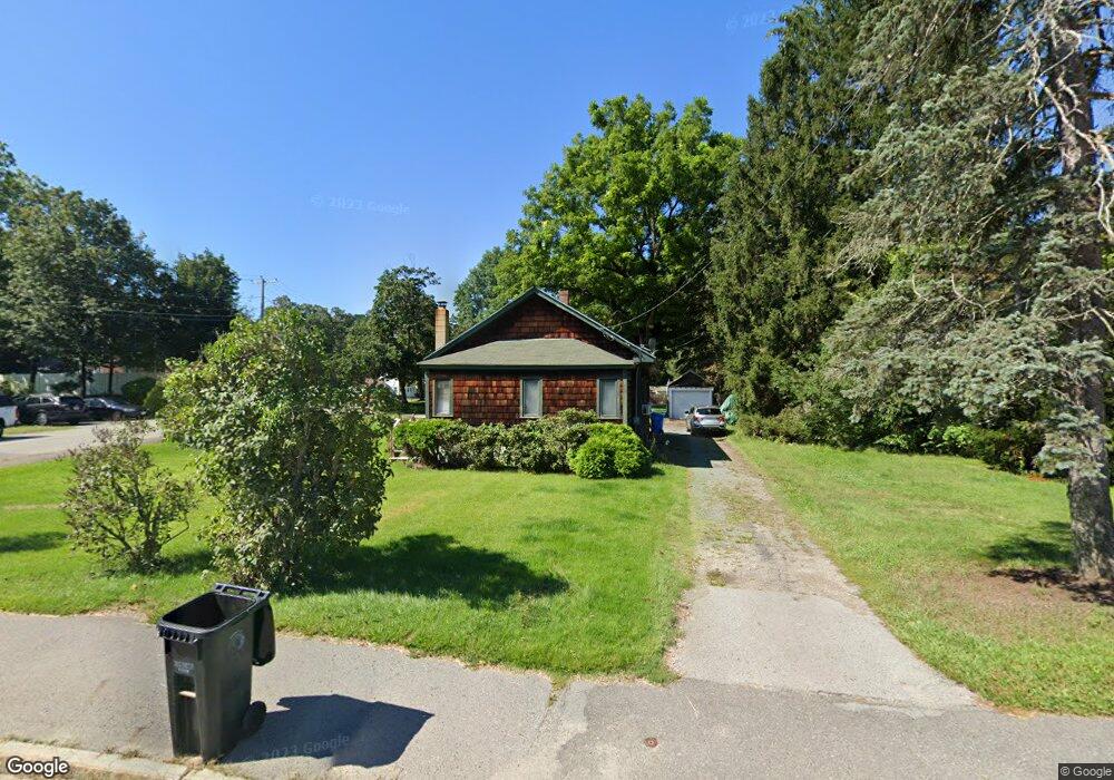
101 Franklin St Wrentham, MA 02093
Estimated Value: $487,439 - $530,000
2
Beds
1
Bath
899
Sq Ft
$565/Sq Ft
Est. Value
About This Home
This home is located at 101 Franklin St, Wrentham, MA 02093 and is currently estimated at $508,110, approximately $565 per square foot. 101 Franklin St is a home located in Norfolk County with nearby schools including Delaney Elementary School and Charles E Roderick.
Ownership History
Date
Name
Owned For
Owner Type
Purchase Details
Closed on
Mar 28, 1997
Sold by
Omalley Martin P and Omalley Clare T
Bought by
Rochefort Sharlene A and Rochefort Paul E
Current Estimated Value
Home Financials for this Owner
Home Financials are based on the most recent Mortgage that was taken out on this home.
Original Mortgage
$111,150
Outstanding Balance
$13,995
Interest Rate
7.59%
Mortgage Type
Purchase Money Mortgage
Estimated Equity
$494,115
Create a Home Valuation Report for This Property
The Home Valuation Report is an in-depth analysis detailing your home's value as well as a comparison with similar homes in the area
Home Values in the Area
Average Home Value in this Area
Purchase History
| Date | Buyer | Sale Price | Title Company |
|---|---|---|---|
| Rochefort Sharlene A | $123,500 | -- |
Source: Public Records
Mortgage History
| Date | Status | Borrower | Loan Amount |
|---|---|---|---|
| Open | Rochefort Sharlene A | $111,150 | |
| Previous Owner | Rochefort Sharlene A | $112,500 | |
| Previous Owner | Rochefort Sharlene A | $91,000 |
Source: Public Records
Tax History Compared to Growth
Tax History
| Year | Tax Paid | Tax Assessment Tax Assessment Total Assessment is a certain percentage of the fair market value that is determined by local assessors to be the total taxable value of land and additions on the property. | Land | Improvement |
|---|---|---|---|---|
| 2025 | $5,197 | $448,400 | $265,900 | $182,500 |
| 2024 | $4,820 | $401,700 | $265,900 | $135,800 |
| 2023 | $4,409 | $349,400 | $232,800 | $116,600 |
| 2022 | $4,716 | $345,000 | $237,800 | $107,200 |
| 2021 | $4,414 | $313,700 | $211,600 | $102,100 |
| 2020 | $3,778 | $265,100 | $161,500 | $103,600 |
| 2019 | $3,609 | $255,600 | $153,800 | $101,800 |
| 2018 | $3,453 | $242,500 | $154,000 | $88,500 |
| 2017 | $3,299 | $231,500 | $151,100 | $80,400 |
| 2016 | $3,222 | $225,600 | $146,700 | $78,900 |
| 2015 | $3,152 | $210,400 | $141,000 | $69,400 |
| 2014 | $3,105 | $202,800 | $135,600 | $67,200 |
Source: Public Records
Map
Nearby Homes
- 10 Nature View Dr
- 15 Nature View Dr
- 270 Dedham St
- 1 Lorraine Metcalf Dr
- 131 Creek St Unit 7
- 570 Franklin St
- 11 Earle Stewart Ln
- 362 East St
- Lot 3 - 14 Earle Stewart Ln
- Lot 1 - Blueberry 2 Car Plan at King Philip Estates
- Lot 8 - Blueberry 2 Car Plan at King Philip Estates
- Lot 6 - Blueberry 3 Car Plan at King Philip Estates
- Lot 2 - Camden 2 Car Plan at King Philip Estates
- Lot 7 - Cedar Plan at King Philip Estates
- Lot 4 - Hemingway 2 Car Plan at King Philip Estates
- Lot 3 - Blueberry 2 Car Plan at King Philip Estates
- 319 Taunton St
- 246 Forest Grove Ave
- 50 Reed Fulton Ave Unit Lot 61
- 3 Oak Rd