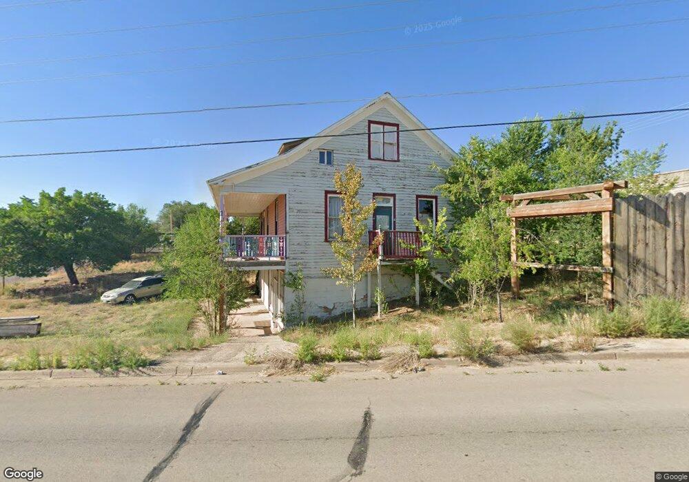
101 Highway 491 Unit Corner of Main & Hwy Dove Creek, CO 81324
Estimated Value: $186,148 - $232,000
2
Beds
2
Baths
1,172
Sq Ft
$179/Sq Ft
Est. Value
About This Home
This home is located at 101 Highway 491 Unit Corner of Main & Hwy, Dove Creek, CO 81324 and is currently estimated at $210,037, approximately $179 per square foot. 101 Highway 491 Unit Corner of Main & Hwy is a home located in Dolores County with nearby schools including Seventh Street Elementary School and Dove Creek High School.
Ownership History
Date
Name
Owned For
Owner Type
Purchase Details
Closed on
Sep 16, 2016
Sold by
Nolan John D
Bought by
La Watha Llc
Current Estimated Value
Home Financials for this Owner
Home Financials are based on the most recent Mortgage that was taken out on this home.
Original Mortgage
$98,276
Outstanding Balance
$78,499
Interest Rate
3.43%
Mortgage Type
Commercial
Estimated Equity
$131,538
Create a Home Valuation Report for This Property
The Home Valuation Report is an in-depth analysis detailing your home's value as well as a comparison with similar homes in the area
Home Values in the Area
Average Home Value in this Area
Purchase History
| Date | Buyer | Sale Price | Title Company |
|---|---|---|---|
| La Watha Llc | $130,000 | None Available |
Source: Public Records
Mortgage History
| Date | Status | Borrower | Loan Amount |
|---|---|---|---|
| Open | La Watha Llc | $98,276 |
Source: Public Records
Tax History Compared to Growth
Tax History
| Year | Tax Paid | Tax Assessment Tax Assessment Total Assessment is a certain percentage of the fair market value that is determined by local assessors to be the total taxable value of land and additions on the property. | Land | Improvement |
|---|---|---|---|---|
| 2024 | $459 | $7,376 | $1,160 | $6,216 |
| 2023 | $458 | $8,292 | $1,243 | $7,049 |
| 2022 | $852 | $8,601 | $1,289 | $7,312 |
| 2021 | $791 | $8,850 | $1,327 | $7,523 |
| 2020 | $800 | $9,056 | $1,327 | $7,729 |
| 2019 | $601 | $10,192 | $1,587 | $8,605 |
| 2018 | $537 | $10,192 | $1,587 | $8,605 |
| 2017 | $611 | $6,715 | $1,587 | $5,128 |
| 2016 | $625 | $6,880 | $1,587 | $5,293 |
| 2015 | -- | $6,880 | $1,587 | $5,293 |
| 2014 | -- | $83,075 | $14,500 | $68,575 |
Source: Public Records
Map
Nearby Homes
- 208 E Highway 491
- 308 E 4th St
- 108 E 5th St
- 404 GUESS Dove St
- 637 Pine St
- 538 W Hwy 491 Hwy
- 9966 Road 7
- TBD Road 7
- 6462 Road L
- TBD Road 12
- 0 Road 12 Unit 827804
- 0 Tbdwp Highway 141
- 12023 Road 12
- 9614 County Road 11 2
- TBDWP County Road M
- 57071 Hwy 491
- 000 Cr K Rd
- 000 Cr K Rd Unit Cross Creek Canyon R
- TBD Road 3
- 11410 Road 12