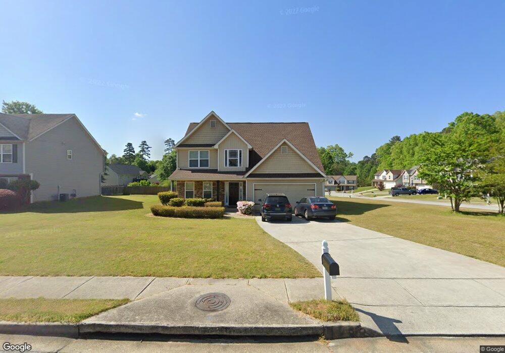
101 Lighthouse Way Winder, GA 30680
Estimated Value: $333,490 - $355,000
4
Beds
3
Baths
1,996
Sq Ft
$173/Sq Ft
Est. Value
About This Home
This home is located at 101 Lighthouse Way, Winder, GA 30680 and is currently estimated at $344,873, approximately $172 per square foot. 101 Lighthouse Way is a home located in Barrow County with nearby schools including Kennedy Elementary School, Westside Middle School, and Apalachee High School.
Ownership History
Date
Name
Owned For
Owner Type
Purchase Details
Closed on
Sep 17, 2009
Sold by
Bryan Sean
Bought by
Peters Kenyata W
Current Estimated Value
Home Financials for this Owner
Home Financials are based on the most recent Mortgage that was taken out on this home.
Original Mortgage
$122,346
Outstanding Balance
$78,871
Interest Rate
5.15%
Mortgage Type
New Conventional
Estimated Equity
$266,002
Purchase Details
Closed on
May 5, 2009
Sold by
Olufemi Stephen
Bought by
Bryan Sean
Purchase Details
Closed on
Aug 19, 2005
Sold by
Damascus Hms Llc
Bought by
Olufemi Stephen
Home Financials for this Owner
Home Financials are based on the most recent Mortgage that was taken out on this home.
Original Mortgage
$121,584
Interest Rate
7.45%
Mortgage Type
New Conventional
Purchase Details
Closed on
Jul 16, 2004
Sold by
Eastside Holdings Llc
Bought by
Damascus Homes Llc
Purchase Details
Closed on
Apr 4, 2003
Bought by
Langley Properties Inc
Create a Home Valuation Report for This Property
The Home Valuation Report is an in-depth analysis detailing your home's value as well as a comparison with similar homes in the area
Home Values in the Area
Average Home Value in this Area
Purchase History
| Date | Buyer | Sale Price | Title Company |
|---|---|---|---|
| Peters Kenyata W | $119,900 | -- | |
| Bryan Sean | $93,601 | -- | |
| Bryan Sean | -- | -- | |
| Olufemi Stephen | $152,000 | -- | |
| Damascus Homes Llc | $38,500 | -- | |
| Langley Properties Inc | -- | -- |
Source: Public Records
Mortgage History
| Date | Status | Borrower | Loan Amount |
|---|---|---|---|
| Open | Peters Kenyata W | $122,346 | |
| Previous Owner | Olufemi Stephen | $121,584 |
Source: Public Records
Tax History
| Year | Tax Paid | Tax Assessment Tax Assessment Total Assessment is a certain percentage of the fair market value that is determined by local assessors to be the total taxable value of land and additions on the property. | Land | Improvement |
|---|---|---|---|---|
| 2025 | $2,787 | $104,615 | $25,600 | $79,015 |
| 2024 | $2,797 | $102,334 | $25,600 | $76,734 |
| 2023 | $2,291 | $101,534 | $24,800 | $76,734 |
| 2022 | $3,094 | $95,498 | $21,600 | $73,898 |
| 2021 | $2,575 | $76,917 | $16,800 | $60,117 |
| 2020 | $2,185 | $67,226 | $14,000 | $53,226 |
| 2019 | $1,987 | $60,336 | $14,000 | $46,336 |
| 2018 | $1,921 | $58,588 | $12,000 | $46,588 |
| 2017 | $1,529 | $51,258 | $12,000 | $39,258 |
| 2016 | $1,364 | $44,394 | $12,000 | $32,394 |
| 2015 | $1,378 | $44,745 | $12,000 | $32,745 |
| 2014 | $1,222 | $40,740 | $7,644 | $33,096 |
| 2013 | -- | $42,029 | $7,644 | $34,385 |
Source: Public Records
Map
Nearby Homes
- 0 Gordon Ct Unit 10634940
- 256 Oceanliner Dr
- 0 Atlanta Hwy SE Unit 10371310
- 1106 Sutherland Dr
- 211 Brooks Ln
- 1102 Sutherland Dr
- 31 Huckleberry Ln
- 252 Eastbrook Dr
- 39 Huckleberry Ln
- 1229 Dianne Dr
- 1230 Dianne Dr
- 194 Graham St
- 184 Capitol Ave
- 163 Wood Cir
- 34 Wade St
- 1048 Sutherland Dr
- 37 Wade St
- 403 Corinth Church Rd
- 24 Richardson St
- 88 E Stephens St
- 103 Lighthouse Way
- 48 Lighthouse Dr
- 105 Lighthouse Way
- 50 Lighthouse Dr
- 45 Lighthouse Dr
- 100 Lighthouse Way
- 43 Lighthouse Dr
- 102 Lighthouse Way
- 47 Lighthouse Dr
- 102 Lighthouse Way
- 41 Lighthouse Dr
- 41 Lighthouse Dr Unit 11
- 57 Oceanliner Trail
- 107 Lighthouse Way
- 58 Oceanliner Trail
- 102 Lighthouse Dr
- 49 Lighthouse Dr
- 104 Lighthouse Way
- 52 Lighthouse Dr
- 39 Lighthouse Dr
Your Personal Tour Guide
Ask me questions while you tour the home.