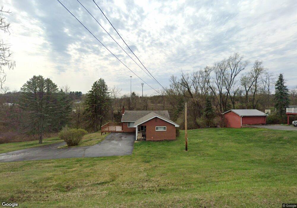
101 Lorish Rd Mc Kees Rocks, PA 15136
Kennedy Township NeighborhoodEstimated Value: $203,000 - $244,000
3
Beds
1
Bath
1,334
Sq Ft
$172/Sq Ft
Est. Value
About This Home
This home is located at 101 Lorish Rd, Mc Kees Rocks, PA 15136 and is currently estimated at $229,662, approximately $172 per square foot. 101 Lorish Rd is a home located in Allegheny County with nearby schools including Montour Elementary School, David E. Williams Middle School, and Montour High School.
Ownership History
Date
Name
Owned For
Owner Type
Purchase Details
Closed on
Jul 13, 2023
Sold by
Colbert Celine Therese and Lusk Robert Harry 3Rd
Bought by
Cusano John Anthony and Yarnot William J
Current Estimated Value
Purchase Details
Closed on
Jun 22, 2023
Sold by
Colbert Celine Therese
Bought by
Yarnot William J
Purchase Details
Closed on
Feb 2, 2022
Sold by
Kohl Sara A Est and Kohl William Albert
Bought by
Lusk Robert Harry 3Rd and Colbert
Purchase Details
Closed on
Jan 26, 2022
Sold by
Kohl Sally Lorish and Kohl William Albert
Bought by
Colbert Celine Therese
Purchase Details
Closed on
Feb 1, 1957
Bought by
Kohl Sally Lorish and William Albert
Create a Home Valuation Report for This Property
The Home Valuation Report is an in-depth analysis detailing your home's value as well as a comparison with similar homes in the area
Home Values in the Area
Average Home Value in this Area
Purchase History
| Date | Buyer | Sale Price | Title Company |
|---|---|---|---|
| Cusano John Anthony | $184,600 | -- | |
| Yarnot William J | $184,600 | -- | |
| Colbert Celine Therese | $125,000 | -- | |
| Kohl Sally Lorish | -- | -- | |
| Lusk Robert Harry 3Rd | -- | -- |
Source: Public Records
Tax History Compared to Growth
Tax History
| Year | Tax Paid | Tax Assessment Tax Assessment Total Assessment is a certain percentage of the fair market value that is determined by local assessors to be the total taxable value of land and additions on the property. | Land | Improvement |
|---|---|---|---|---|
| 2025 | $2,698 | $107,100 | $36,900 | $70,200 |
| 2024 | $2,698 | $107,100 | $36,900 | $70,200 |
| 2023 | $2,682 | $107,100 | $36,900 | $70,200 |
| 2022 | $2,231 | $89,100 | $36,900 | $52,200 |
| 2021 | $2,231 | $89,100 | $36,900 | $52,200 |
| 2020 | $2,231 | $89,100 | $36,900 | $52,200 |
| 2019 | $2,222 | $89,100 | $36,900 | $52,200 |
| 2018 | $2,222 | $89,100 | $36,900 | $52,200 |
| 2017 | $2,200 | $89,100 | $36,900 | $52,200 |
| 2016 | $421 | $89,100 | $36,900 | $52,200 |
| 2015 | $421 | $89,100 | $36,900 | $52,200 |
| 2014 | $2,105 | $89,100 | $36,900 | $52,200 |
Source: Public Records
Map
Nearby Homes
- 2230 McKees Rocks Rd
- 170 Portman St
- 1117 E Windhaven Rd
- 1102 E Windhaven Rd
- 141 Arbor Trail Dr
- 402 Wingate Dr
- 504 Wingate Dr Unit D
- 2033 McKees Rocks Rd
- (Parcel ID# 0205D289 Moon Run Rd
- 5394 Steubenville Pike
- 5575 Aiken Rd
- 11 Truman Cir
- 177 Mccormick Rd
- 313 Blackheath Dr
- 0 Winter Dr
- 5650 Aiken Rd
- 5005 Windover Dr
- 168 Connie Park Dr
- 5100 W Harbison Rd
- 5071 W Harbison Rd