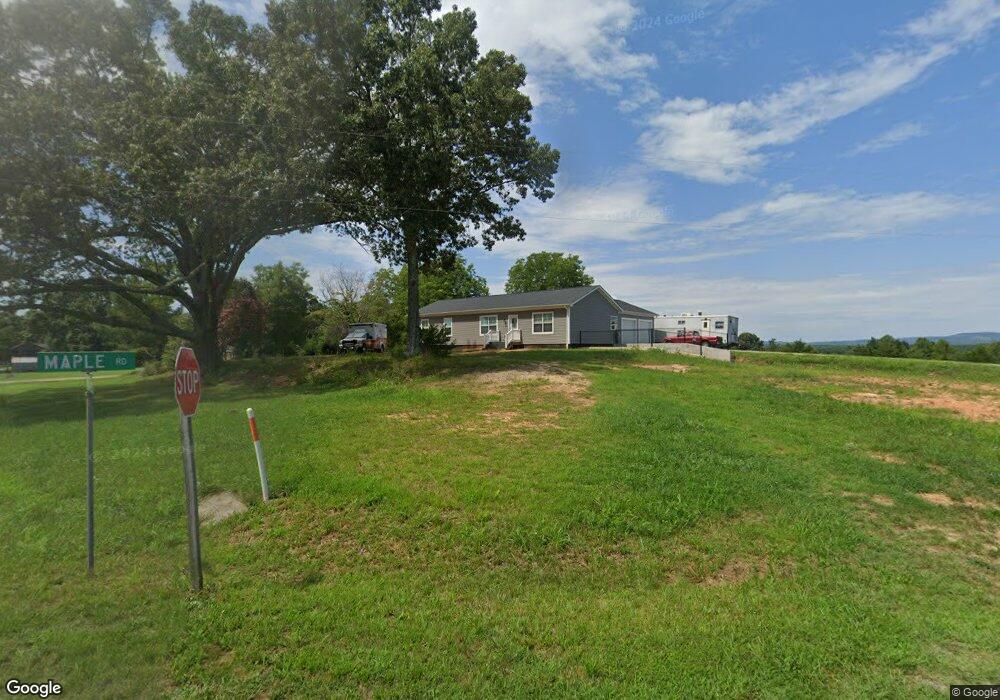
101 Maple Rd Callands, VA 24530
Estimated Value: $178,000 - $411,000
3
Beds
2
Baths
1,560
Sq Ft
$189/Sq Ft
Est. Value
About This Home
This home is located at 101 Maple Rd, Callands, VA 24530 and is currently estimated at $294,500, approximately $188 per square foot. 101 Maple Rd is a home located in Pittsylvania County with nearby schools including Union Hall Elementary School, Chatham Middle School, and Chatham High School.
Ownership History
Date
Name
Owned For
Owner Type
Purchase Details
Closed on
Aug 12, 2022
Sold by
Leon Mccrickard Jr Roger and Leon Sarah E
Bought by
Mccrickard Roger L and Mccrickard Sarah E
Current Estimated Value
Home Financials for this Owner
Home Financials are based on the most recent Mortgage that was taken out on this home.
Original Mortgage
$245,000
Outstanding Balance
$233,988
Interest Rate
5.38%
Mortgage Type
New Conventional
Estimated Equity
$60,512
Purchase Details
Closed on
Nov 18, 2019
Sold by
Mccrickard Roger L and Mccrickard Vicky
Bought by
Mccrickard Roger Leon and Mccrickard Sarah E
Create a Home Valuation Report for This Property
The Home Valuation Report is an in-depth analysis detailing your home's value as well as a comparison with similar homes in the area
Purchase History
| Date | Buyer | Sale Price | Title Company |
|---|---|---|---|
| Mccrickard Roger L | -- | First American Title | |
| Mccrickard Roger Leon | -- | None Available |
Source: Public Records
Mortgage History
| Date | Status | Borrower | Loan Amount |
|---|---|---|---|
| Open | Mccrickard Roger L | $245,000 |
Source: Public Records
Tax History
| Year | Tax Paid | Tax Assessment Tax Assessment Total Assessment is a certain percentage of the fair market value that is determined by local assessors to be the total taxable value of land and additions on the property. | Land | Improvement |
|---|---|---|---|---|
| 2025 | $1,600 | $285,800 | $20,000 | $265,800 |
| 2024 | $1,600 | $285,800 | $20,000 | $265,800 |
| 2023 | $1,600 | $285,800 | $20,000 | $265,800 |
| 2022 | $657 | $86,600 | $20,000 | $66,600 |
| 2021 | $140 | $22,500 | $20,000 | $2,500 |
| 2020 | $140 | $22,500 | $20,000 | $2,500 |
| 2019 | $140 | $22,500 | $20,000 | $2,500 |
| 2018 | $140 | $22,500 | $20,000 | $2,500 |
| 2017 | $109 | $22,500 | $20,000 | $2,500 |
| 2016 | $109 | $18,500 | $15,000 | $3,500 |
| 2015 | $109 | $18,500 | $15,000 | $3,500 |
| 2011 | -- | $17,900 | $14,400 | $3,500 |
Source: Public Records
Map
Nearby Homes
- 17710 Franklin Turnpike
- 17505 Franklin Turnpike
- 1220 Gap Rd
- 2001 Mapleton Dr
- 1104 Union Hall School Rd
- Lot A Callands Rd
- 3732 Water Oak Rd
- 1028 Wyatt Farm Rd
- 133 Drucker Ct
- 0 Wyatt Farm Rd
- 635 High View Ln
- 849 Strawberry Rd
- 8 Whitmell School Rd
- 4161 Wyatt Farm Rd
- 0 Sugar Barbour Rd
- 00 Mount Vernon Rd
- 2640 Brookside Rd
- 233 Gordon Rd
- 375 River Ridge Ln
- 10948 Franklin Turnpike
- 18669 Franklin Turnpike
- 18749 Franklin Turnpike
- 376 Late Rd
- 18617 Franklin Turnpike
- 380 Maple Rd
- 344 Late Rd
- 18804 Franklin Turnpike
- 18548 Franklin Turnpike
- 316 Late Rd
- 000 Franklin Turnpike
- 45 acres Franklin Turnpike
- 00 Franklin Turnpike
- 0 Franklin Turnpike
- 18529 Franklin Turnpike
- 296 Late Rd
- 18457 Franklin Turnpike
- 18985 Franklin Turnpike
- 18980 Franklin Turnpike
- 1972 Parrish Rd
- 18392 Franklin Turnpike
Your Personal Tour Guide
Ask me questions while you tour the home.