
Seller's Agent in 2025
Augie Smith
Coldwell Banker Realty
(860) 558-9683
4 in this area
56 Total Sales
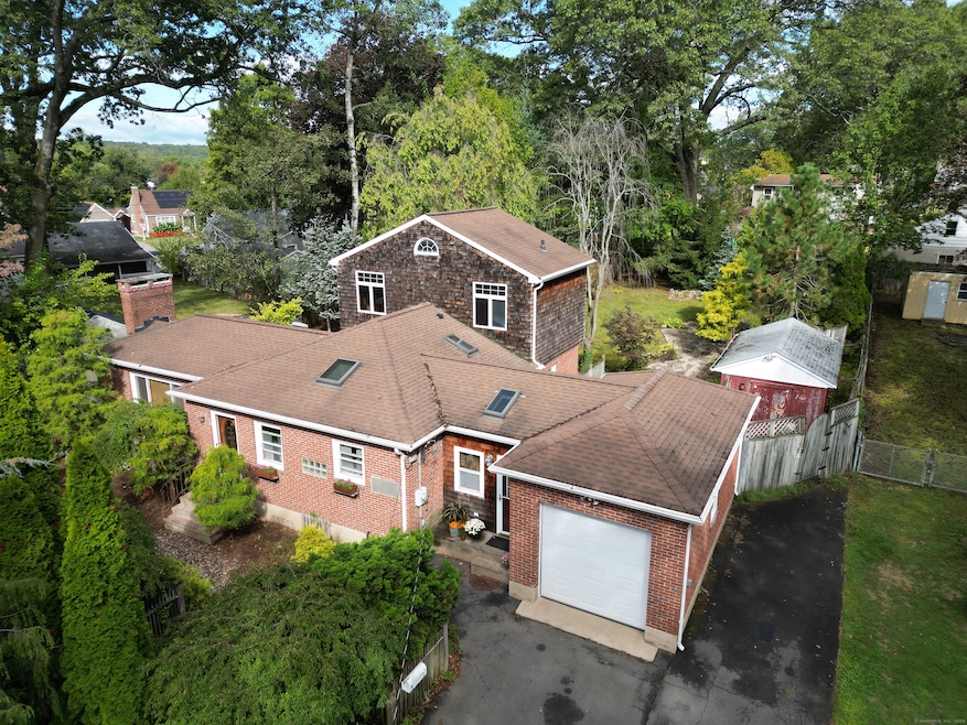
Welcome home to the New Britain, CT gem you have been waiting for. Proudly presenting 101 Maplehurst Avenue, this 3 bed, 1.5 bath ranch offers more than enough room currently, and plenty of potential space for the future. Located seconds from highway access, minutes from West Farms Mall, schools and much more. Upon entering the home you are either greeted to an oversized living room or a den space. Not too far off is a custom kitchen featuring a Sub-Zero fridge, skylight, tiled floors and a eat in area. Down the hallway you have a newly renovated full bath with high ceilings, glassed window, a skylight and a tiled walk in shower. The rest of the first floor comes complete with 2 beds and pristine hardwood floors, all of this is heated by natural gas fueled forced air and there is central air for the cooling. The very unique part of this house lies upstairs with a potential primary bedroom suite. This entire space has been partially finished and is simply waiting for you to add your personal touch, truly so much potential for adding a bed/bath with beautiful bay windows and high ceilings. Heading back over to the den, there is access here to the main house, backyard and garage. The enormous backyard has two sheds, professional landscaping and it is all fenced in for privacy. This home has been cared for so much over the years and I truly believe you will notice. Please take time to consider this care and act quick! Priced at $349,900, inquire today! It will not last!
Last Agent to Sell the Property
Coldwell Banker Realty Brokerage Phone: (860) 558-9683 License #RES.0807346 Listed on: 10/07/2025
| Date | Type | Sale Price | Title Company |
|---|---|---|---|
| Warranty Deed | $365,000 | -- | |
| Deed | $105,000 | -- |
| Date | Status | Loan Amount | Loan Type |
|---|---|---|---|
| Previous Owner | $192,000 | No Value Available | |
| Previous Owner | $100,000 | No Value Available | |
| Previous Owner | $25,000 | No Value Available | |
| Previous Owner | $93,400 | Purchase Money Mortgage |
| Date | Event | Price | List to Sale | Price per Sq Ft |
|---|---|---|---|---|
| 11/19/2025 11/19/25 | Sold | $365,000 | +4.3% | $293 / Sq Ft |
| 10/09/2025 10/09/25 | For Sale | $349,900 | -- | $281 / Sq Ft |
| Year | Tax Paid | Tax Assessment Tax Assessment Total Assessment is a certain percentage of the fair market value that is determined by local assessors to be the total taxable value of land and additions on the property. | Land | Improvement |
|---|---|---|---|---|
| 2025 | $6,818 | $174,020 | $68,040 | $105,980 |
| 2024 | $6,889 | $174,020 | $68,040 | $105,980 |
| 2023 | $6,661 | $174,020 | $68,040 | $105,980 |
| 2022 | $5,617 | $113,470 | $31,360 | $82,110 |
| 2021 | $5,617 | $113,470 | $31,360 | $82,110 |
| 2020 | $5,730 | $113,470 | $31,360 | $82,110 |
| 2019 | $5,730 | $113,470 | $31,360 | $82,110 |
| 2018 | $5,730 | $113,470 | $31,360 | $82,110 |
| 2017 | $5,656 | $112,000 | $26,110 | $85,890 |
| 2016 | $5,656 | $112,000 | $26,110 | $85,890 |
| 2015 | $5,488 | $112,000 | $26,110 | $85,890 |
| 2014 | $5,488 | $112,000 | $26,110 | $85,890 |
Seller's Agent in 2025
Augie Smith
Coldwell Banker Realty
(860) 558-9683
4 in this area
56 Total Sales
Buyer's Agent in 2025
Joseph Snell
Luxe Realty LLC
(860) 839-8331
26 in this area
265 Total Sales
Source: SmartMLS
MLS Number: 24130998
APN: NBRI-000003A-000000-E000045
Disclaimer: Certain information contained herein is derived from information provided by parties other than Homes.com. All information provided is deemed reliable, but is not guaranteed to be accurate and should be independently verified.
![]() IDX information is provided exclusively for personal, non-commercial use, and may not be used for any purpose other than to identify prospective properties consumers may be interested in purchasing. Information is deemed reliable but not guaranteed.
IDX information is provided exclusively for personal, non-commercial use, and may not be used for any purpose other than to identify prospective properties consumers may be interested in purchasing. Information is deemed reliable but not guaranteed.
Ask me questions while you tour the home.