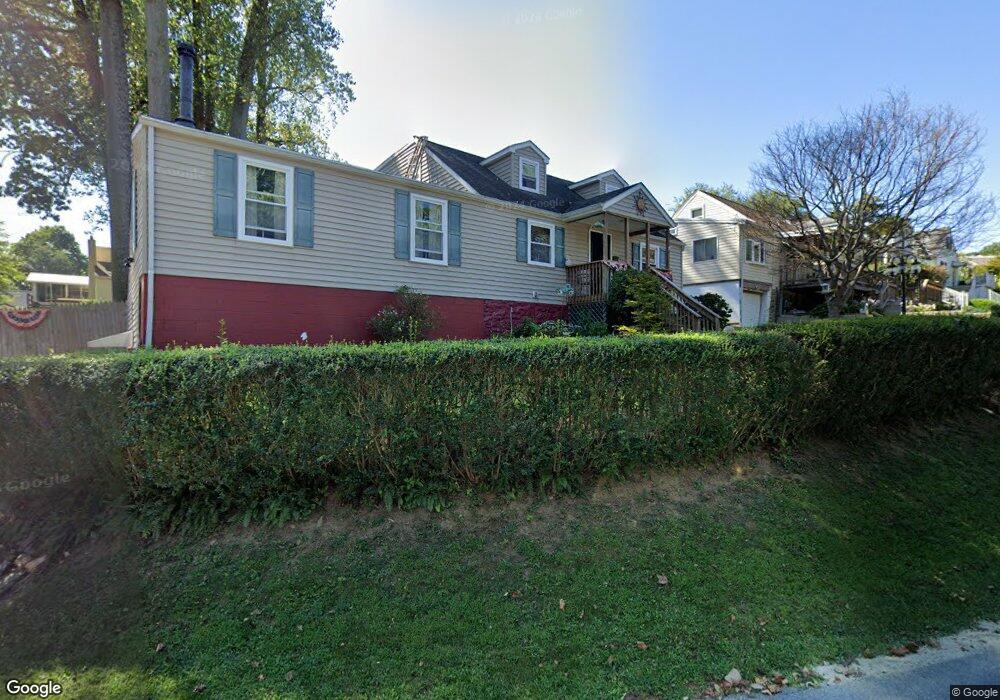
101 Mildred Ln Aston, PA 19014
Estimated Value: $286,000 - $351,000
2
Beds
2
Baths
1,763
Sq Ft
$184/Sq Ft
Est. Value
About This Home
This home is located at 101 Mildred Ln, Aston, PA 19014 and is currently estimated at $323,903, approximately $183 per square foot. 101 Mildred Ln is a home located in Delaware County with nearby schools including The Christian Academy.
Ownership History
Date
Name
Owned For
Owner Type
Purchase Details
Closed on
Oct 16, 2002
Sold by
Kelso David and Kelso Lori
Bought by
Kelso David E and Kelso Lori
Current Estimated Value
Home Financials for this Owner
Home Financials are based on the most recent Mortgage that was taken out on this home.
Original Mortgage
$116,500
Outstanding Balance
$48,984
Interest Rate
6.2%
Mortgage Type
Purchase Money Mortgage
Estimated Equity
$274,919
Purchase Details
Closed on
Mar 27, 2001
Sold by
Finigan John C and Finigan Margaret M
Bought by
Kelso David and Malinak Lori
Home Financials for this Owner
Home Financials are based on the most recent Mortgage that was taken out on this home.
Original Mortgage
$106,400
Interest Rate
6.96%
Mortgage Type
Purchase Money Mortgage
Purchase Details
Closed on
Jan 30, 1996
Sold by
Finigan John C and Finigan Margaret M
Bought by
Finigan John C and Finigan Margaret M
Create a Home Valuation Report for This Property
The Home Valuation Report is an in-depth analysis detailing your home's value as well as a comparison with similar homes in the area
Home Values in the Area
Average Home Value in this Area
Purchase History
| Date | Buyer | Sale Price | Title Company |
|---|---|---|---|
| Kelso David E | -- | -- | |
| Kelso David | $112,000 | T A Title Insurance Co | |
| Finigan John C | -- | T A Title Insurance Company |
Source: Public Records
Mortgage History
| Date | Status | Borrower | Loan Amount |
|---|---|---|---|
| Open | Kelso David E | $116,500 | |
| Closed | Kelso David | $106,400 |
Source: Public Records
Tax History Compared to Growth
Tax History
| Year | Tax Paid | Tax Assessment Tax Assessment Total Assessment is a certain percentage of the fair market value that is determined by local assessors to be the total taxable value of land and additions on the property. | Land | Improvement |
|---|---|---|---|---|
| 2025 | $5,549 | $213,850 | $51,940 | $161,910 |
| 2024 | $5,549 | $213,850 | $51,940 | $161,910 |
| 2023 | $5,300 | $213,850 | $51,940 | $161,910 |
| 2022 | $5,111 | $213,850 | $51,940 | $161,910 |
| 2021 | $7,887 | $213,850 | $51,940 | $161,910 |
| 2020 | $4,323 | $105,840 | $34,660 | $71,180 |
| 2019 | $4,240 | $105,840 | $34,660 | $71,180 |
| 2018 | $4,060 | $105,840 | $0 | $0 |
| 2017 | $3,974 | $105,840 | $0 | $0 |
| 2016 | $581 | $105,840 | $0 | $0 |
| 2015 | $581 | $105,840 | $0 | $0 |
| 2014 | $581 | $105,840 | $0 | $0 |
Source: Public Records
Map
Nearby Homes
- 40 Bunting Ln
- 42 Kingston Terrace
- 3070 Concord Rd
- 4942 Monroe Dr
- 129 Ronald Rd
- 67 Scarlet Ave
- 113 Wellington Rd
- 217 Marianville Rd
- 108 W Knowlton Rd
- 423 Sir Galahad Dr
- 4912 Shepherd St
- 4917 Shepherd St
- 256 Seventh Ave
- 107 Romaine Way
- 4270 Marianne Dr
- 4181 Marianne Dr
- 122 Julianna Way Unit 11
- 150 E Dutton Mill Rd
- 8 Travelo Ln
- 216 Park Dr