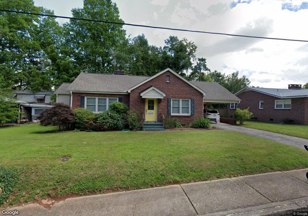
101 S Chestnut St Walhalla, SC 29691
Estimated Value: $138,000 - $212,000
2
Beds
1
Bath
1,199
Sq Ft
$143/Sq Ft
Est. Value
About This Home
This home is located at 101 S Chestnut St, Walhalla, SC 29691 and is currently estimated at $170,866, approximately $142 per square foot. 101 S Chestnut St is a home with nearby schools including James M. Brown Elementary School, Walhalla Middle School, and Walhalla High School.
Ownership History
Date
Name
Owned For
Owner Type
Purchase Details
Closed on
Nov 3, 2009
Sold by
Bodiford John E and Bodiford Kimberly P
Bought by
Ward Barbara Jean
Current Estimated Value
Home Financials for this Owner
Home Financials are based on the most recent Mortgage that was taken out on this home.
Original Mortgage
$76,600
Outstanding Balance
$45,277
Interest Rate
3.37%
Mortgage Type
Adjustable Rate Mortgage/ARM
Estimated Equity
$125,589
Purchase Details
Closed on
Dec 12, 2008
Sold by
Deal S Janice
Bought by
Moss Donna K
Create a Home Valuation Report for This Property
The Home Valuation Report is an in-depth analysis detailing your home's value as well as a comparison with similar homes in the area
Home Values in the Area
Average Home Value in this Area
Purchase History
| Date | Buyer | Sale Price | Title Company |
|---|---|---|---|
| Ward Barbara Jean | $95,750 | -- | |
| Moss Donna K | $40,000 | -- |
Source: Public Records
Mortgage History
| Date | Status | Borrower | Loan Amount |
|---|---|---|---|
| Open | Ward Barbara Jean | $76,600 |
Source: Public Records
Tax History
| Year | Tax Paid | Tax Assessment Tax Assessment Total Assessment is a certain percentage of the fair market value that is determined by local assessors to be the total taxable value of land and additions on the property. | Land | Improvement |
|---|---|---|---|---|
| 2025 | $176 | $2,914 | $488 | $2,426 |
| 2024 | $174 | $2,914 | $488 | $2,426 |
| 2023 | $171 | $2,914 | $488 | $2,426 |
| 2022 | $171 | $2,914 | $488 | $2,426 |
| 2021 | $619 | $2,782 | $488 | $2,294 |
| 2020 | $85 | $2,782 | $488 | $2,294 |
| 2019 | $85 | $0 | $0 | $0 |
| 2018 | $587 | $0 | $0 | $0 |
| 2017 | $619 | $0 | $0 | $0 |
| 2016 | $619 | $0 | $0 | $0 |
| 2015 | -- | $0 | $0 | $0 |
| 2014 | -- | $3,333 | $358 | $2,975 |
| 2013 | -- | $0 | $0 | $0 |
Source: Public Records
Map
Nearby Homes
- 606 W South Broad St
- 107 S Laurel St
- 109 S Laurel St
- 804 W North Broad St
- 318 S Pine St
- 384 E Woodland Dr
- 00 N Church St
- 320 Jaynes St
- 2423 Westminster Hwy
- 223 N Dogwood Dr
- 00 Abbott Ln
- 00 Keowee St
- 606 N Poplar St
- 326 Kenneth St
- 807 W Main St
- 101 Hazelwood Way
- 209 Moore Ave
- 147 White Oak St
- Tract B Bobolink Dr
- 00 Fox Run Rd
- 103 S Chestnut St
- 513 W Main St
- 102 S Chestnut St
- 601 W Main St
- 508 W South Broad St
- 506 W South Broad St
- 509 W Main St
- 504 W South Broad St
- 600 W South Broad St
- 104 S Pine St
- 102 S Pine St Unit and 102-104 Chestnut
- 507 W Main St
- 602 W Main St
- 501 W Main St
- 500 W South Broad St
- 502 W Main St
- 508 W Main St
- 105 S Poplar St
- 103 S Poplar St Unit POPLAR ST
- 103 S Poplar St
Your Personal Tour Guide
Ask me questions while you tour the home.