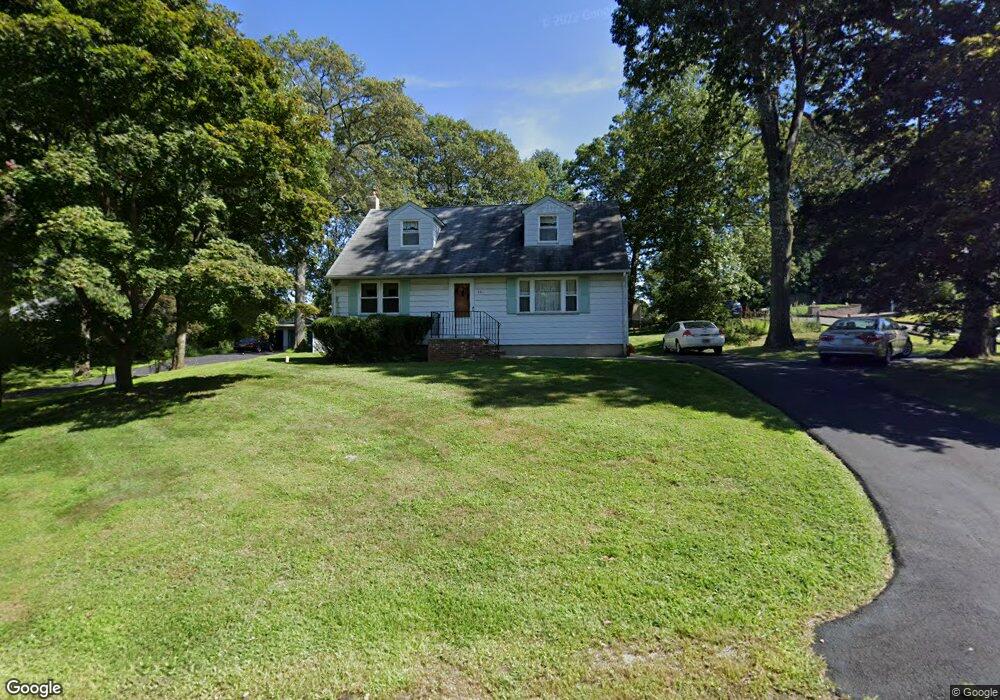
101 Sharp Ave Hopatcong, NJ 07843
Estimated Value: $393,000 - $540,000
--
Bed
--
Bath
1,497
Sq Ft
$304/Sq Ft
Est. Value
About This Home
This home is located at 101 Sharp Ave, Hopatcong, NJ 07843 and is currently estimated at $455,335, approximately $304 per square foot. 101 Sharp Ave is a home located in Sussex County with nearby schools including Hudson Maxim Elementary School, Durban Avenue Elementary School, and Tulsa Trail Elementary School.
Ownership History
Date
Name
Owned For
Owner Type
Purchase Details
Closed on
May 17, 2023
Sold by
Vonderheide Barry W and Vonderheide William J
Bought by
Vonderheide William J and Hartshorn Dianne E
Current Estimated Value
Purchase Details
Closed on
Mar 7, 2013
Sold by
Vonderheidi Doris Jane
Bought by
Vonderheidi William J and Vonderheidi Barry W
Purchase Details
Closed on
Mar 13, 2001
Sold by
Vonderheide Doris Jane
Bought by
Vonderheide Doris Jane
Create a Home Valuation Report for This Property
The Home Valuation Report is an in-depth analysis detailing your home's value as well as a comparison with similar homes in the area
Home Values in the Area
Average Home Value in this Area
Purchase History
| Date | Buyer | Sale Price | Title Company |
|---|---|---|---|
| Vonderheide William J | $200,000 | Atlantic Title | |
| Vonderheidi William J | -- | None Available | |
| Vonderheide Doris Jane | -- | -- |
Source: Public Records
Tax History Compared to Growth
Tax History
| Year | Tax Paid | Tax Assessment Tax Assessment Total Assessment is a certain percentage of the fair market value that is determined by local assessors to be the total taxable value of land and additions on the property. | Land | Improvement |
|---|---|---|---|---|
| 2025 | $6,830 | $327,600 | $138,000 | $189,600 |
| 2024 | $7,250 | $327,600 | $138,000 | $189,600 |
| 2023 | $7,250 | $207,200 | $77,000 | $130,200 |
| 2022 | $7,107 | $207,200 | $77,000 | $130,200 |
| 2021 | $6,987 | $207,200 | $77,000 | $130,200 |
| 2020 | $6,914 | $207,200 | $77,000 | $130,200 |
| 2019 | $6,885 | $207,200 | $77,000 | $130,200 |
| 2018 | $6,871 | $207,200 | $77,000 | $130,200 |
| 2017 | $6,860 | $207,200 | $77,000 | $130,200 |
| 2016 | $6,625 | $207,200 | $77,000 | $130,200 |
| 2015 | $6,470 | $207,200 | $77,000 | $130,200 |
| 2014 | $6,447 | $207,200 | $77,000 | $130,200 |
Source: Public Records
Map
Nearby Homes
- 104 Chincopee Ave
- 109 Durban Ave
- 59 Hopatchung Rd
- 315 Santa fe Trail
- 203 Lakeside Blvd
- 221 Chincopee Ave
- 226 Chincopee Ave
- 8 Cornell Way
- 214 Durban Ave
- 802 Brooklyn Mountain Rd
- 2 Teri Ln
- 328 Tulsa Trail
- 11 Idalroy Trail
- 134 Monroe Trail
- 8 Brooklyn Mountain Rd
- 151 Monroe Trail
- 135 Marla Rd
- 141 W End Ave
- 5 W River Styx Rd Unit 302
- 5 W Unit 204
- 27 Shawnee Rd
- 103 Sharp Ave
- 31 Shawnee Rd
- 32 Shawnee Rd
- 34 Shawnee Rd
- 30 Shawnee Rd
- 36 Shawnee Rd
- 102 Chincopee Ave
- 104 Sharp Ave
- 33 Shawnee Rd
- 38 Shawnee Rd
- 28 Chincopee Ave
- 108 Chincopee Ave
- 26 Chincopee Ave
- 7 Papakating Rd
- 40 Shawnee Rd
- 9 Papakating Rd
- 5 Papakating Rd
- 11 Papakating Rd
- 3 Papakating Rd