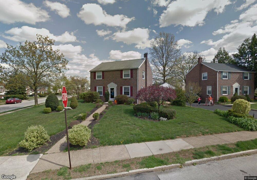
101 West Ave Springfield, PA 19064
Estimated Value: $476,600 - $499,000
3
Beds
2
Baths
1,694
Sq Ft
$290/Sq Ft
Est. Value
About This Home
This home is located at 101 West Ave, Springfield, PA 19064 and is currently estimated at $491,150, approximately $289 per square foot. 101 West Ave is a home located in Delaware County with nearby schools including Springfield High School, Holy Cross School, and St Francis Of Assisi School.
Ownership History
Date
Name
Owned For
Owner Type
Purchase Details
Closed on
Feb 2, 2004
Sold by
Smith Phyllis Margaret and Pisano Phyllis M Smith
Bought by
Orsini John and Orsini Joan
Current Estimated Value
Home Financials for this Owner
Home Financials are based on the most recent Mortgage that was taken out on this home.
Original Mortgage
$198,000
Interest Rate
5.83%
Mortgage Type
Purchase Money Mortgage
Create a Home Valuation Report for This Property
The Home Valuation Report is an in-depth analysis detailing your home's value as well as a comparison with similar homes in the area
Home Values in the Area
Average Home Value in this Area
Purchase History
| Date | Buyer | Sale Price | Title Company |
|---|---|---|---|
| Orsini John | $248,000 | First American Title Ins Co |
Source: Public Records
Mortgage History
| Date | Status | Borrower | Loan Amount |
|---|---|---|---|
| Closed | Orsini John | $198,000 |
Source: Public Records
Tax History
| Year | Tax Paid | Tax Assessment Tax Assessment Total Assessment is a certain percentage of the fair market value that is determined by local assessors to be the total taxable value of land and additions on the property. | Land | Improvement |
|---|---|---|---|---|
| 2025 | $8,272 | $294,300 | $94,530 | $199,770 |
| 2024 | $8,272 | $294,300 | $94,530 | $199,770 |
| 2023 | $7,965 | $294,300 | $94,530 | $199,770 |
| 2022 | $7,793 | $294,300 | $94,530 | $199,770 |
| 2021 | $12,068 | $294,300 | $94,530 | $199,770 |
| 2020 | $6,254 | $138,010 | $45,440 | $92,570 |
| 2019 | $6,107 | $138,010 | $45,440 | $92,570 |
| 2018 | $6,020 | $138,010 | $0 | $0 |
| 2017 | $5,880 | $138,010 | $0 | $0 |
| 2016 | $757 | $138,010 | $0 | $0 |
| 2015 | $757 | $138,010 | $0 | $0 |
| 2014 | $757 | $138,010 | $0 | $0 |
Source: Public Records
Map
Nearby Homes
- 514 Springview Ln
- 624 E Springfield Rd
- 107 N Bishop Ave
- 207 N Bishop Ave
- 225 N Bishop Ave
- 354 E Springfield Rd
- 616 Wayne Ave
- 401 N Sycamore Ave
- 838 West Ave
- 465 Hawarden Rd
- 472 Larchwood Rd
- 424 N Springfield Rd
- 343 Westpark Ln
- 325 Westpark Ln
- 399 N Sycamore Ave
- 265 W Wyncliffe Ave
- 251 Revere Rd
- 329 N Oak Ave
- 270 Davis Ave
- 250 Davis Ave
Your Personal Tour Guide
Ask me questions while you tour the home.