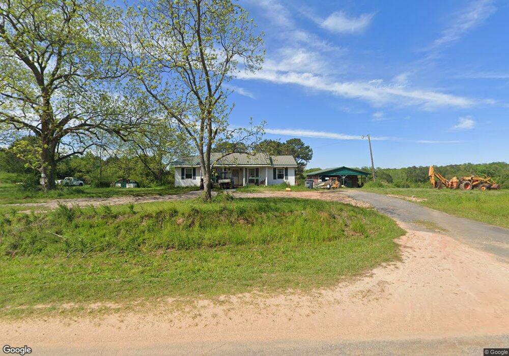
101 Willis Rd the Rock, GA 30285
Estimated Value: $300,000 - $909,393
2
Beds
1
Bath
1,062
Sq Ft
$525/Sq Ft
Est. Value
About This Home
This home is located at 101 Willis Rd, the Rock, GA 30285 and is currently estimated at $557,098, approximately $524 per square foot. 101 Willis Rd is a home with nearby schools including Lamar County Primary School, Lamar County Elementary School, and Lamar County Middle School.
Ownership History
Date
Name
Owned For
Owner Type
Purchase Details
Closed on
Dec 11, 2024
Sold by
Brooke Roger Gordon
Bought by
Brooke Brantley Taylor and Brooke Roger Eric
Current Estimated Value
Purchase Details
Closed on
Dec 22, 2015
Sold by
Brooke Robert E
Bought by
Brooke Roger G
Purchase Details
Closed on
Mar 29, 2010
Sold by
Brooke E Robert
Bought by
Brooke Robert E
Purchase Details
Closed on
Dec 7, 1982
Sold by
Ware Solon W and Ware Jr
Bought by
Brooke E Robert
Purchase Details
Closed on
Feb 1, 1973
Sold by
Davis E R
Bought by
Brooke Robert E Mrs
Create a Home Valuation Report for This Property
The Home Valuation Report is an in-depth analysis detailing your home's value as well as a comparison with similar homes in the area
Purchase History
| Date | Buyer | Sale Price | Title Company |
|---|---|---|---|
| Brooke Brantley Taylor | -- | -- | |
| Brooke Roger G | $175,000 | -- | |
| Brooke Roger G | -- | -- | |
| Brooke Robert E | -- | -- | |
| Brooke E Robert | $4,000 | -- | |
| Brooke Robert E Mrs | $110,600 | -- |
Source: Public Records
Tax History
| Year | Tax Paid | Tax Assessment Tax Assessment Total Assessment is a certain percentage of the fair market value that is determined by local assessors to be the total taxable value of land and additions on the property. | Land | Improvement |
|---|---|---|---|---|
| 2025 | $2,461 | $265,334 | $190,816 | $74,518 |
| 2024 | $2,396 | $253,050 | $190,816 | $62,234 |
| 2023 | $2,467 | $250,112 | $190,816 | $59,296 |
| 2022 | $2,259 | $195,227 | $142,166 | $53,061 |
| 2021 | $1,762 | $169,160 | $142,166 | $26,994 |
| 2020 | $1,836 | $175,700 | $148,706 | $26,994 |
| 2019 | $1,687 | $175,626 | $148,632 | $26,994 |
| 2018 | $0 | $175,626 | $148,632 | $26,994 |
| 2017 | $1,548 | $175,626 | $148,632 | $26,994 |
| 2016 | $1,939 | $175,626 | $148,632 | $26,994 |
| 2015 | $1,537 | $186,068 | $156,063 | $30,004 |
| 2014 | $1,466 | $186,068 | $156,063 | $30,004 |
| 2013 | -- | $186,067 | $156,063 | $30,004 |
Source: Public Records
Map
Nearby Homes
- 0 Barnesville Hwy Unit 10548523
- 2222 Barnesville Hwy
- 61 ACRES Barnesville Hwy
- 98 Mud Bridge Rd
- 0 Perkins Rd Unit 253616
- 0 Perkins Rd Unit 10699928
- 0 Perkins Rd Unit 10625263
- 0 Perkins Rd Unit 7692755
- 1972 Rest Haven Rd
- 216 Ponderosa Ln
- Race Track Rd
- 1907 Rocky Bottom Rd
- 1961 Rocky Bottom Rd
- 63 Alabama Rd
- 2200 Rest Haven Rd
- 146 Berry Rd Unit LOT 12B
- 148 Berry Rd Unit LOT 12A
- 144 Berry Rd Unit LOT 13
- 150 Berry Rd
- 475 Piedmont Rd
- 0 Willis Rd -B-3 Unit 20104368
- 260 Willis Rd
- 272 Willis Rd
- 280 Willis Rd
- 246 Willis Rd
- 242 Willis Rd
- 928 Piedmont Rd
- 0 Lindsey Rd Unit 8403737
- 0 Lindsey Rd Unit 8401287
- 0 Lindsey Rd Unit 3015866
- 0 Lindsey Rd Unit 7087858
- 0 Lindsey Rd Unit 7208197
- 0 Lindsey Rd Unit 7492895
- 0 Lindsey Rd Unit 8153029
- 0 Lindsey Rd Unit 9020875
- 193 Lindsey Rd
- 199 Lindsey Rd
- 212 Lindsey Rd
- 632 Willis Rd
- 692 Willis Rd
Your Personal Tour Guide
Ask me questions while you tour the home.