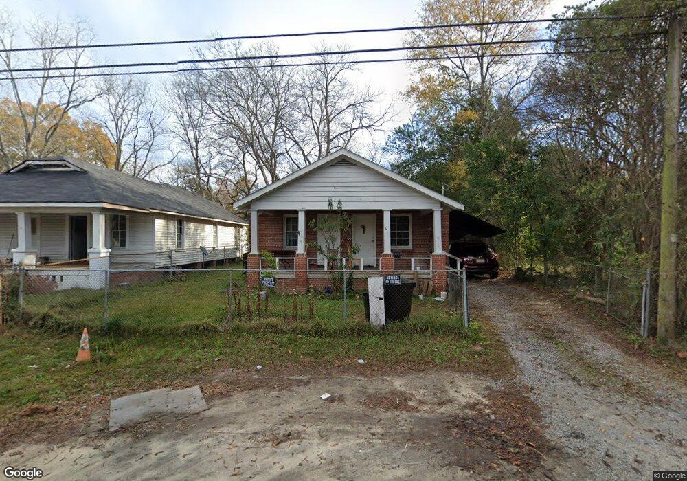
1010 Benning Dr Columbus, GA 31903
Estimated Value: $35,000 - $63,841
3
Beds
2
Baths
1,120
Sq Ft
$41/Sq Ft
Est. Value
About This Home
This home is located at 1010 Benning Dr, Columbus, GA 31903 and is currently estimated at $45,460, approximately $40 per square foot. 1010 Benning Dr is a home located in Muscogee County with nearby schools including Dorothy Height Elementary School, Baker Middle School, and Spencer High School.
Ownership History
Date
Name
Owned For
Owner Type
Purchase Details
Closed on
Sep 1, 2022
Sold by
James Evans Robert
Bought by
Ahmed Meryem
Current Estimated Value
Purchase Details
Closed on
Sep 10, 2010
Sold by
Branch Banking & Trust Company
Bought by
Evans Robert
Purchase Details
Closed on
Mar 8, 2010
Sold by
Mid South Rentals Llc
Bought by
Branch Banking & Trust Company
Create a Home Valuation Report for This Property
The Home Valuation Report is an in-depth analysis detailing your home's value as well as a comparison with similar homes in the area
Home Values in the Area
Average Home Value in this Area
Purchase History
| Date | Buyer | Sale Price | Title Company |
|---|---|---|---|
| Ahmed Meryem | $34,000 | -- | |
| Evans Robert | $19,900 | None Available | |
| Branch Banking & Trust Company | $10,000 | None Available |
Source: Public Records
Tax History Compared to Growth
Tax History
| Year | Tax Paid | Tax Assessment Tax Assessment Total Assessment is a certain percentage of the fair market value that is determined by local assessors to be the total taxable value of land and additions on the property. | Land | Improvement |
|---|---|---|---|---|
| 2025 | $535 | $13,676 | $4,132 | $9,544 |
| 2024 | -- | $13,676 | $4,132 | $9,544 |
| 2023 | $539 | $13,676 | $4,132 | $9,544 |
| 2022 | $191 | $4,668 | $4,132 | $536 |
| 2021 | $155 | $3,788 | $3,788 | $0 |
| 2020 | $155 | $3,788 | $3,788 | $0 |
| 2019 | $387 | $9,450 | $2,362 | $7,088 |
| 2018 | $387 | $9,450 | $2,362 | $7,088 |
| 2017 | $388 | $9,450 | $2,362 | $7,088 |
| 2016 | $432 | $10,477 | $1,400 | $9,077 |
| 2015 | $433 | $10,477 | $1,400 | $9,077 |
| 2014 | $248 | $6,000 | $0 | $0 |
| 2013 | $248 | $6,000 | $0 | $0 |
Source: Public Records
Map
Nearby Homes
- 1025 Fletcher Ave
- 917 Fletcher Ave
- 906 Winston Rd
- 824 Winston Rd
- 812 Benning Dr
- 903 Winston Rd
- 920 Brooks Rd
- 750 Winston Rd
- 716 Benning Dr
- 1029 Harbison Dr
- 3135 Baker Cir
- 3111 Baker Cir
- 3223 Lee St
- 1401 Clark Ave
- 1274 Providence Ln
- 2459 Brownie Ln
- 2463 Brownie Ln
- 2451 Brownie Ln
- 184 30th Ave
- 2916 Lee St
- 1006 Benning Dr
- 1018 Benning Dr
- 928 Benning Dr
- 1011 Fletcher Ave
- 1020 Benning Dr
- 1003 Fletcher Ave
- 1013 Fletcher Ave
- 1001 Fletcher Ave
- 1017 Fletcher Ave
- 926 Benning Dr
- 1026 Benning Dr
- 1023 Fletcher Ave
- 929 Fletcher Ave
- 1007 Benning Dr
- 1017 Benning Dr
- 933 Benning Dr
- 1021 Fletcher Ave
- 925 Fletcher Ave
- 920 Benning Dr
- 931 Benning Dr