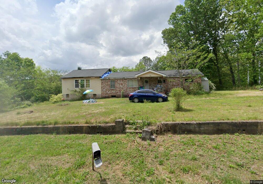
1010 Crest Dr La Fayette, GA 30728
Estimated Value: $113,000 - $170,000
3
Beds
1
Bath
1,664
Sq Ft
$88/Sq Ft
Est. Value
About This Home
This home is located at 1010 Crest Dr, La Fayette, GA 30728 and is currently estimated at $146,318, approximately $87 per square foot. 1010 Crest Dr is a home located in Walker County with nearby schools including North Lafayette Elementary School, Lafayette Middle School, and Lafayette High School.
Ownership History
Date
Name
Owned For
Owner Type
Purchase Details
Closed on
Feb 23, 2024
Sold by
Johnson Dianne
Bought by
Bowling Misty
Current Estimated Value
Purchase Details
Closed on
Aug 27, 2009
Sold by
Whitley William B
Bought by
Johnson Dianne
Purchase Details
Closed on
May 29, 2009
Sold by
Burks Ernestine
Bought by
Whitley William B
Purchase Details
Closed on
Apr 17, 2009
Sold by
Ficken Ken
Bought by
Burks Ernestine
Purchase Details
Closed on
Mar 26, 2008
Sold by
Not Provided
Bought by
Mortgage Electronic Registra and Tion Systems Inc Acting
Purchase Details
Closed on
Jan 1, 1972
Bought by
Burns Betty
Create a Home Valuation Report for This Property
The Home Valuation Report is an in-depth analysis detailing your home's value as well as a comparison with similar homes in the area
Home Values in the Area
Average Home Value in this Area
Purchase History
| Date | Buyer | Sale Price | Title Company |
|---|---|---|---|
| Bowling Misty | -- | -- | |
| Johnson Dianne | $41,000 | -- | |
| Whitley William B | $38,000 | -- | |
| Burks Ernestine | $34,000 | -- | |
| Mortgage Electronic Registra | -- | -- | |
| Burns Betty | -- | -- |
Source: Public Records
Tax History Compared to Growth
Tax History
| Year | Tax Paid | Tax Assessment Tax Assessment Total Assessment is a certain percentage of the fair market value that is determined by local assessors to be the total taxable value of land and additions on the property. | Land | Improvement |
|---|---|---|---|---|
| 2024 | $961 | $40,345 | $5,821 | $34,524 |
| 2023 | $942 | $38,379 | $5,781 | $32,598 |
| 2022 | $882 | $33,519 | $5,781 | $27,738 |
| 2021 | $986 | $33,573 | $5,781 | $27,792 |
| 2020 | $884 | $28,813 | $5,781 | $23,032 |
| 2019 | $884 | $28,813 | $5,781 | $23,032 |
| 2018 | $857 | $28,813 | $5,781 | $23,032 |
| 2017 | $958 | $28,813 | $5,781 | $23,032 |
| 2016 | $794 | $28,813 | $5,781 | $23,032 |
| 2015 | $712 | $24,615 | $6,844 | $17,771 |
| 2014 | $686 | $24,615 | $6,844 | $17,771 |
| 2013 | -- | $24,614 | $6,844 | $17,770 |
Source: Public Records
Map
Nearby Homes
- 0 Crest Dr Unit 10628988
- 0 Crest Dr Unit 1522720
- 1299 Trion Hwy
- 27 Foster
- 78 Lake Terrace Dr
- 2 Skyline Heights
- 140 Bryant Ave
- 2280 S Highway S 27
- 154 Skyline Heights
- 2280 Highway S 27
- 91 Lee Edwards Dr
- 91 Lee Edwards Dr
- 307 S Duke St
- 216 Thurman St
- Curtis Plan at Lake Terrace
- Perry Plan at Lake Terrace
- Edmon Plan at Lake Terrace
- Lewis Plan at Lake Terrace
- Wyeth Plan at Lake Terrace
- Sullivan Plan at Lake Terrace