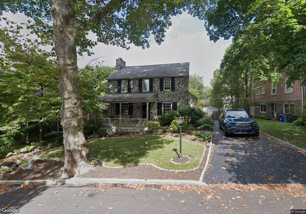
1010 Hampstead Rd Wynnewood, PA 19096
Estimated Value: $552,000 - $647,000
3
Beds
2
Baths
1,708
Sq Ft
$347/Sq Ft
Est. Value
About This Home
This home is located at 1010 Hampstead Rd, Wynnewood, PA 19096 and is currently estimated at $593,442, approximately $347 per square foot. 1010 Hampstead Rd is a home located in Delaware County with nearby schools including Chatham Park Elementary School, Haverford Middle School, and Haverford Senior High School.
Ownership History
Date
Name
Owned For
Owner Type
Purchase Details
Closed on
May 27, 2003
Sold by
Zorc Joseph J and Kraft Judith E
Bought by
Martinko Lisa A
Current Estimated Value
Home Financials for this Owner
Home Financials are based on the most recent Mortgage that was taken out on this home.
Original Mortgage
$232,000
Interest Rate
5.86%
Mortgage Type
Purchase Money Mortgage
Purchase Details
Closed on
Jul 21, 1998
Sold by
Tocci Gary M and Lloyd Elizabeth A
Bought by
Kraft Judith E and Zorc Joseph J
Home Financials for this Owner
Home Financials are based on the most recent Mortgage that was taken out on this home.
Original Mortgage
$180,800
Interest Rate
6.92%
Create a Home Valuation Report for This Property
The Home Valuation Report is an in-depth analysis detailing your home's value as well as a comparison with similar homes in the area
Home Values in the Area
Average Home Value in this Area
Purchase History
| Date | Buyer | Sale Price | Title Company |
|---|---|---|---|
| Martinko Lisa A | $309,000 | -- | |
| Kraft Judith E | $226,000 | Commonwealth Land Title Ins |
Source: Public Records
Mortgage History
| Date | Status | Borrower | Loan Amount |
|---|---|---|---|
| Closed | Martinko Lisa A | $232,000 | |
| Previous Owner | Kraft Judith E | $180,800 |
Source: Public Records
Tax History Compared to Growth
Tax History
| Year | Tax Paid | Tax Assessment Tax Assessment Total Assessment is a certain percentage of the fair market value that is determined by local assessors to be the total taxable value of land and additions on the property. | Land | Improvement |
|---|---|---|---|---|
| 2025 | $7,789 | $302,930 | $98,490 | $204,440 |
| 2024 | $7,789 | $302,930 | $98,490 | $204,440 |
| 2023 | $7,568 | $302,930 | $98,490 | $204,440 |
| 2022 | $7,391 | $302,930 | $98,490 | $204,440 |
| 2021 | $12,041 | $302,930 | $98,490 | $204,440 |
| 2020 | $7,300 | $157,070 | $49,870 | $107,200 |
| 2019 | $7,166 | $157,070 | $49,870 | $107,200 |
| 2018 | $7,043 | $157,070 | $0 | $0 |
| 2017 | $6,894 | $157,070 | $0 | $0 |
| 2016 | $862 | $157,070 | $0 | $0 |
| 2015 | $880 | $157,070 | $0 | $0 |
| 2014 | $862 | $157,070 | $0 | $0 |
Source: Public Records
Map
Nearby Homes
- 758 Lawson Ave
- 212 Henley Rd
- 755 Lawson Ave
- 1455 Braddock Ln
- 243 Rock Glen Rd
- 109 Overbrook Pkwy
- 633 E Manoa Rd
- 611 Penfield Ave
- 628 Lawson Ave
- 249 Haverford Rd
- 26 Henley Rd
- 520 Twin Oaks Dr
- 978 Township Line Rd
- 529 Covington Rd
- 1504 Sheffield Ln
- 501 E Manoa Rd
- 1319 Remington Rd
- 304 Earlington Rd
- 1406 Greywall Ln
- 433 Haverford Rd
- 1008 Hampstead Rd
- 1012 Hampstead Rd
- 804 Dover Rd
- 1006 Hampstead Rd
- 1007 Aikens Ln
- 1009 Hampstead Rd
- 1011 Hampstead Rd
- 806 Dover Rd
- 1004 Hampstead Rd
- 1007 Hampstead Rd
- 715 Dover Rd
- 801 Dover Rd
- 1003 Aikens Ln
- 713 Dover Rd
- 808 Dover Rd
- 1009 Aikens Ln
- 803 Dover Rd
- 1005 Hampstead Rd
- 1002 Hampstead Rd
- 711 Dover Rd