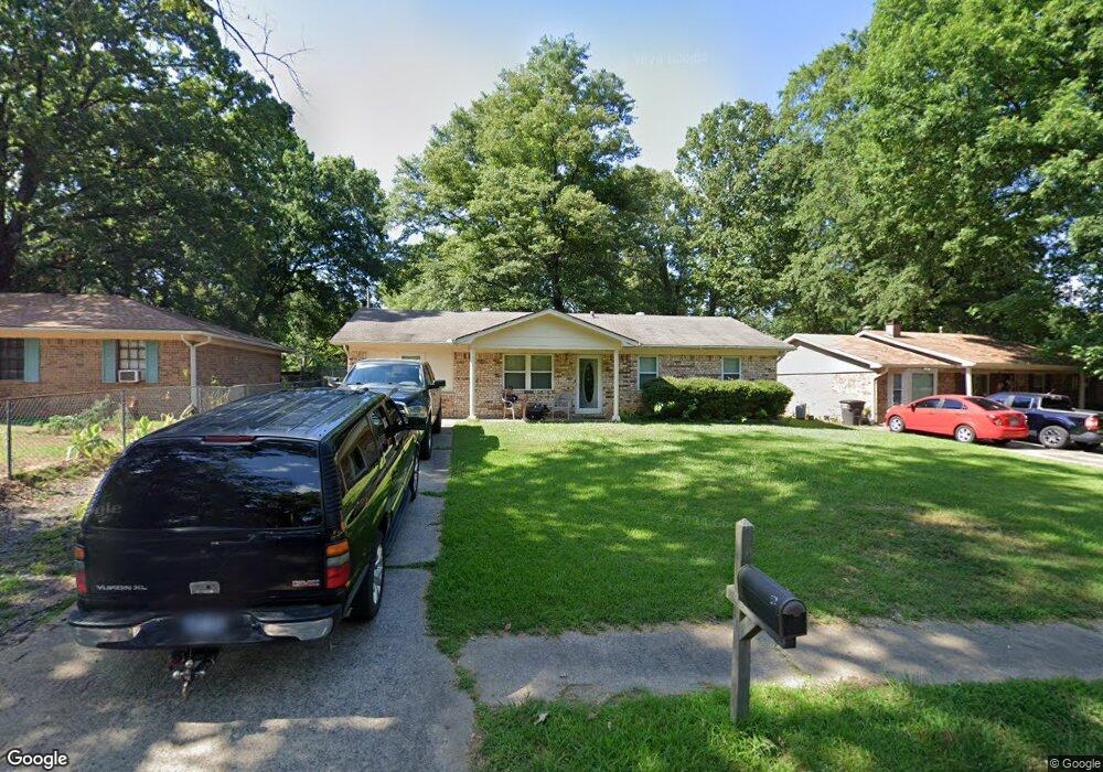
1010 Liberty Dr Jacksonville, AR 72076
Estimated Value: $133,374 - $151,000
--
Bed
3
Baths
1,421
Sq Ft
$99/Sq Ft
Est. Value
About This Home
This home is located at 1010 Liberty Dr, Jacksonville, AR 72076 and is currently estimated at $140,344, approximately $98 per square foot. 1010 Liberty Dr is a home located in Pulaski County with nearby schools including Murrell Taylor Elementary School, Jacksonville Middle School, and Jacksonville High School.
Ownership History
Date
Name
Owned For
Owner Type
Purchase Details
Closed on
Apr 16, 2007
Sold by
Mccormick Douglas K and Mccormick Enterprises Llc
Bought by
Wood Amy
Current Estimated Value
Home Financials for this Owner
Home Financials are based on the most recent Mortgage that was taken out on this home.
Original Mortgage
$90,500
Outstanding Balance
$54,719
Interest Rate
6.15%
Mortgage Type
Purchase Money Mortgage
Estimated Equity
$85,625
Purchase Details
Closed on
Mar 3, 2005
Sold by
Hud
Bought by
Mccormick Douglas K and Mccormick Enterprises Llc
Home Financials for this Owner
Home Financials are based on the most recent Mortgage that was taken out on this home.
Original Mortgage
$38,900
Interest Rate
5.71%
Mortgage Type
Purchase Money Mortgage
Purchase Details
Closed on
Sep 15, 2004
Sold by
Chase Manhattan Mortgage Corp
Bought by
Hud
Create a Home Valuation Report for This Property
The Home Valuation Report is an in-depth analysis detailing your home's value as well as a comparison with similar homes in the area
Home Values in the Area
Average Home Value in this Area
Purchase History
| Date | Buyer | Sale Price | Title Company |
|---|---|---|---|
| Wood Amy | $91,000 | First National Title Company | |
| Mccormick Douglas K | -- | Three Rivers Title Services | |
| Hud | -- | -- |
Source: Public Records
Mortgage History
| Date | Status | Borrower | Loan Amount |
|---|---|---|---|
| Open | Wood Amy | $90,500 | |
| Previous Owner | Mccormick Douglas K | $38,900 |
Source: Public Records
Tax History Compared to Growth
Tax History
| Year | Tax Paid | Tax Assessment Tax Assessment Total Assessment is a certain percentage of the fair market value that is determined by local assessors to be the total taxable value of land and additions on the property. | Land | Improvement |
|---|---|---|---|---|
| 2025 | $1,219 | $20,092 | $1,200 | $18,892 |
| 2024 | $916 | $20,092 | $1,200 | $18,892 |
| 2023 | $916 | $20,092 | $1,200 | $18,892 |
| 2022 | $914 | $20,092 | $1,200 | $18,892 |
| 2021 | $871 | $14,180 | $740 | $13,440 |
| 2020 | $496 | $14,180 | $740 | $13,440 |
| 2019 | $496 | $14,180 | $740 | $13,440 |
| 2018 | $521 | $14,180 | $740 | $13,440 |
| 2017 | $521 | $14,180 | $740 | $13,440 |
| 2016 | $632 | $15,990 | $2,600 | $13,390 |
| 2015 | $860 | $15,990 | $2,600 | $13,390 |
| 2014 | $860 | $15,990 | $2,600 | $13,390 |
Source: Public Records
Map
Nearby Homes
- 1008 Liberty Dr
- 1014 Liberty Dr
- 1007 Oneal St
- 1004 Liberty Dr
- 1 Nathan Hale St
- 1013 O'Neal St
- 1013 Oneal St
- 2 Nathan Hale St
- 1134 Casey St
- 1006 Oneal St
- 40 Woodbriar Dr
- 1008 Oneal St
- 1000 Liberty Dr
- 1002 Oneal St
- 1013 Liberty Dr
- 1101 Liberty Dr
- 0 O'Neal St Unit 20029331
- 0 O'Neal St Unit 18003888
- 1010 Oneal St
- 2 Woodbriar Ct