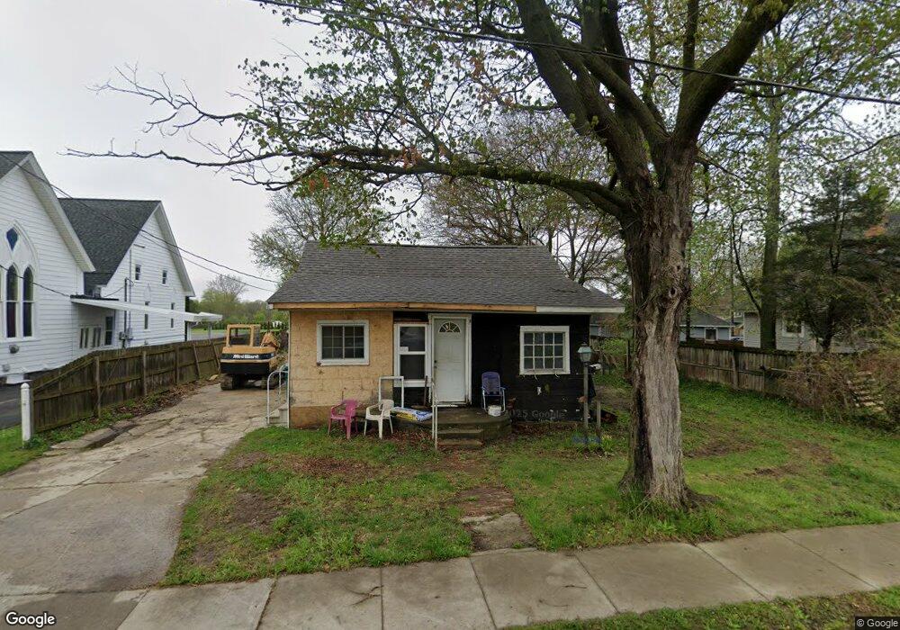
1010 Oak St Lennon, MI 48449
Venice Township NeighborhoodEstimated Value: $87,104 - $189,000
3
Beds
1
Bath
1,200
Sq Ft
$120/Sq Ft
Est. Value
About This Home
This home is located at 1010 Oak St, Lennon, MI 48449 and is currently estimated at $144,026, approximately $120 per square foot. 1010 Oak St is a home located in Shiawassee County with nearby schools including Bertha Neal Elementary School, Robert Kerr School, and Durand Middle School.
Ownership History
Date
Name
Owned For
Owner Type
Purchase Details
Closed on
Apr 9, 2024
Sold by
Garant Donald W and Garant Laurie A
Bought by
Maier Randy R and Maier Tamala Ann
Current Estimated Value
Purchase Details
Closed on
Sep 2, 2005
Sold by
Bauer Richard J and Bauer Jean
Bought by
Garant Donald W and Garant Laurie A
Purchase Details
Closed on
Dec 22, 2004
Sold by
Estate Of Elvin D Brittain and Woodworth Rosemary E
Bought by
Bauer Richard J
Purchase Details
Closed on
Mar 26, 2003
Sold by
Brittain Mary L
Bought by
Brittain Elvin D and Brittain Mary L
Create a Home Valuation Report for This Property
The Home Valuation Report is an in-depth analysis detailing your home's value as well as a comparison with similar homes in the area
Home Values in the Area
Average Home Value in this Area
Purchase History
| Date | Buyer | Sale Price | Title Company |
|---|---|---|---|
| Maier Randy R | $6,000 | Cislo Title Company | |
| Garant Donald W | -- | -- | |
| Bauer Richard J | $35,000 | -- | |
| Brittain Elvin D | -- | -- | |
| Woodworth Rosemary E | -- | -- |
Source: Public Records
Tax History Compared to Growth
Tax History
| Year | Tax Paid | Tax Assessment Tax Assessment Total Assessment is a certain percentage of the fair market value that is determined by local assessors to be the total taxable value of land and additions on the property. | Land | Improvement |
|---|---|---|---|---|
| 2025 | $1,176 | $19,500 | $0 | $0 |
| 2024 | $1,104 | $55,500 | $0 | $0 |
| 2023 | $251 | $46,300 | $0 | $0 |
| 2022 | $1,432 | $37,800 | $0 | $0 |
| 2021 | $1,665 | $35,300 | $0 | $0 |
| 2020 | $1,798 | $35,300 | $0 | $0 |
| 2019 | $1,532 | $23,400 | $0 | $0 |
| 2018 | $1,765 | $23,200 | $0 | $0 |
| 2017 | $1,082 | $21,000 | $0 | $0 |
| 2016 | $508 | $21,000 | $0 | $0 |
| 2015 | $508 | $20,100 | $0 | $0 |
| 2014 | $101 | $19,300 | $0 | $0 |
Source: Public Records
Map
Nearby Homes
- 805 Oak St
- V/L S Sheridan Rd
- 2548 S Sheridan Rd
- 11295 E Lytle Rd
- 1936 Elmwood Dr
- 12502 W Corunna Rd
- TBD E Brooks Rd N of Us 69 W of M13
- 4101 lot 171 S Sheridan
- 4101 S Sheridan Rd Unit 132
- 4014 S Duffield Rd
- 11424 Corunna Rd
- 9895 E Brooks Rd
- 11415 Miller Rd
- 9508 E Lytle Rd
- 2135 S New Lothrop Rd
- 1475 S Nichols Rd
- 10001 Goodall Unit 77
- 11637 E Lansing Rd
- 5051 Nichols Rd
- 10141 McEnrue Rd
- 1016 Oak St
- Vacant Land Lennon Rd
- 1018 Oak St
- 11715 E Lennon Rd
- 1026 Oak St
- 1026 Oak St
- 1026 Oak St
- 1013 Oak St
- 11647 E Lennon Rd
- 11645 E Lennon Rd
- 128 Po Box
- 1028 Oak St
- 11904 E Lennon Rd
- 11639 E Lennon Rd
- 11717 E Lennon Rd
- 11717 E Lennon Rd
- 11721 E Lennon Rd
- 11784 Lytle Rd
- 11631 E Lennon Rd
- 11723 E Lennon Rd