
Seller's Agent in 2025
James Pellegrino
Borawski Real Estate
(413) 685-5698
1 in this area
11 Total Sales

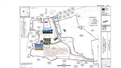


Accepting Highest and Best Offers due on or before May 14, 2025 at noon E.S.T. No contingencies accepted. Property sold as is. Closing requested by June 30, 2025. Seller reserves the right to accept an offer at any time. Offering 40+/- acres of land that once was occupied by the Bill Willard Inc. gravel operations. Property contains flat cleared areas as well as streams, ponds and wetlands & wooded sections at the road. City sewer and water available at the street. City approval needed to connect. Currently Zoned WSP. Multiple options available for use including multiple single family/2 family lots & commercial/multi-unit residential housing options available via the site plan or special permit process. Prior usages contemplated include a Cannabis Facility (approved), Multi-unit Residential buildings, outdoor raw material storage and processing, and a commercial garage. Consult Northampton Zoning Ordinances and city officials for possible uses. See disclosures.
| Date | Type | Sale Price | Title Company |
|---|---|---|---|
| Quit Claim Deed | $150,000 | -- | |
| Quit Claim Deed | $150,000 | -- | |
| Quit Claim Deed | $150,000 | -- |
| Date | Event | Price | List to Sale | Price per Sq Ft |
|---|---|---|---|---|
| 07/31/2025 07/31/25 | Sold | $150,000 | -40.0% | -- |
| 05/23/2025 05/23/25 | Pending | -- | -- | -- |
| 05/23/2025 05/23/25 | For Sale | $250,000 | 0.0% | -- |
| 05/15/2025 05/15/25 | Pending | -- | -- | -- |
| 05/01/2025 05/01/25 | Price Changed | $250,000 | -36.7% | -- |
| 04/02/2025 04/02/25 | Price Changed | $395,000 | -12.2% | -- |
| 01/06/2025 01/06/25 | For Sale | $450,000 | -- | -- |
| Year | Tax Paid | Tax Assessment Tax Assessment Total Assessment is a certain percentage of the fair market value that is determined by local assessors to be the total taxable value of land and additions on the property. | Land | Improvement |
|---|---|---|---|---|
| 2025 | $7,340 | $526,900 | $526,900 | $0 |
| 2024 | $8,004 | $526,900 | $526,900 | $0 |
| 2023 | $8,346 | $526,900 | $526,900 | $0 |
| 2022 | $14,520 | $811,600 | $811,600 | $0 |
| 2021 | $14,097 | $811,600 | $811,600 | $0 |
| 2020 | $13,635 | $811,600 | $811,600 | $0 |
| 2019 | $12,341 | $710,500 | $560,500 | $150,000 |
| 2018 | $11,693 | $686,220 | $560,500 | $125,720 |
| 2017 | $11,453 | $686,220 | $560,500 | $125,720 |
| 2016 | $11,089 | $686,220 | $560,500 | $125,720 |
| 2015 | $10,842 | $686,220 | $560,500 | $125,720 |
| 2014 | $10,561 | $686,220 | $560,500 | $125,720 |
Seller's Agent in 2025
James Pellegrino
Borawski Real Estate
(413) 685-5698
1 in this area
11 Total Sales
Source: MLS Property Information Network (MLS PIN)
MLS Number: 73323566
APN: NHAM-000035-000029-000001
Disclaimer: Certain information contained herein is derived from information provided by parties other than Homes.com. All information provided is deemed reliable, but is not guaranteed to be accurate and should be independently verified.
![]() The property listing data and information, or the Images, set forth herein were provided to MLS Property Information Network, Inc. from third party sources, including sellers, lessors and public records, and were compiled by MLS Property Information Network, Inc. The property listing data and information, and the Images, are for the personal, non-commercial use of consumers having a good faith interest in purchasing or leasing listed properties of the type displayed to them and may not be used for any purpose other than to identify prospective properties which such consumers may have a good faith interest in purchasing or leasing. MLS Property Information Network, Inc. and its subscribers disclaim any and all representations and warranties as to the accuracy of the property listing data and information, or as to the accuracy of any of the Images, set forth herein.
The property listing data and information, or the Images, set forth herein were provided to MLS Property Information Network, Inc. from third party sources, including sellers, lessors and public records, and were compiled by MLS Property Information Network, Inc. The property listing data and information, and the Images, are for the personal, non-commercial use of consumers having a good faith interest in purchasing or leasing listed properties of the type displayed to them and may not be used for any purpose other than to identify prospective properties which such consumers may have a good faith interest in purchasing or leasing. MLS Property Information Network, Inc. and its subscribers disclaim any and all representations and warranties as to the accuracy of the property listing data and information, or as to the accuracy of any of the Images, set forth herein.
Ask me questions while you tour the home.